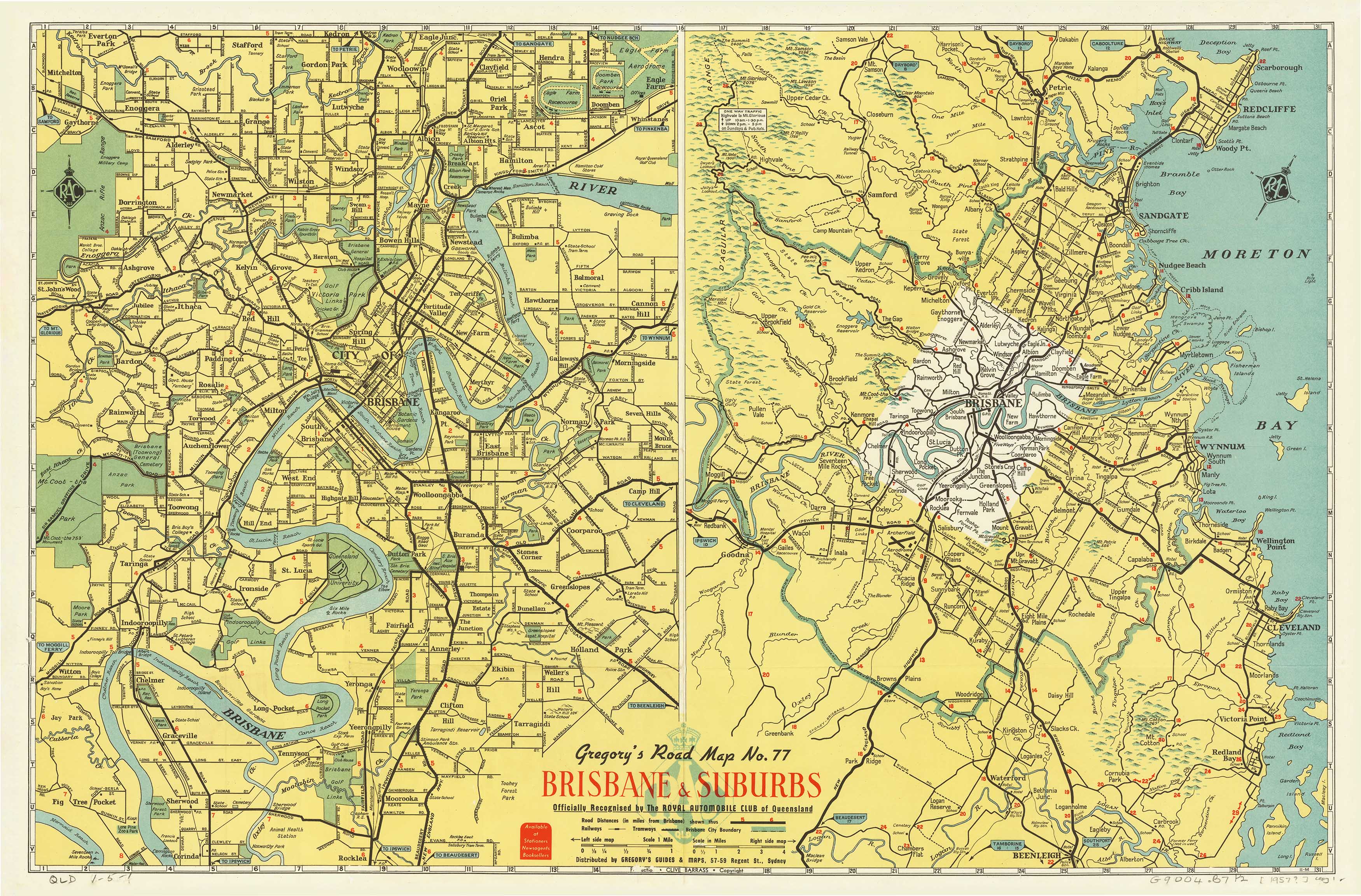
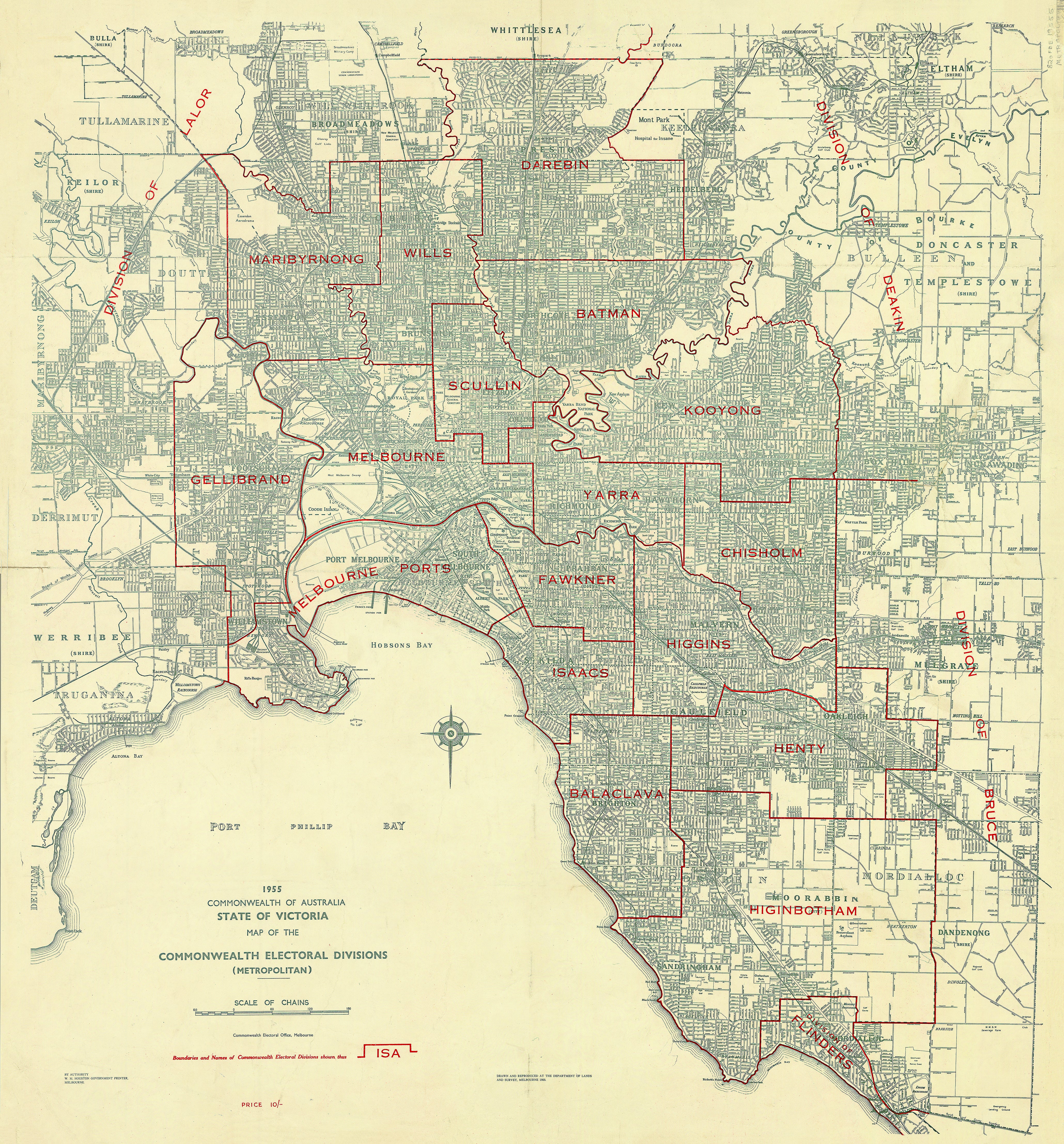
Map of Melbourne's Electoral Divisions, Victoria (1955)
1955 Commonwealth of Australia — Victoria (Metropolitan Sheet)
Commonwealth Electoral Divisions — Melbourne & Inner Suburbs
This Metropolitan Victoria sheet offers a tightly focused, authoritative view of Melbourne and its surrounding suburbs at a pivotal point in Australia’s electoral history. Drawn and reproduced by the Department of Crown Lands and Survey for the Commonwealth Electoral Office, it documents the official federal electoral boundaries in force in 1955, at the height of post-war population growth and suburban expansion.
This is not a decorative reinterpretation—it is a working government map, produced for electoral administration, redistribution clarity, and parliamentary accuracy. As such, it carries an unmistakable sense of authority and precision, capturing Melbourne just as it was consolidating its role as Australia’s largest and most influential city.
What You’ll See on the Map
-
All Commonwealth electoral divisions across metropolitan Melbourne
-
Clearly delineated division boundaries, designed to manage high urban population density
-
Suburban layout reflecting mid-20th-century growth corridors
-
The spatial logic of inner, middle, and outer metropolitan electorates
-
Clean, legible government symbology optimised for administrative use
This metropolitan sheet was issued as the urban companion to the extra-metropolitan Victoria sheet, allowing federal officials and the public to interpret Melbourne’s complex electorate structure in far greater detail than a statewide map could provide.
📜 Why 1955 Matters
The year 1955 sits at a turning point in Australian political geography. Melbourne was experiencing:
-
Rapid post-war migration
-
Large-scale housing development in the suburbs
-
Increasing pressure on existing federal divisions to be redrawn
This map freezes that moment in time—showing how representation was structured before later redistributions reshaped Melbourne’s electoral landscape. For historians, planners, and collectors, it provides a rare snapshot of how political boundaries responded to one of the fastest periods of urban growth in Australia’s history.
🧭 Cartographic Character
-
Produced using official Lands & Survey drafting standards
-
Balanced composition prioritising clarity over ornament
-
Subtle tonal contrast that keeps dense metropolitan detail readable
-
Designed for desks, briefing rooms, and parliamentary reference—now equally compelling as a wall map
✨ Premium Print & Display Options
Each copy is printed in Australia using archival processes to preserve the original linework and tonal balance.
| Finish | Description |
|---|---|
| 📄 Heavyweight Paper (160 gsm matte) | Archival matte surface with excellent definition; ideal for framing under glass. |
| 🔒 Laminated (True Encapsulation) | Sealed between 2 × 80-micron gloss laminate; tear-resistant, wipe-clean, and durable. |
| 🎨 Archival Canvas (395 gsm HP Professional Matte) | Pigment-based, fade-resistant inks with strong visual presence. |
| 🪵 Laminated + Timber Hang Rails | Natural lacquered timber rails, ready to hang (allow up to 10 working days). |
| 🪵 Canvas + Timber Hang Rails | Gallery-ready, frame-free finish (allow up to 10 working days). |
📐 Size (W × H)
929 mm × 1000 mm
Orientation: Portrait
Custom sizing: Available on request.
🎯 Ideal For
-
Political and electoral history collections
-
Universities, libraries, and archives
-
Parliamentary, council, and policy offices
-
Melbourne-focused heritage and urban history displays
-
Collectors of official Australian government cartography
🤝 Our Commitment
Every map is printed locally in Australia, colour-managed, hand-checked, and packed with care. We focus on faithful reproduction, durable materials, and presentation that respects the authority of the original document.
Choose your preferred finish and display a precise, city-level record of Melbourne’s federal electoral geography as it stood in 1955.
Product Information
Product Information
Shipping & Returns
Shipping & Returns

Map of Melbourne's Electoral Divisions, Victoria (1955)
Map of Melbourne's Electoral Divisions, Victoria (1955)
1955 Commonwealth of Australia — Victoria (Metropolitan Sheet)
Commonwealth Electoral Divisions — Melbourne & Inner Suburbs
This Metropolitan Victoria sheet offers a tightly focused, authoritative view of Melbourne and its surrounding suburbs at a pivotal point in Australia’s electoral history. Drawn and reproduced by the Department of Crown Lands and Survey for the Commonwealth Electoral Office, it documents the official federal electoral boundaries in force in 1955, at the height of post-war population growth and suburban expansion.
This is not a decorative reinterpretation—it is a working government map, produced for electoral administration, redistribution clarity, and parliamentary accuracy. As such, it carries an unmistakable sense of authority and precision, capturing Melbourne just as it was consolidating its role as Australia’s largest and most influential city.
What You’ll See on the Map
-
All Commonwealth electoral divisions across metropolitan Melbourne
-
Clearly delineated division boundaries, designed to manage high urban population density
-
Suburban layout reflecting mid-20th-century growth corridors
-
The spatial logic of inner, middle, and outer metropolitan electorates
-
Clean, legible government symbology optimised for administrative use
This metropolitan sheet was issued as the urban companion to the extra-metropolitan Victoria sheet, allowing federal officials and the public to interpret Melbourne’s complex electorate structure in far greater detail than a statewide map could provide.
📜 Why 1955 Matters
The year 1955 sits at a turning point in Australian political geography. Melbourne was experiencing:
-
Rapid post-war migration
-
Large-scale housing development in the suburbs
-
Increasing pressure on existing federal divisions to be redrawn
This map freezes that moment in time—showing how representation was structured before later redistributions reshaped Melbourne’s electoral landscape. For historians, planners, and collectors, it provides a rare snapshot of how political boundaries responded to one of the fastest periods of urban growth in Australia’s history.
🧭 Cartographic Character
-
Produced using official Lands & Survey drafting standards
-
Balanced composition prioritising clarity over ornament
-
Subtle tonal contrast that keeps dense metropolitan detail readable
-
Designed for desks, briefing rooms, and parliamentary reference—now equally compelling as a wall map
✨ Premium Print & Display Options
Each copy is printed in Australia using archival processes to preserve the original linework and tonal balance.
| Finish | Description |
|---|---|
| 📄 Heavyweight Paper (160 gsm matte) | Archival matte surface with excellent definition; ideal for framing under glass. |
| 🔒 Laminated (True Encapsulation) | Sealed between 2 × 80-micron gloss laminate; tear-resistant, wipe-clean, and durable. |
| 🎨 Archival Canvas (395 gsm HP Professional Matte) | Pigment-based, fade-resistant inks with strong visual presence. |
| 🪵 Laminated + Timber Hang Rails | Natural lacquered timber rails, ready to hang (allow up to 10 working days). |
| 🪵 Canvas + Timber Hang Rails | Gallery-ready, frame-free finish (allow up to 10 working days). |
📐 Size (W × H)
929 mm × 1000 mm
Orientation: Portrait
Custom sizing: Available on request.
🎯 Ideal For
-
Political and electoral history collections
-
Universities, libraries, and archives
-
Parliamentary, council, and policy offices
-
Melbourne-focused heritage and urban history displays
-
Collectors of official Australian government cartography
🤝 Our Commitment
Every map is printed locally in Australia, colour-managed, hand-checked, and packed with care. We focus on faithful reproduction, durable materials, and presentation that respects the authority of the original document.
Choose your preferred finish and display a precise, city-level record of Melbourne’s federal electoral geography as it stood in 1955.
Original: $89.95
-70%$89.95
$26.98Product Information
Product Information
Shipping & Returns
Shipping & Returns
Description
1955 Commonwealth of Australia — Victoria (Metropolitan Sheet)
Commonwealth Electoral Divisions — Melbourne & Inner Suburbs
This Metropolitan Victoria sheet offers a tightly focused, authoritative view of Melbourne and its surrounding suburbs at a pivotal point in Australia’s electoral history. Drawn and reproduced by the Department of Crown Lands and Survey for the Commonwealth Electoral Office, it documents the official federal electoral boundaries in force in 1955, at the height of post-war population growth and suburban expansion.
This is not a decorative reinterpretation—it is a working government map, produced for electoral administration, redistribution clarity, and parliamentary accuracy. As such, it carries an unmistakable sense of authority and precision, capturing Melbourne just as it was consolidating its role as Australia’s largest and most influential city.
What You’ll See on the Map
-
All Commonwealth electoral divisions across metropolitan Melbourne
-
Clearly delineated division boundaries, designed to manage high urban population density
-
Suburban layout reflecting mid-20th-century growth corridors
-
The spatial logic of inner, middle, and outer metropolitan electorates
-
Clean, legible government symbology optimised for administrative use
This metropolitan sheet was issued as the urban companion to the extra-metropolitan Victoria sheet, allowing federal officials and the public to interpret Melbourne’s complex electorate structure in far greater detail than a statewide map could provide.
📜 Why 1955 Matters
The year 1955 sits at a turning point in Australian political geography. Melbourne was experiencing:
-
Rapid post-war migration
-
Large-scale housing development in the suburbs
-
Increasing pressure on existing federal divisions to be redrawn
This map freezes that moment in time—showing how representation was structured before later redistributions reshaped Melbourne’s electoral landscape. For historians, planners, and collectors, it provides a rare snapshot of how political boundaries responded to one of the fastest periods of urban growth in Australia’s history.
🧭 Cartographic Character
-
Produced using official Lands & Survey drafting standards
-
Balanced composition prioritising clarity over ornament
-
Subtle tonal contrast that keeps dense metropolitan detail readable
-
Designed for desks, briefing rooms, and parliamentary reference—now equally compelling as a wall map
✨ Premium Print & Display Options
Each copy is printed in Australia using archival processes to preserve the original linework and tonal balance.
| Finish | Description |
|---|---|
| 📄 Heavyweight Paper (160 gsm matte) | Archival matte surface with excellent definition; ideal for framing under glass. |
| 🔒 Laminated (True Encapsulation) | Sealed between 2 × 80-micron gloss laminate; tear-resistant, wipe-clean, and durable. |
| 🎨 Archival Canvas (395 gsm HP Professional Matte) | Pigment-based, fade-resistant inks with strong visual presence. |
| 🪵 Laminated + Timber Hang Rails | Natural lacquered timber rails, ready to hang (allow up to 10 working days). |
| 🪵 Canvas + Timber Hang Rails | Gallery-ready, frame-free finish (allow up to 10 working days). |
📐 Size (W × H)
929 mm × 1000 mm
Orientation: Portrait
Custom sizing: Available on request.
🎯 Ideal For
-
Political and electoral history collections
-
Universities, libraries, and archives
-
Parliamentary, council, and policy offices
-
Melbourne-focused heritage and urban history displays
-
Collectors of official Australian government cartography
🤝 Our Commitment
Every map is printed locally in Australia, colour-managed, hand-checked, and packed with care. We focus on faithful reproduction, durable materials, and presentation that respects the authority of the original document.
Choose your preferred finish and display a precise, city-level record of Melbourne’s federal electoral geography as it stood in 1955.