50 Miles around Birmingham 1228 x 871mm Wall Map
Explore the Heart of England in a Single, Striking Map
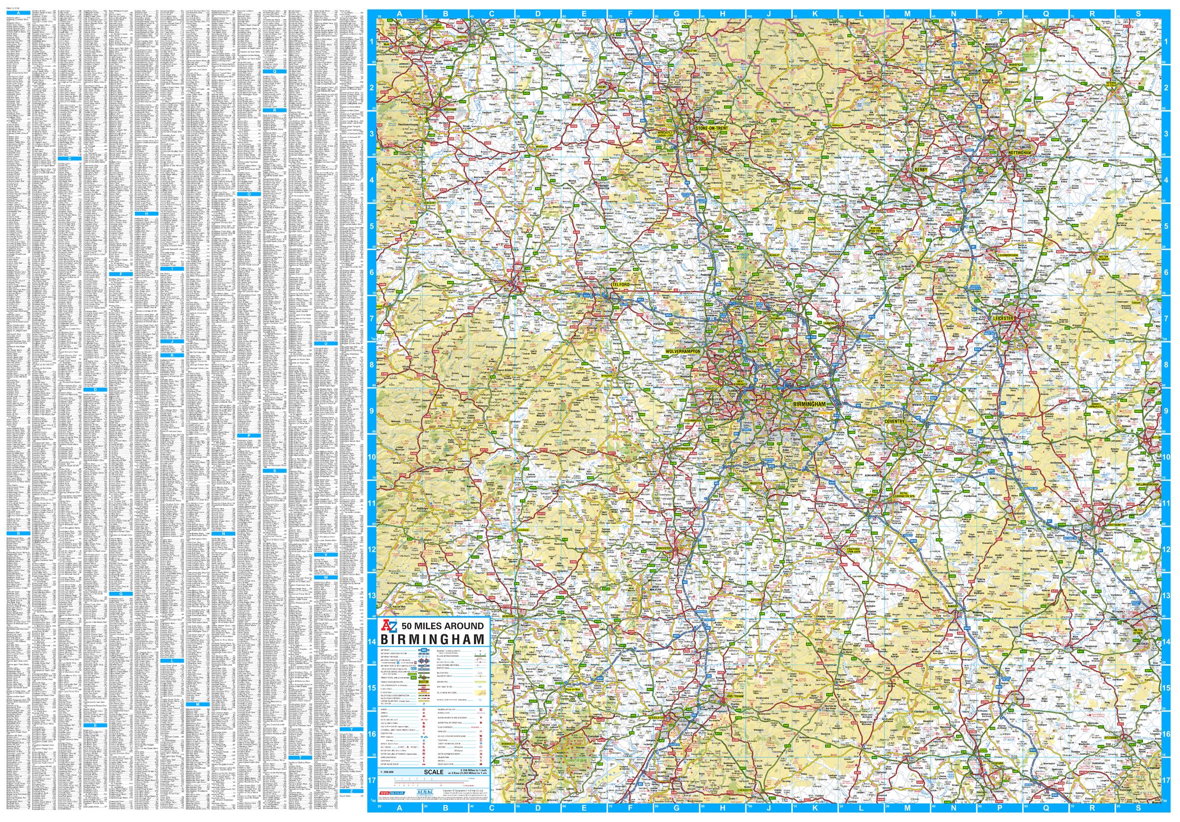
Discover the wider Midlands region with the 50 Miles Around Birmingham Wall Map by A-Z — a comprehensive and highly detailed road map designed for planning, logistics, travel, or simply for appreciating the breadth of central England. Spanning a vast circular area around Birmingham, this map includes a rich tapestry of towns, cities, and rural landscapes, all captured with the unmistakable clarity of A-Z cartography.
Covering everything from Oxford to Chester, Wrexham to Milton Keynes, this wall map gives you an unparalleled overview of England's central hub — perfect for business planning, education, or display in the home or office.
🧭 Coverage Highlights
This large-format map encompasses an impressive swathe of the UK, centred on Birmingham and radiating outward to include:
-
📍 Chester, Oswestry & Wrexham to the north and northwest
-
📍 Bakewell, Mansfield & Newark-on-Trent to the northeast
-
📍 Oxford, Milton Keynes & Aylesbury to the southeast
-
📍 Monmouth, Hereford & Bishop’s Castle to the west
-
📍 Cirencester & Corby completing the southern arc
This wide regional view makes it ideal for travel planning, regional analysis, or visualising the Midlands in context with its neighbouring regions.
🗺️ Map Features at a Glance
| ✅ Feature | 📋 Description |
|---|---|
| Road Network | Includes major roads, motorways, A-roads, and connecting routes |
| Towns & Cities | Labels key urban centres and smaller towns clearly and accurately |
| Physical Features | Depicts rivers, hills, and terrain shading for geographic context |
| Boundary Markings | Shows county and regional boundaries |
| Ideal for | Business logistics, transport planning, tourism, and general reference |
📐 Specifications
| 🔧 Specification | 📍 Detail |
|---|---|
| Title | 50 Miles Around Birmingham Wall Map |
| Publisher | A-Z Maps (Geographers' A–Z) |
| Edition | 2019 |
| Scale | 1:202,752 |
| Map Size | 1228 mm (W) × 871 mm (H) |
| Coverage Radius | Approximately 50 miles from Birmingham |
🖨️ Available Format Options
| 📄 Format | 📋 Description |
|---|---|
| Paper | Printed on premium 160 gsm coated paper — ideal for pinning or framing |
| Laminated | Gloss-laminated with 80-micron encapsulation — waterproof and dry-marker friendly |
| Laminated with Hang Rails | Supplied with timber rails and hanging cord — ready for display |
| Canvas | Printed on 395 gsm HP Matte Canvas — fade-resistant, durable, and richly textured |
| Canvas with Hang Rails | A ready-to-hang canvas version with wooden rails — elegant and professional |
👤 Perfect For:
| 🏢 Use Case | ✅ Ideal For |
|---|---|
| Business & Logistics | Delivery zones, regional sales planning, multi-location routing |
| Education & Geography | Teaching Midlands geography or urban/rural relationships |
| Public Offices & Libraries | Wall display for planning or reference |
| Home or Office Décor | Adds regional context to your workspace or study |
Whether you're mapping travel routes, managing a regional team, or simply appreciating the scale and diversity of central England, the 50 Miles Around Birmingham A-Z Wall Map is your go-to reference — big, bold, and brilliantly detailed.
Please allow up to 10 working days for delivery of hang-railed maps, as they are custom-mounted by our professional framer.
📌 Add it to your wall today — and get the Midlands in full view.
Product Information
Product Information
Shipping & Returns
Shipping & Returns
50 Miles around Birmingham 1228 x 871mm Wall Map
50 Miles around Birmingham 1228 x 871mm Wall Map
Explore the Heart of England in a Single, Striking Map
Discover the wider Midlands region with the 50 Miles Around Birmingham Wall Map by A-Z — a comprehensive and highly detailed road map designed for planning, logistics, travel, or simply for appreciating the breadth of central England. Spanning a vast circular area around Birmingham, this map includes a rich tapestry of towns, cities, and rural landscapes, all captured with the unmistakable clarity of A-Z cartography.
Covering everything from Oxford to Chester, Wrexham to Milton Keynes, this wall map gives you an unparalleled overview of England's central hub — perfect for business planning, education, or display in the home or office.
🧭 Coverage Highlights
This large-format map encompasses an impressive swathe of the UK, centred on Birmingham and radiating outward to include:
-
📍 Chester, Oswestry & Wrexham to the north and northwest
-
📍 Bakewell, Mansfield & Newark-on-Trent to the northeast
-
📍 Oxford, Milton Keynes & Aylesbury to the southeast
-
📍 Monmouth, Hereford & Bishop’s Castle to the west
-
📍 Cirencester & Corby completing the southern arc
This wide regional view makes it ideal for travel planning, regional analysis, or visualising the Midlands in context with its neighbouring regions.
🗺️ Map Features at a Glance
| ✅ Feature | 📋 Description |
|---|---|
| Road Network | Includes major roads, motorways, A-roads, and connecting routes |
| Towns & Cities | Labels key urban centres and smaller towns clearly and accurately |
| Physical Features | Depicts rivers, hills, and terrain shading for geographic context |
| Boundary Markings | Shows county and regional boundaries |
| Ideal for | Business logistics, transport planning, tourism, and general reference |
📐 Specifications
| 🔧 Specification | 📍 Detail |
|---|---|
| Title | 50 Miles Around Birmingham Wall Map |
| Publisher | A-Z Maps (Geographers' A–Z) |
| Edition | 2019 |
| Scale | 1:202,752 |
| Map Size | 1228 mm (W) × 871 mm (H) |
| Coverage Radius | Approximately 50 miles from Birmingham |
🖨️ Available Format Options
| 📄 Format | 📋 Description |
|---|---|
| Paper | Printed on premium 160 gsm coated paper — ideal for pinning or framing |
| Laminated | Gloss-laminated with 80-micron encapsulation — waterproof and dry-marker friendly |
| Laminated with Hang Rails | Supplied with timber rails and hanging cord — ready for display |
| Canvas | Printed on 395 gsm HP Matte Canvas — fade-resistant, durable, and richly textured |
| Canvas with Hang Rails | A ready-to-hang canvas version with wooden rails — elegant and professional |
👤 Perfect For:
| 🏢 Use Case | ✅ Ideal For |
|---|---|
| Business & Logistics | Delivery zones, regional sales planning, multi-location routing |
| Education & Geography | Teaching Midlands geography or urban/rural relationships |
| Public Offices & Libraries | Wall display for planning or reference |
| Home or Office Décor | Adds regional context to your workspace or study |
Whether you're mapping travel routes, managing a regional team, or simply appreciating the scale and diversity of central England, the 50 Miles Around Birmingham A-Z Wall Map is your go-to reference — big, bold, and brilliantly detailed.
Please allow up to 10 working days for delivery of hang-railed maps, as they are custom-mounted by our professional framer.
📌 Add it to your wall today — and get the Midlands in full view.
Original: $69.95
-70%$69.95
$20.98Product Information
Product Information
Shipping & Returns
Shipping & Returns
Description
Explore the Heart of England in a Single, Striking Map
Discover the wider Midlands region with the 50 Miles Around Birmingham Wall Map by A-Z — a comprehensive and highly detailed road map designed for planning, logistics, travel, or simply for appreciating the breadth of central England. Spanning a vast circular area around Birmingham, this map includes a rich tapestry of towns, cities, and rural landscapes, all captured with the unmistakable clarity of A-Z cartography.
Covering everything from Oxford to Chester, Wrexham to Milton Keynes, this wall map gives you an unparalleled overview of England's central hub — perfect for business planning, education, or display in the home or office.
🧭 Coverage Highlights
This large-format map encompasses an impressive swathe of the UK, centred on Birmingham and radiating outward to include:
-
📍 Chester, Oswestry & Wrexham to the north and northwest
-
📍 Bakewell, Mansfield & Newark-on-Trent to the northeast
-
📍 Oxford, Milton Keynes & Aylesbury to the southeast
-
📍 Monmouth, Hereford & Bishop’s Castle to the west
-
📍 Cirencester & Corby completing the southern arc
This wide regional view makes it ideal for travel planning, regional analysis, or visualising the Midlands in context with its neighbouring regions.
🗺️ Map Features at a Glance
| ✅ Feature | 📋 Description |
|---|---|
| Road Network | Includes major roads, motorways, A-roads, and connecting routes |
| Towns & Cities | Labels key urban centres and smaller towns clearly and accurately |
| Physical Features | Depicts rivers, hills, and terrain shading for geographic context |
| Boundary Markings | Shows county and regional boundaries |
| Ideal for | Business logistics, transport planning, tourism, and general reference |
📐 Specifications
| 🔧 Specification | 📍 Detail |
|---|---|
| Title | 50 Miles Around Birmingham Wall Map |
| Publisher | A-Z Maps (Geographers' A–Z) |
| Edition | 2019 |
| Scale | 1:202,752 |
| Map Size | 1228 mm (W) × 871 mm (H) |
| Coverage Radius | Approximately 50 miles from Birmingham |
🖨️ Available Format Options
| 📄 Format | 📋 Description |
|---|---|
| Paper | Printed on premium 160 gsm coated paper — ideal for pinning or framing |
| Laminated | Gloss-laminated with 80-micron encapsulation — waterproof and dry-marker friendly |
| Laminated with Hang Rails | Supplied with timber rails and hanging cord — ready for display |
| Canvas | Printed on 395 gsm HP Matte Canvas — fade-resistant, durable, and richly textured |
| Canvas with Hang Rails | A ready-to-hang canvas version with wooden rails — elegant and professional |
👤 Perfect For:
| 🏢 Use Case | ✅ Ideal For |
|---|---|
| Business & Logistics | Delivery zones, regional sales planning, multi-location routing |
| Education & Geography | Teaching Midlands geography or urban/rural relationships |
| Public Offices & Libraries | Wall display for planning or reference |
| Home or Office Décor | Adds regional context to your workspace or study |
Whether you're mapping travel routes, managing a regional team, or simply appreciating the scale and diversity of central England, the 50 Miles Around Birmingham A-Z Wall Map is your go-to reference — big, bold, and brilliantly detailed.
Please allow up to 10 working days for delivery of hang-railed maps, as they are custom-mounted by our professional framer.
📌 Add it to your wall today — and get the Midlands in full view.