Indigenous Australia Map Folded AO Size New Edition
A Cultural Portrait of Language, Country, and Connection
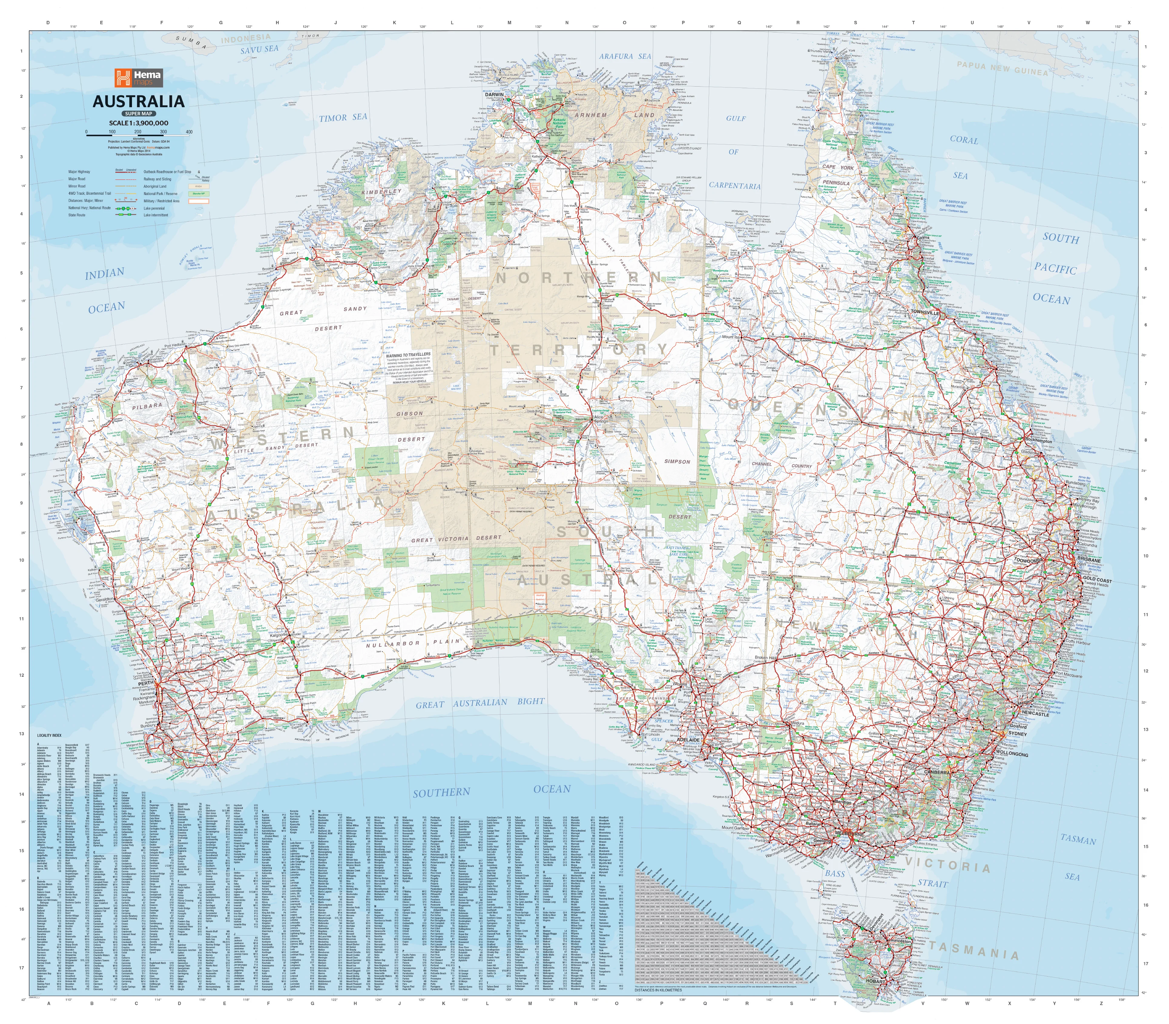
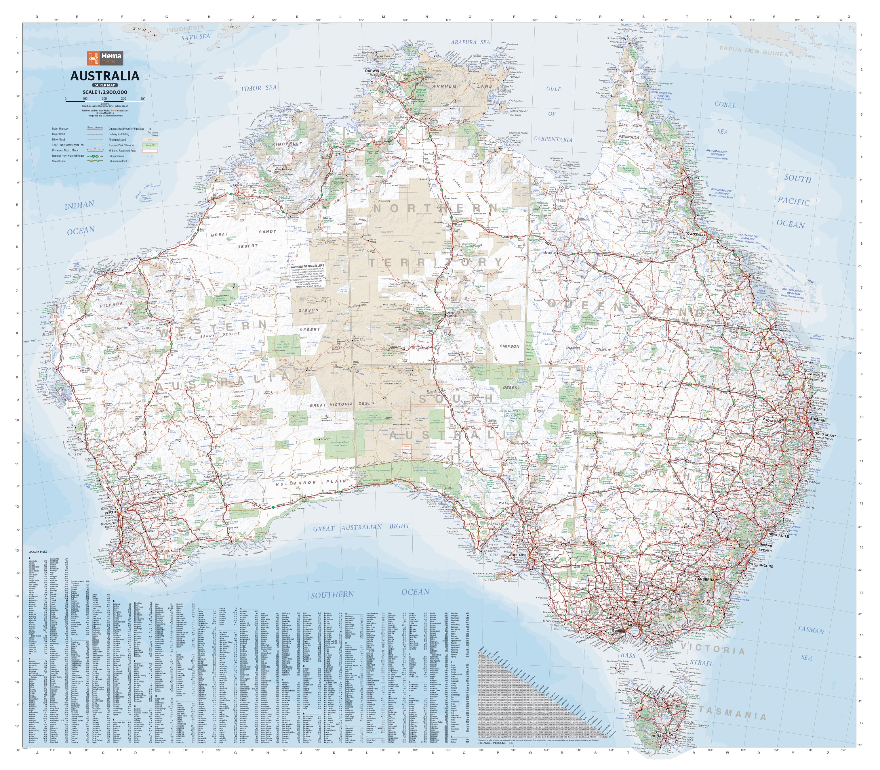
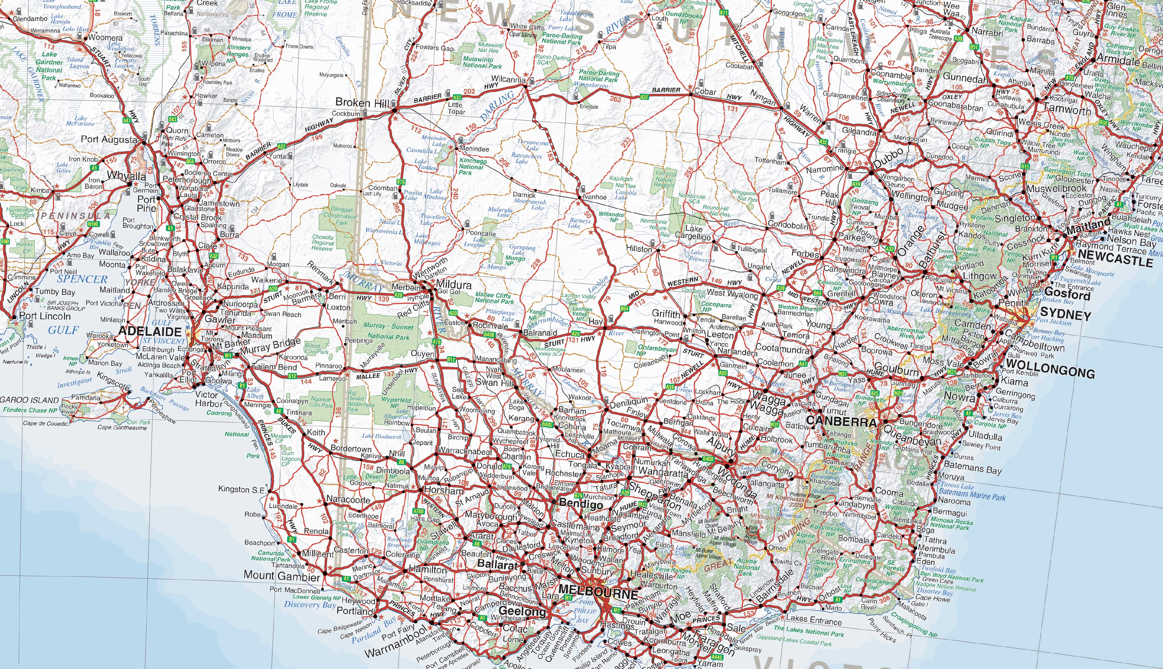
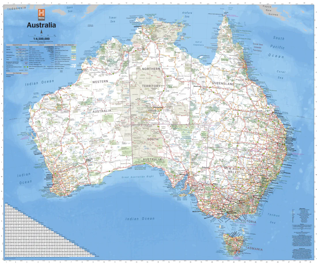
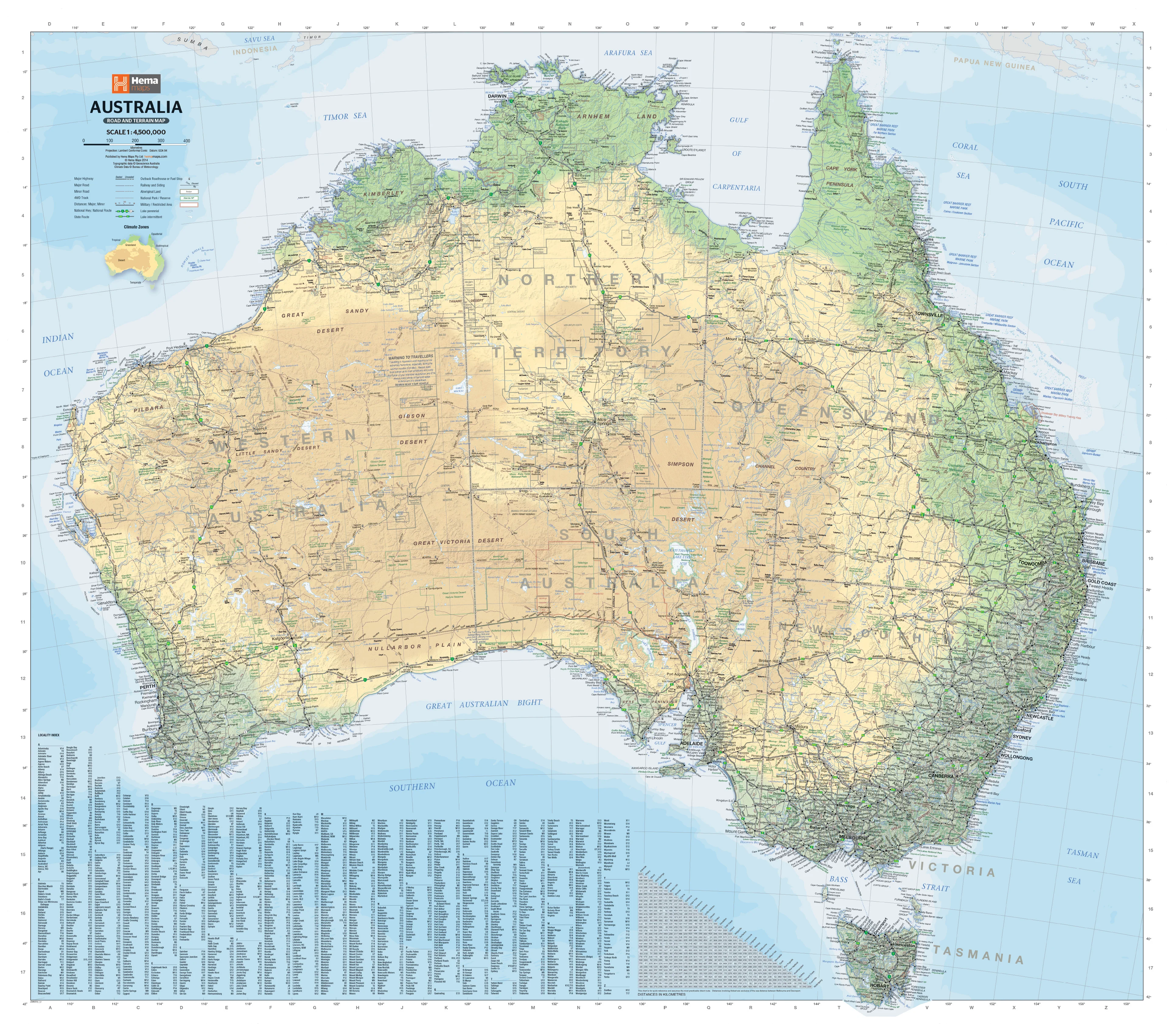
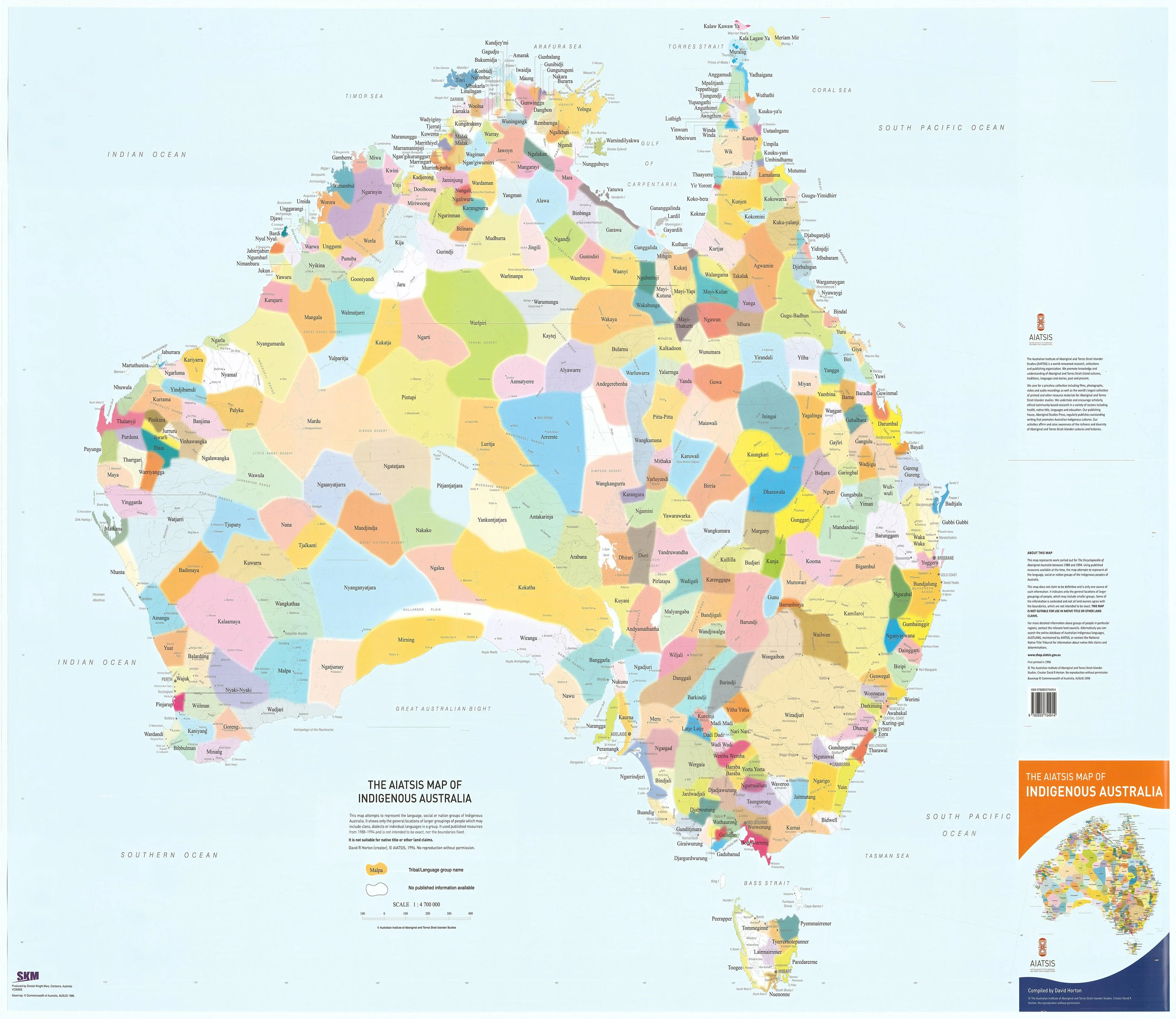
The AIATSIS Map of Indigenous Australia is one of the most respected and widely used visual representations of Aboriginal and Torres Strait Islander peoples across the continent. It highlights the remarkable diversity of over 200 language, tribal, and nation groups, offering a window into the richness and complexity of First Nations cultures.
Originally created in 1996 by David Horton for the Encyclopaedia of Aboriginal Australia, the map is the result of extensive consultation and research conducted between 1988 and 1994. Today, it remains a vital cultural, educational, and visual resource—used in classrooms, universities, homes, workplaces, and public institutions around Australia.
🔍 Important Note: This map illustrates general locations only. Boundaries are not definitive and should not be used for legal, land title, or native title purposes. It is a conceptual map, designed to foster understanding—not define territory.
🗺️ Map Features
-
Cultural Representation: Displays the broad geographic spread of Indigenous groups prior to European colonisation, offering a framework to understand First Nations' connections to land, language, and community.
([Aboriginal Bush Traders][4]) -
Colour-Coded Regions: Each area is uniquely shaded and labelled with traditional names, helping users distinguish one group from another at a glance.
-
Educational Tool: Widely used in schools, libraries, government offices, and cultural organisations to support reconciliation, Indigenous studies, and Australian history curricula.
-
Visual Storytelling: The design encourages inquiry and dialogue, making it a powerful resource for storytelling, research, and classroom discussion.
📐 Specifications
| Feature | Details |
|---|---|
| Size | 1200 mm (width) × 850 mm (height) |
| Material | High-quality paper |
| Format | Folded |
| Publisher | AIATSIS (Australian Institute of Aboriginal and Torres Strait Islander Studies) |
| Publication | 2022 Edition |
🎓 Cultural and Educational Significance
The AIATSIS Map of Indigenous Australia is more than a cartographic product—it is a cultural document, a visual act of respect, and a powerful educational resource. Used in NAIDOC Week celebrations, cultural training, curriculum development, and land-based learning, it plays a pivotal role in advancing awareness of Australia's First Nations.
Its presence on the wall serves not only as a reference, but as a reminder of resilience, continuity, and deep cultural belonging.
🖼️ Ideal For:
-
Classrooms – Teaching Indigenous history, geography, and language
-
Universities – Supporting research and First Nations programs
-
Libraries and Museums – Displaying as part of exhibitions and educational outreach
-
Government & Community Centres – Supporting reconciliation and cultural inclusion
-
Homes and Offices – Creating space for respectful learning and visual connection to Country
Product Information
Product Information
Shipping & Returns
Shipping & Returns
Indigenous Australia Map Folded AO Size New Edition
Indigenous Australia Map Folded AO Size New Edition
A Cultural Portrait of Language, Country, and Connection
The AIATSIS Map of Indigenous Australia is one of the most respected and widely used visual representations of Aboriginal and Torres Strait Islander peoples across the continent. It highlights the remarkable diversity of over 200 language, tribal, and nation groups, offering a window into the richness and complexity of First Nations cultures.
Originally created in 1996 by David Horton for the Encyclopaedia of Aboriginal Australia, the map is the result of extensive consultation and research conducted between 1988 and 1994. Today, it remains a vital cultural, educational, and visual resource—used in classrooms, universities, homes, workplaces, and public institutions around Australia.
🔍 Important Note: This map illustrates general locations only. Boundaries are not definitive and should not be used for legal, land title, or native title purposes. It is a conceptual map, designed to foster understanding—not define territory.
🗺️ Map Features
-
Cultural Representation: Displays the broad geographic spread of Indigenous groups prior to European colonisation, offering a framework to understand First Nations' connections to land, language, and community.
([Aboriginal Bush Traders][4]) -
Colour-Coded Regions: Each area is uniquely shaded and labelled with traditional names, helping users distinguish one group from another at a glance.
-
Educational Tool: Widely used in schools, libraries, government offices, and cultural organisations to support reconciliation, Indigenous studies, and Australian history curricula.
-
Visual Storytelling: The design encourages inquiry and dialogue, making it a powerful resource for storytelling, research, and classroom discussion.
📐 Specifications
| Feature | Details |
|---|---|
| Size | 1200 mm (width) × 850 mm (height) |
| Material | High-quality paper |
| Format | Folded |
| Publisher | AIATSIS (Australian Institute of Aboriginal and Torres Strait Islander Studies) |
| Publication | 2022 Edition |
🎓 Cultural and Educational Significance
The AIATSIS Map of Indigenous Australia is more than a cartographic product—it is a cultural document, a visual act of respect, and a powerful educational resource. Used in NAIDOC Week celebrations, cultural training, curriculum development, and land-based learning, it plays a pivotal role in advancing awareness of Australia's First Nations.
Its presence on the wall serves not only as a reference, but as a reminder of resilience, continuity, and deep cultural belonging.
🖼️ Ideal For:
-
Classrooms – Teaching Indigenous history, geography, and language
-
Universities – Supporting research and First Nations programs
-
Libraries and Museums – Displaying as part of exhibitions and educational outreach
-
Government & Community Centres – Supporting reconciliation and cultural inclusion
-
Homes and Offices – Creating space for respectful learning and visual connection to Country
Original: $24.95
-70%$24.95
$7.48Product Information
Product Information
Shipping & Returns
Shipping & Returns
Description
A Cultural Portrait of Language, Country, and Connection
The AIATSIS Map of Indigenous Australia is one of the most respected and widely used visual representations of Aboriginal and Torres Strait Islander peoples across the continent. It highlights the remarkable diversity of over 200 language, tribal, and nation groups, offering a window into the richness and complexity of First Nations cultures.
Originally created in 1996 by David Horton for the Encyclopaedia of Aboriginal Australia, the map is the result of extensive consultation and research conducted between 1988 and 1994. Today, it remains a vital cultural, educational, and visual resource—used in classrooms, universities, homes, workplaces, and public institutions around Australia.
🔍 Important Note: This map illustrates general locations only. Boundaries are not definitive and should not be used for legal, land title, or native title purposes. It is a conceptual map, designed to foster understanding—not define territory.
🗺️ Map Features
-
Cultural Representation: Displays the broad geographic spread of Indigenous groups prior to European colonisation, offering a framework to understand First Nations' connections to land, language, and community.
([Aboriginal Bush Traders][4]) -
Colour-Coded Regions: Each area is uniquely shaded and labelled with traditional names, helping users distinguish one group from another at a glance.
-
Educational Tool: Widely used in schools, libraries, government offices, and cultural organisations to support reconciliation, Indigenous studies, and Australian history curricula.
-
Visual Storytelling: The design encourages inquiry and dialogue, making it a powerful resource for storytelling, research, and classroom discussion.
📐 Specifications
| Feature | Details |
|---|---|
| Size | 1200 mm (width) × 850 mm (height) |
| Material | High-quality paper |
| Format | Folded |
| Publisher | AIATSIS (Australian Institute of Aboriginal and Torres Strait Islander Studies) |
| Publication | 2022 Edition |
🎓 Cultural and Educational Significance
The AIATSIS Map of Indigenous Australia is more than a cartographic product—it is a cultural document, a visual act of respect, and a powerful educational resource. Used in NAIDOC Week celebrations, cultural training, curriculum development, and land-based learning, it plays a pivotal role in advancing awareness of Australia's First Nations.
Its presence on the wall serves not only as a reference, but as a reminder of resilience, continuity, and deep cultural belonging.
🖼️ Ideal For:
-
Classrooms – Teaching Indigenous history, geography, and language
-
Universities – Supporting research and First Nations programs
-
Libraries and Museums – Displaying as part of exhibitions and educational outreach
-
Government & Community Centres – Supporting reconciliation and cultural inclusion
-
Homes and Offices – Creating space for respectful learning and visual connection to Country