Australia-in-Four - North East Sheet Wall Map
Topographic Wall Map by Geoscience Australia
Available in Two Sizes | Paper, Laminated, or Canvas Finish
Discover the Untamed North – Cape York, Gulf Country, and Northern Outback
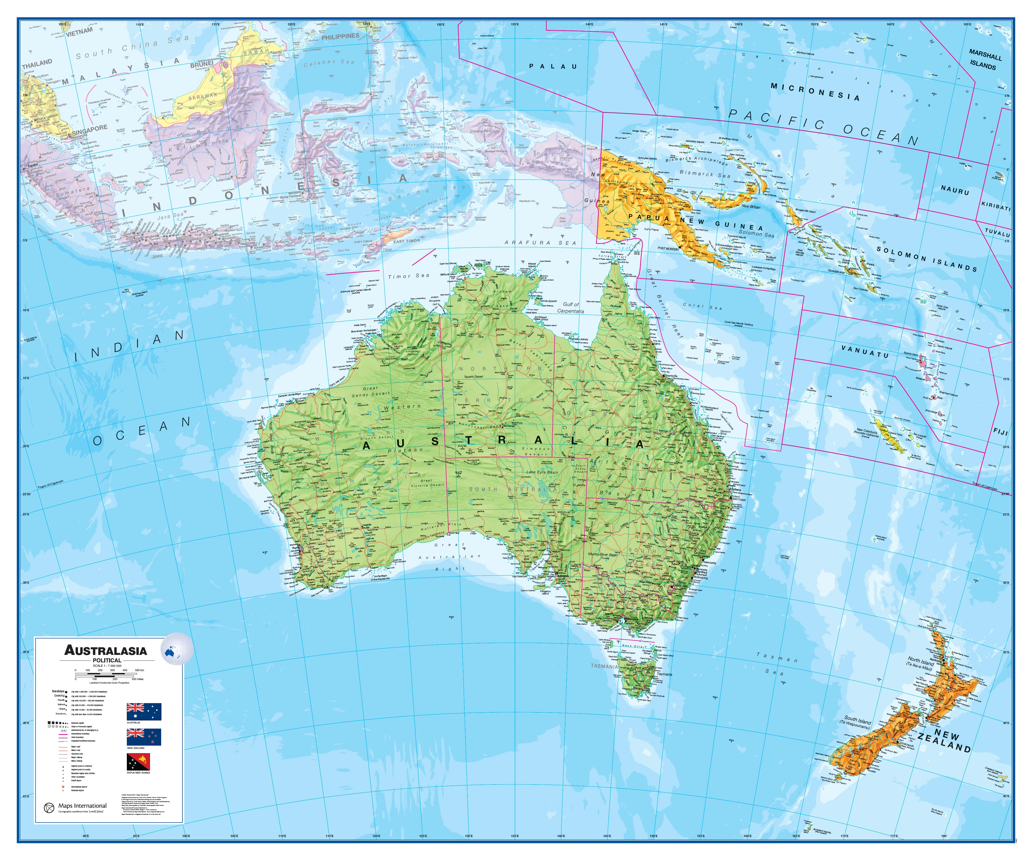
The North East Sheet is one of four beautifully crafted maps in Geoscience Australia’s Australia-in-Four series. Together, these maps are designed to form a seamless and comprehensive topographic view of the Australian continent—ideal for educators, adventurers, and anyone with a passion for the great outdoors.
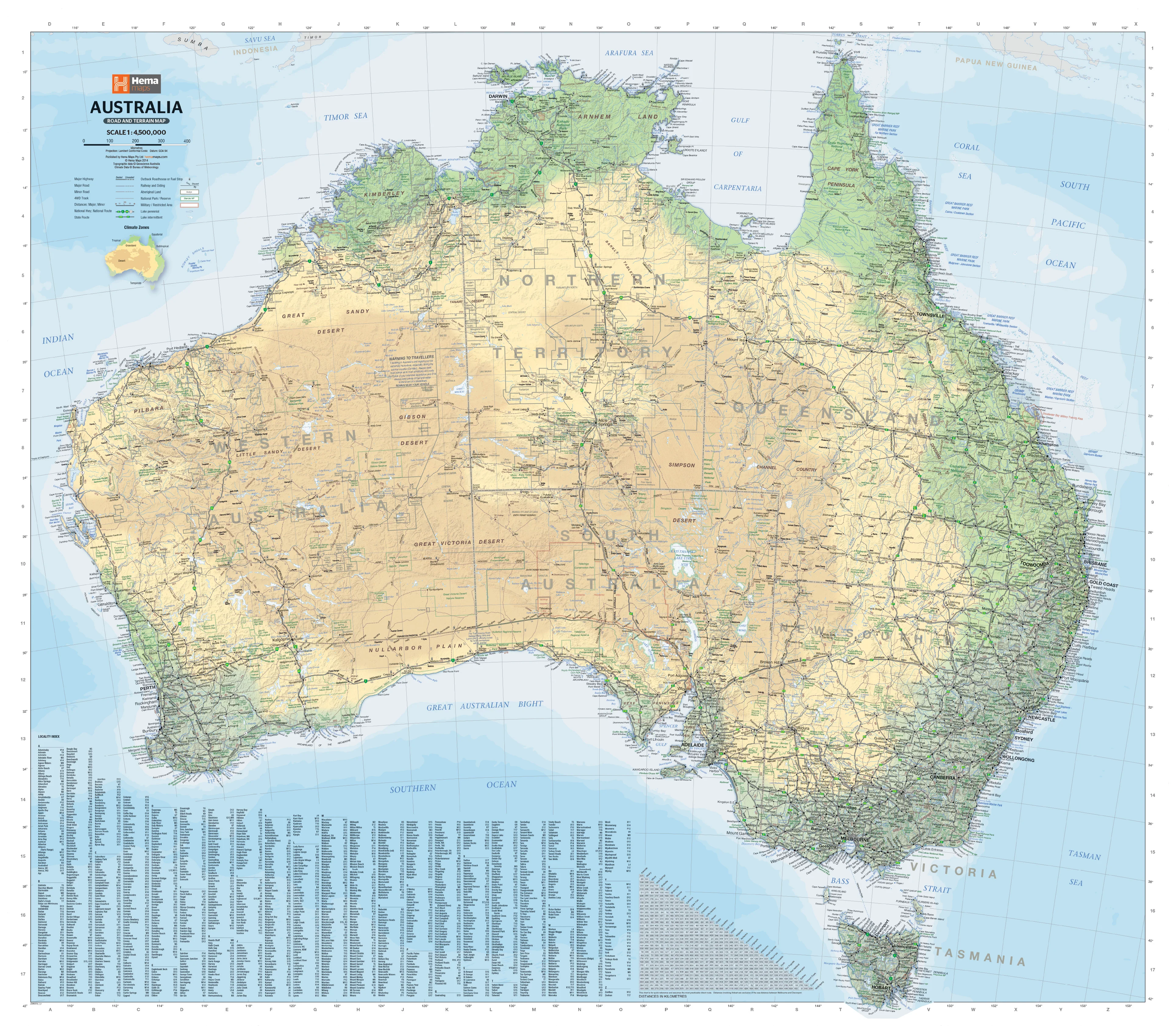
This particular sheet covers the remote and rugged Cape York Peninsula, the wild expanse of Gulf Country, and part of the Northern Territory, including major rivers, roads, terrain contours, and natural features. It’s an exceptional resource for anyone planning a journey to Australia’s tropical north or simply appreciating the unique geography of the region.
📍 Highlights of the North East Sheet
-
Covers Northern Queensland & Gulf of Carpentaria
-
From Cairns and Cooktown to the northernmost tip of Cape York
-
Includes part of the NT Gulf Region
-
-
Topographic Detail
-
Elevation shading, drainage networks, and major geographical features
-
-
Ideal for Planning
-
Whether you're plotting a 4WD expedition, a bushwalking route, or a classroom lesson
-
🖨️ Printing & Finish Options
| Finish | Description |
|---|---|
| Paper | Printed on heavyweight 160gsm matte-coated paper—ideal for framing under glass |
| Laminated | True encapsulation in 80-micron gloss laminate for durability—writable and wipeable surface |
| Canvas | Printed on 395gsm HP Professional Matte Canvas with pigment inks for fade-resistant longevity |
🖼️ Optional Timber Hang Rails for Canvas Maps
For laminated & canvas maps, we offer the option of natural timber hang rails, attached top and bottom with a hanging cord on the upper rail. This offers a simple, elegant way to hang your map—no framing required.
Note: Please allow up to 10 working days for delivery of canvas maps with hang rails, as these are hand-finished by our framer.
📏 Available Sizes
| Format | Dimensions (W x H) |
|---|---|
| Standard | 1000 mm x 850 mm |
| Large | 1200 mm x 1000 mm |
🧭 Part of a Larger Series
The Australia-in-Four series includes:
-
North East Sheet (this map)
-
North West Sheet – Pilbara, Kimberley & NT Top End
-
South East Sheet – Brisbane, Sydney, Melbourne & Adelaide
-
South West Sheet – Nullarbor Plain, Perth & Margaret River
When combined, the four maps form a spectacular large-scale display of the entire country—ideal for schools, offices, travel planners, and enthusiasts alike.
Made in Australia | Published by Geoscience Australia
A rich cartographic tribute to Australia’s remote northeast frontier.
Product Information
Product Information
Shipping & Returns
Shipping & Returns


Australia-in-Four - North East Sheet Wall Map
Australia-in-Four - North East Sheet Wall Map
Topographic Wall Map by Geoscience Australia
Available in Two Sizes | Paper, Laminated, or Canvas Finish
Discover the Untamed North – Cape York, Gulf Country, and Northern Outback
The North East Sheet is one of four beautifully crafted maps in Geoscience Australia’s Australia-in-Four series. Together, these maps are designed to form a seamless and comprehensive topographic view of the Australian continent—ideal for educators, adventurers, and anyone with a passion for the great outdoors.
This particular sheet covers the remote and rugged Cape York Peninsula, the wild expanse of Gulf Country, and part of the Northern Territory, including major rivers, roads, terrain contours, and natural features. It’s an exceptional resource for anyone planning a journey to Australia’s tropical north or simply appreciating the unique geography of the region.
📍 Highlights of the North East Sheet
-
Covers Northern Queensland & Gulf of Carpentaria
-
From Cairns and Cooktown to the northernmost tip of Cape York
-
Includes part of the NT Gulf Region
-
-
Topographic Detail
-
Elevation shading, drainage networks, and major geographical features
-
-
Ideal for Planning
-
Whether you're plotting a 4WD expedition, a bushwalking route, or a classroom lesson
-
🖨️ Printing & Finish Options
| Finish | Description |
|---|---|
| Paper | Printed on heavyweight 160gsm matte-coated paper—ideal for framing under glass |
| Laminated | True encapsulation in 80-micron gloss laminate for durability—writable and wipeable surface |
| Canvas | Printed on 395gsm HP Professional Matte Canvas with pigment inks for fade-resistant longevity |
🖼️ Optional Timber Hang Rails for Canvas Maps
For laminated & canvas maps, we offer the option of natural timber hang rails, attached top and bottom with a hanging cord on the upper rail. This offers a simple, elegant way to hang your map—no framing required.
Note: Please allow up to 10 working days for delivery of canvas maps with hang rails, as these are hand-finished by our framer.
📏 Available Sizes
| Format | Dimensions (W x H) |
|---|---|
| Standard | 1000 mm x 850 mm |
| Large | 1200 mm x 1000 mm |
🧭 Part of a Larger Series
The Australia-in-Four series includes:
-
North East Sheet (this map)
-
North West Sheet – Pilbara, Kimberley & NT Top End
-
South East Sheet – Brisbane, Sydney, Melbourne & Adelaide
-
South West Sheet – Nullarbor Plain, Perth & Margaret River
When combined, the four maps form a spectacular large-scale display of the entire country—ideal for schools, offices, travel planners, and enthusiasts alike.
Made in Australia | Published by Geoscience Australia
A rich cartographic tribute to Australia’s remote northeast frontier.
Original: $59.95
-70%$59.95
$17.98Product Information
Product Information
Shipping & Returns
Shipping & Returns
Description
Topographic Wall Map by Geoscience Australia
Available in Two Sizes | Paper, Laminated, or Canvas Finish
Discover the Untamed North – Cape York, Gulf Country, and Northern Outback
The North East Sheet is one of four beautifully crafted maps in Geoscience Australia’s Australia-in-Four series. Together, these maps are designed to form a seamless and comprehensive topographic view of the Australian continent—ideal for educators, adventurers, and anyone with a passion for the great outdoors.
This particular sheet covers the remote and rugged Cape York Peninsula, the wild expanse of Gulf Country, and part of the Northern Territory, including major rivers, roads, terrain contours, and natural features. It’s an exceptional resource for anyone planning a journey to Australia’s tropical north or simply appreciating the unique geography of the region.
📍 Highlights of the North East Sheet
-
Covers Northern Queensland & Gulf of Carpentaria
-
From Cairns and Cooktown to the northernmost tip of Cape York
-
Includes part of the NT Gulf Region
-
-
Topographic Detail
-
Elevation shading, drainage networks, and major geographical features
-
-
Ideal for Planning
-
Whether you're plotting a 4WD expedition, a bushwalking route, or a classroom lesson
-
🖨️ Printing & Finish Options
| Finish | Description |
|---|---|
| Paper | Printed on heavyweight 160gsm matte-coated paper—ideal for framing under glass |
| Laminated | True encapsulation in 80-micron gloss laminate for durability—writable and wipeable surface |
| Canvas | Printed on 395gsm HP Professional Matte Canvas with pigment inks for fade-resistant longevity |
🖼️ Optional Timber Hang Rails for Canvas Maps
For laminated & canvas maps, we offer the option of natural timber hang rails, attached top and bottom with a hanging cord on the upper rail. This offers a simple, elegant way to hang your map—no framing required.
Note: Please allow up to 10 working days for delivery of canvas maps with hang rails, as these are hand-finished by our framer.
📏 Available Sizes
| Format | Dimensions (W x H) |
|---|---|
| Standard | 1000 mm x 850 mm |
| Large | 1200 mm x 1000 mm |
🧭 Part of a Larger Series
The Australia-in-Four series includes:
-
North East Sheet (this map)
-
North West Sheet – Pilbara, Kimberley & NT Top End
-
South East Sheet – Brisbane, Sydney, Melbourne & Adelaide
-
South West Sheet – Nullarbor Plain, Perth & Margaret River
When combined, the four maps form a spectacular large-scale display of the entire country—ideal for schools, offices, travel planners, and enthusiasts alike.
Made in Australia | Published by Geoscience Australia
A rich cartographic tribute to Australia’s remote northeast frontier.