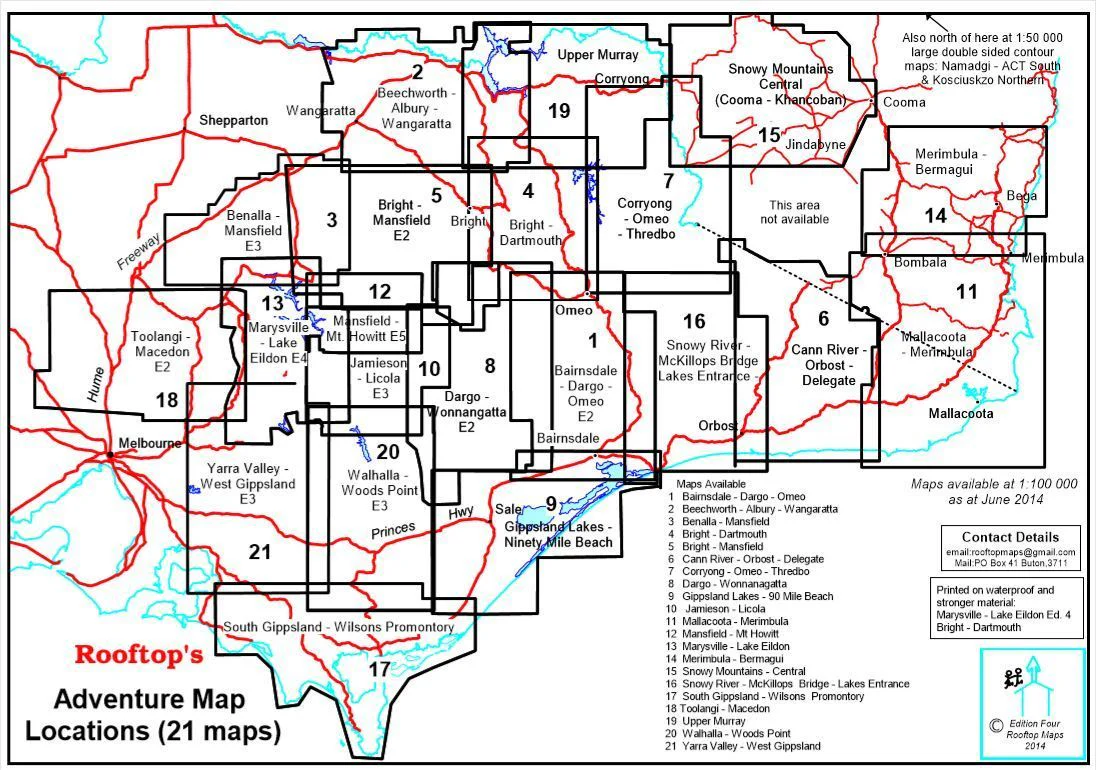
Beechworth - Albury - Wangaratta Adventure Map Rooftop
Rooftop Maps | Topographic | Laminated Optional | 1:100,000 / 1:50,000 Scale
Whether you're planning a high country hike, a weekend of off-road exploration, or simply discovering Victoria’s northeast on foot or 4WD, the Beechworth – Albury – Wangaratta Adventure Map by Rooftop Maps is the perfect companion for serious adventurers. Meticulously field-checked and GPS-plotted, this topographic map delivers unrivalled detail of this historically rich and naturally stunning region.
🏞️ Comprehensive Regional Coverage
This map provides dual-scale mapping, with a 1:100,000 scale for broad regional coverage and a 1:50,000 scale enlargement on the reverse for deeper exploration.
Coverage includes:
-
North: Rutherglen, Hume Weir, Tallangatta
-
South: Wangaratta, Myrtleford, Eskdale
-
Central: Beechworth, Stanley, Chiltern, Mount Pilot, Yackandandah
Positioned centrally, Beechworth acts as your hub for navigating the surrounding alpine valleys, state forests, and highland townships.
🔍 Detailed Adventure Features
Perfectly suited for bushwalkers, campers, 4WD enthusiasts, and cyclists, this map shows:
| Features Included | Details |
|---|---|
| 🛣️ Roads & Tracks | Over 7,500 km of GPS-verified roads and off-road tracks |
| 🗺️ Parks & Forests | All parks, reserves, and state forests clearly marked |
| 🏕️ Camping Areas | Bush camps, caravan parks, and picnic spots |
| 👁️ Lookouts & Scenic Points | Highlighted routes and viewpoints for panoramic photography |
| ⚠️ Safety & Info | Fire warnings, access restrictions, and updated amenity information |
| 🛶 Lakes & Rivers | Waterways, creeks, and access to Lake Hume and surrounding catchments |
The reverse map, titled "Beechworth Forest Activities Map", zooms in on the forested surrounds and heritage townships with 1:50,000 detail, ideal for navigation in more remote areas.
💼 Built for the Bush – Laminated Option Available
Choose the laminated version of this map to make trip planning interactive and field-proof:
-
Use whiteboard markers to sketch routes or update notes
-
Apply Map Dots to mark visited locations or waypoints
-
Wipe clean and reuse again and again
-
Laminated surface is tear-resistant and water-repellent, built for tough conditions
Note: Laminated versions are made from previously folded maps; minor crease lines may remain visible.
🧭 Map Specifications
| Attribute | Description |
|---|---|
| Publisher | Rooftop Maps |
| Coverage Area | Northeast Victoria, including Alpine Valleys |
| Main Scale | 1:100,000 |
| Reverse Scale | 1:50,000 (Beechworth Forest Focus) |
| Map Size | 700 mm (W) x 1000 mm (H) unfolded |
| Format | Paper or Laminated |
🌄 Why Choose Rooftop's Beechworth – Albury – Wangaratta Map?
-
Highly detailed, up-to-date topography
-
Trusted by bushwalkers, 4WD tourers, emergency services, and landcare groups
-
Produced by one of Australia’s most respected regional mapmakers
-
Packed with local insights, not just lines and roads
Explore deeper. Travel smarter. Stay safe.
With Rooftop’s Adventure Maps, you don’t just visit the landscape—you understand it.
Product Information
Product Information
Shipping & Returns
Shipping & Returns


Beechworth - Albury - Wangaratta Adventure Map Rooftop
Beechworth - Albury - Wangaratta Adventure Map Rooftop
Rooftop Maps | Topographic | Laminated Optional | 1:100,000 / 1:50,000 Scale
Whether you're planning a high country hike, a weekend of off-road exploration, or simply discovering Victoria’s northeast on foot or 4WD, the Beechworth – Albury – Wangaratta Adventure Map by Rooftop Maps is the perfect companion for serious adventurers. Meticulously field-checked and GPS-plotted, this topographic map delivers unrivalled detail of this historically rich and naturally stunning region.
🏞️ Comprehensive Regional Coverage
This map provides dual-scale mapping, with a 1:100,000 scale for broad regional coverage and a 1:50,000 scale enlargement on the reverse for deeper exploration.
Coverage includes:
-
North: Rutherglen, Hume Weir, Tallangatta
-
South: Wangaratta, Myrtleford, Eskdale
-
Central: Beechworth, Stanley, Chiltern, Mount Pilot, Yackandandah
Positioned centrally, Beechworth acts as your hub for navigating the surrounding alpine valleys, state forests, and highland townships.
🔍 Detailed Adventure Features
Perfectly suited for bushwalkers, campers, 4WD enthusiasts, and cyclists, this map shows:
| Features Included | Details |
|---|---|
| 🛣️ Roads & Tracks | Over 7,500 km of GPS-verified roads and off-road tracks |
| 🗺️ Parks & Forests | All parks, reserves, and state forests clearly marked |
| 🏕️ Camping Areas | Bush camps, caravan parks, and picnic spots |
| 👁️ Lookouts & Scenic Points | Highlighted routes and viewpoints for panoramic photography |
| ⚠️ Safety & Info | Fire warnings, access restrictions, and updated amenity information |
| 🛶 Lakes & Rivers | Waterways, creeks, and access to Lake Hume and surrounding catchments |
The reverse map, titled "Beechworth Forest Activities Map", zooms in on the forested surrounds and heritage townships with 1:50,000 detail, ideal for navigation in more remote areas.
💼 Built for the Bush – Laminated Option Available
Choose the laminated version of this map to make trip planning interactive and field-proof:
-
Use whiteboard markers to sketch routes or update notes
-
Apply Map Dots to mark visited locations or waypoints
-
Wipe clean and reuse again and again
-
Laminated surface is tear-resistant and water-repellent, built for tough conditions
Note: Laminated versions are made from previously folded maps; minor crease lines may remain visible.
🧭 Map Specifications
| Attribute | Description |
|---|---|
| Publisher | Rooftop Maps |
| Coverage Area | Northeast Victoria, including Alpine Valleys |
| Main Scale | 1:100,000 |
| Reverse Scale | 1:50,000 (Beechworth Forest Focus) |
| Map Size | 700 mm (W) x 1000 mm (H) unfolded |
| Format | Paper or Laminated |
🌄 Why Choose Rooftop's Beechworth – Albury – Wangaratta Map?
-
Highly detailed, up-to-date topography
-
Trusted by bushwalkers, 4WD tourers, emergency services, and landcare groups
-
Produced by one of Australia’s most respected regional mapmakers
-
Packed with local insights, not just lines and roads
Explore deeper. Travel smarter. Stay safe.
With Rooftop’s Adventure Maps, you don’t just visit the landscape—you understand it.
Original: $12.95
-70%$12.95
$3.88Product Information
Product Information
Shipping & Returns
Shipping & Returns
Description
Rooftop Maps | Topographic | Laminated Optional | 1:100,000 / 1:50,000 Scale
Whether you're planning a high country hike, a weekend of off-road exploration, or simply discovering Victoria’s northeast on foot or 4WD, the Beechworth – Albury – Wangaratta Adventure Map by Rooftop Maps is the perfect companion for serious adventurers. Meticulously field-checked and GPS-plotted, this topographic map delivers unrivalled detail of this historically rich and naturally stunning region.
🏞️ Comprehensive Regional Coverage
This map provides dual-scale mapping, with a 1:100,000 scale for broad regional coverage and a 1:50,000 scale enlargement on the reverse for deeper exploration.
Coverage includes:
-
North: Rutherglen, Hume Weir, Tallangatta
-
South: Wangaratta, Myrtleford, Eskdale
-
Central: Beechworth, Stanley, Chiltern, Mount Pilot, Yackandandah
Positioned centrally, Beechworth acts as your hub for navigating the surrounding alpine valleys, state forests, and highland townships.
🔍 Detailed Adventure Features
Perfectly suited for bushwalkers, campers, 4WD enthusiasts, and cyclists, this map shows:
| Features Included | Details |
|---|---|
| 🛣️ Roads & Tracks | Over 7,500 km of GPS-verified roads and off-road tracks |
| 🗺️ Parks & Forests | All parks, reserves, and state forests clearly marked |
| 🏕️ Camping Areas | Bush camps, caravan parks, and picnic spots |
| 👁️ Lookouts & Scenic Points | Highlighted routes and viewpoints for panoramic photography |
| ⚠️ Safety & Info | Fire warnings, access restrictions, and updated amenity information |
| 🛶 Lakes & Rivers | Waterways, creeks, and access to Lake Hume and surrounding catchments |
The reverse map, titled "Beechworth Forest Activities Map", zooms in on the forested surrounds and heritage townships with 1:50,000 detail, ideal for navigation in more remote areas.
💼 Built for the Bush – Laminated Option Available
Choose the laminated version of this map to make trip planning interactive and field-proof:
-
Use whiteboard markers to sketch routes or update notes
-
Apply Map Dots to mark visited locations or waypoints
-
Wipe clean and reuse again and again
-
Laminated surface is tear-resistant and water-repellent, built for tough conditions
Note: Laminated versions are made from previously folded maps; minor crease lines may remain visible.
🧭 Map Specifications
| Attribute | Description |
|---|---|
| Publisher | Rooftop Maps |
| Coverage Area | Northeast Victoria, including Alpine Valleys |
| Main Scale | 1:100,000 |
| Reverse Scale | 1:50,000 (Beechworth Forest Focus) |
| Map Size | 700 mm (W) x 1000 mm (H) unfolded |
| Format | Paper or Laminated |
🌄 Why Choose Rooftop's Beechworth – Albury – Wangaratta Map?
-
Highly detailed, up-to-date topography
-
Trusted by bushwalkers, 4WD tourers, emergency services, and landcare groups
-
Produced by one of Australia’s most respected regional mapmakers
-
Packed with local insights, not just lines and roads
Explore deeper. Travel smarter. Stay safe.
With Rooftop’s Adventure Maps, you don’t just visit the landscape—you understand it.