Caribbean & Main Islands by Oxford Cartographers 1000 x 690mm Wall Map
Decorative Hill-Shaded Map with Inset Islands • Available in Paper, Laminated, Canvas & Timber-Hung Formats
Scale: 1:3,500,000 | Size: 1000 mm (W) x 690 mm (H) | Made in Australia
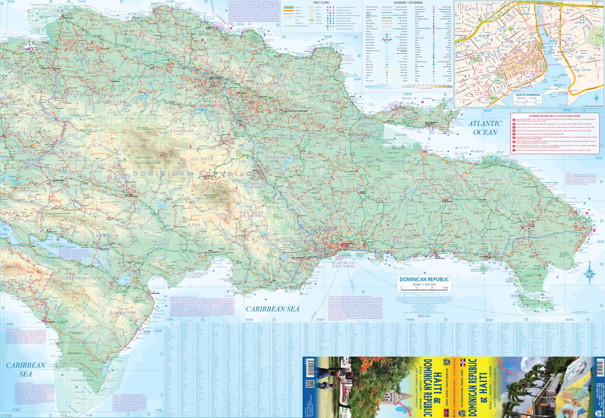
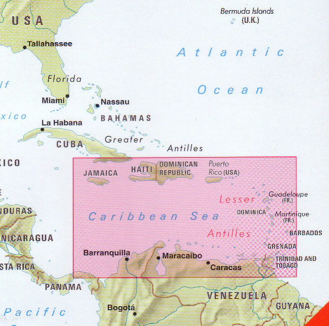
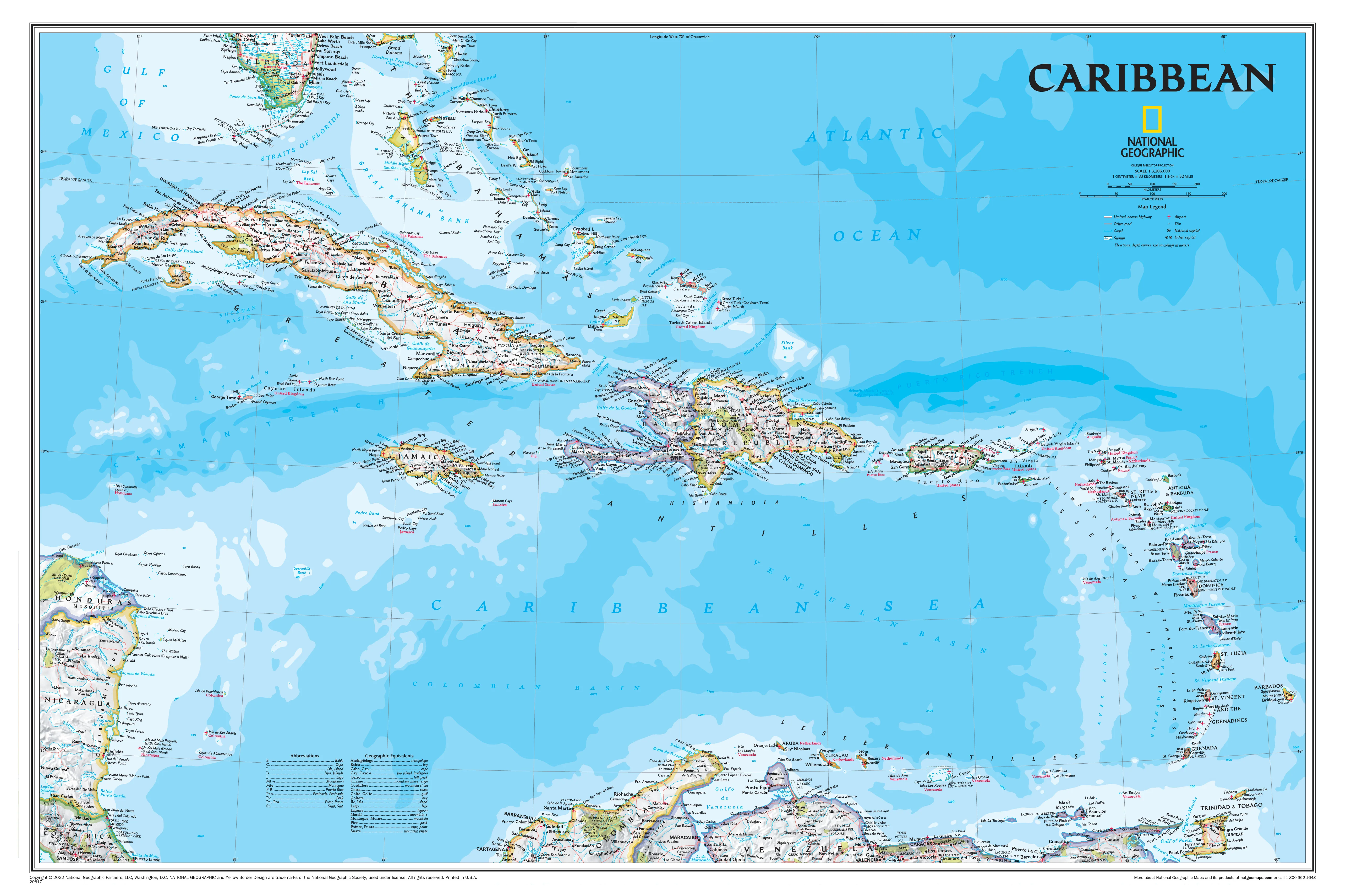
Discover the beauty, history, and topography of the Caribbean with this stunning Caribbean & Main Islands Wall Map by Oxford Cartographers. Combining elegant hill-shaded relief with eight detailed island insets, this map offers a complete visual guide to the Caribbean Basin—from Cuba and Puerto Rico to Trinidad, Barbados, and the Bahamas.
Whether you’re a traveller, educator, cruise lover, or interior designer, this map brings function and flair to any space. Available in a range of premium finishes—including canvas with natural timber hang rails—you can choose the perfect version to suit your needs and style.
🏝️ Features & Coverage
-
Scale: 1:3,500,000 – ideal for regional overview and travel planning
-
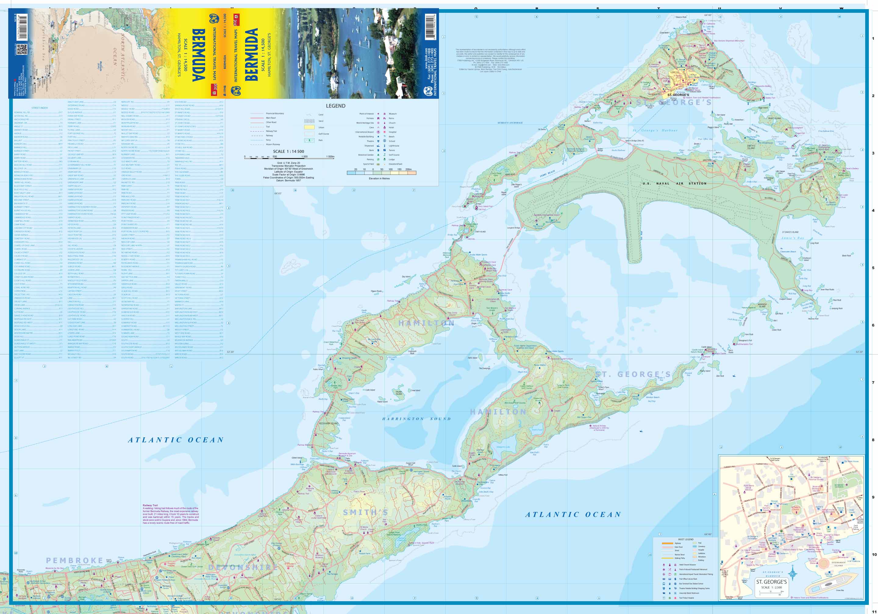
Hill-shading & bathymetry – showing both land elevation and seafloor contours
-
Clear labelling of capitals, major towns, coastlines, and international borders
-
Surrounding mainland coasts of Central and South America included
📍 Inset Maps of 8 Key Caribbean Islands:
-
Barbados
-
Jamaica
-
Cuba
-
Puerto Rico
-
Saint Lucia
-
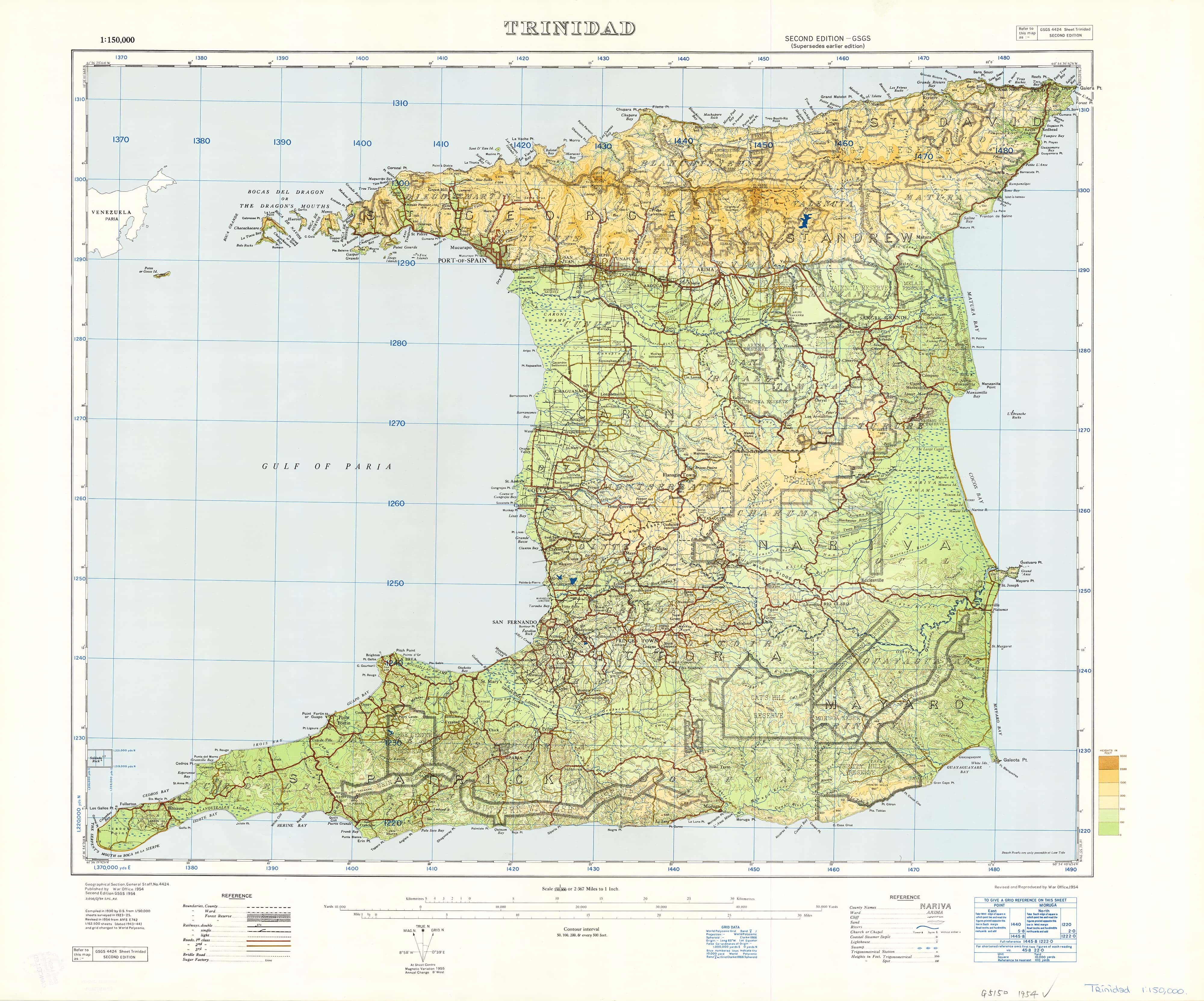
Trinidad
-
Saint Kitts & Nevis
-
The Bahamas
Each inset includes topographic detail, major towns, resort areas, and travel points of interest.
🧭 Available Formats
| Format | Description |
|---|---|
| 📄 Paper (160gsm) | Premium matte finish, ideal for framing under glass |
| 🛡️ Laminated | Gloss-laminated front and back for durability, stain resistance, and whiteboard use |
| 🖼️ Canvas (395gsm) | Printed on heavyweight HP Matte Canvas with fade-resistant pigment inks for rich colour |
| 🪵 Laminated + Hang Rails | Laminated map mounted with natural timber hang rails and hanging cord – ready to display |
| 🪵 Canvas + Hang Rails | Archival canvas with timber hang rails top and bottom, plus cord for effortless wall hanging |
🪵 Timber Hang Rail Options (Laminated & Canvas)
Both laminated and canvas versions are available with optional timber hang rails for a gallery-style finish:
-
🪵 Natural timber rails, lacquered for smoothness and durability
-
🧵 Pre-attached hanging cord – just place a hook in the wall and you’re done
-
🧷 No framing required – a clean, professional look that’s easy to update or relocate
-
💧 Laminated versions are whiteboard marker–friendly
-
🖼️ Canvas versions are ideal for stylish interiors and long-term wall display
📦 Please allow up to 10 working days for delivery of rail-mounted maps. Each piece is carefully hand-finished by our framing team.
📐 Product Specifications
| Attribute | Detail |
|---|---|
| Title | Caribbean & Main Islands Wall Map |
| Cartographer | Oxford Cartographers |
| Scale | 1:3,500,000 |
| Size | 1000 mm (W) x 690 mm (H) |
| Inset Islands | 8 islands: Cuba, Jamaica, Barbados, Puerto Rico, St. Lucia, Trinidad, St. Kitts & Nevis, The Bahamas |
| Finishes Available | Paper • Laminated • Canvas • Laminated + Rails • Canvas + Rails |
| Print Quality | Full-colour, hill-shaded, highly legible cartography |
| Made In | Australia |
🎯 Ideal For:
-
🛳️ Cruise travellers & island hoppers
-
🌍 World travellers planning Caribbean adventures
-
🏫 Teachers & students studying regional geography
-
🏡 Interior decorators & home stylists seeking a tropical feature piece
-
🗺️ Map collectors looking to expand their global wall map collection
-
🧾 Travel agencies & tourism offices wanting a professional reference map
🛒 Add to Cart – Your Caribbean Wall Statement Starts Here
From classroom to boardroom, home office to beach house, the Caribbean & Main Islands Wall Map by Oxford Cartographers brings colour, accuracy, and inspiration to your wall. Choose your preferred format above—whether for practical reference, travel planning, or decorative elegance.
Product Information
Product Information
Shipping & Returns
Shipping & Returns

Caribbean & Main Islands by Oxford Cartographers 1000 x 690mm Wall Map
Caribbean & Main Islands by Oxford Cartographers 1000 x 690mm Wall Map
Decorative Hill-Shaded Map with Inset Islands • Available in Paper, Laminated, Canvas & Timber-Hung Formats
Scale: 1:3,500,000 | Size: 1000 mm (W) x 690 mm (H) | Made in Australia
Discover the beauty, history, and topography of the Caribbean with this stunning Caribbean & Main Islands Wall Map by Oxford Cartographers. Combining elegant hill-shaded relief with eight detailed island insets, this map offers a complete visual guide to the Caribbean Basin—from Cuba and Puerto Rico to Trinidad, Barbados, and the Bahamas.
Whether you’re a traveller, educator, cruise lover, or interior designer, this map brings function and flair to any space. Available in a range of premium finishes—including canvas with natural timber hang rails—you can choose the perfect version to suit your needs and style.
🏝️ Features & Coverage
-
Scale: 1:3,500,000 – ideal for regional overview and travel planning
-
Hill-shading & bathymetry – showing both land elevation and seafloor contours
-
Clear labelling of capitals, major towns, coastlines, and international borders
-
Surrounding mainland coasts of Central and South America included
📍 Inset Maps of 8 Key Caribbean Islands:
-
Barbados
-
Jamaica
-
Cuba
-
Puerto Rico
-
Saint Lucia
-
Trinidad
-
Saint Kitts & Nevis
-
The Bahamas
Each inset includes topographic detail, major towns, resort areas, and travel points of interest.
🧭 Available Formats
| Format | Description |
|---|---|
| 📄 Paper (160gsm) | Premium matte finish, ideal for framing under glass |
| 🛡️ Laminated | Gloss-laminated front and back for durability, stain resistance, and whiteboard use |
| 🖼️ Canvas (395gsm) | Printed on heavyweight HP Matte Canvas with fade-resistant pigment inks for rich colour |
| 🪵 Laminated + Hang Rails | Laminated map mounted with natural timber hang rails and hanging cord – ready to display |
| 🪵 Canvas + Hang Rails | Archival canvas with timber hang rails top and bottom, plus cord for effortless wall hanging |
🪵 Timber Hang Rail Options (Laminated & Canvas)
Both laminated and canvas versions are available with optional timber hang rails for a gallery-style finish:
-
🪵 Natural timber rails, lacquered for smoothness and durability
-
🧵 Pre-attached hanging cord – just place a hook in the wall and you’re done
-
🧷 No framing required – a clean, professional look that’s easy to update or relocate
-
💧 Laminated versions are whiteboard marker–friendly
-
🖼️ Canvas versions are ideal for stylish interiors and long-term wall display
📦 Please allow up to 10 working days for delivery of rail-mounted maps. Each piece is carefully hand-finished by our framing team.
📐 Product Specifications
| Attribute | Detail |
|---|---|
| Title | Caribbean & Main Islands Wall Map |
| Cartographer | Oxford Cartographers |
| Scale | 1:3,500,000 |
| Size | 1000 mm (W) x 690 mm (H) |
| Inset Islands | 8 islands: Cuba, Jamaica, Barbados, Puerto Rico, St. Lucia, Trinidad, St. Kitts & Nevis, The Bahamas |
| Finishes Available | Paper • Laminated • Canvas • Laminated + Rails • Canvas + Rails |
| Print Quality | Full-colour, hill-shaded, highly legible cartography |
| Made In | Australia |
🎯 Ideal For:
-
🛳️ Cruise travellers & island hoppers
-
🌍 World travellers planning Caribbean adventures
-
🏫 Teachers & students studying regional geography
-
🏡 Interior decorators & home stylists seeking a tropical feature piece
-
🗺️ Map collectors looking to expand their global wall map collection
-
🧾 Travel agencies & tourism offices wanting a professional reference map
🛒 Add to Cart – Your Caribbean Wall Statement Starts Here
From classroom to boardroom, home office to beach house, the Caribbean & Main Islands Wall Map by Oxford Cartographers brings colour, accuracy, and inspiration to your wall. Choose your preferred format above—whether for practical reference, travel planning, or decorative elegance.
Original: $59.95
-70%$59.95
$17.98Product Information
Product Information
Shipping & Returns
Shipping & Returns
Description
Decorative Hill-Shaded Map with Inset Islands • Available in Paper, Laminated, Canvas & Timber-Hung Formats
Scale: 1:3,500,000 | Size: 1000 mm (W) x 690 mm (H) | Made in Australia
Discover the beauty, history, and topography of the Caribbean with this stunning Caribbean & Main Islands Wall Map by Oxford Cartographers. Combining elegant hill-shaded relief with eight detailed island insets, this map offers a complete visual guide to the Caribbean Basin—from Cuba and Puerto Rico to Trinidad, Barbados, and the Bahamas.
Whether you’re a traveller, educator, cruise lover, or interior designer, this map brings function and flair to any space. Available in a range of premium finishes—including canvas with natural timber hang rails—you can choose the perfect version to suit your needs and style.
🏝️ Features & Coverage
-
Scale: 1:3,500,000 – ideal for regional overview and travel planning
-
Hill-shading & bathymetry – showing both land elevation and seafloor contours
-
Clear labelling of capitals, major towns, coastlines, and international borders
-
Surrounding mainland coasts of Central and South America included
📍 Inset Maps of 8 Key Caribbean Islands:
-
Barbados
-
Jamaica
-
Cuba
-
Puerto Rico
-
Saint Lucia
-
Trinidad
-
Saint Kitts & Nevis
-
The Bahamas
Each inset includes topographic detail, major towns, resort areas, and travel points of interest.
🧭 Available Formats
| Format | Description |
|---|---|
| 📄 Paper (160gsm) | Premium matte finish, ideal for framing under glass |
| 🛡️ Laminated | Gloss-laminated front and back for durability, stain resistance, and whiteboard use |
| 🖼️ Canvas (395gsm) | Printed on heavyweight HP Matte Canvas with fade-resistant pigment inks for rich colour |
| 🪵 Laminated + Hang Rails | Laminated map mounted with natural timber hang rails and hanging cord – ready to display |
| 🪵 Canvas + Hang Rails | Archival canvas with timber hang rails top and bottom, plus cord for effortless wall hanging |
🪵 Timber Hang Rail Options (Laminated & Canvas)
Both laminated and canvas versions are available with optional timber hang rails for a gallery-style finish:
-
🪵 Natural timber rails, lacquered for smoothness and durability
-
🧵 Pre-attached hanging cord – just place a hook in the wall and you’re done
-
🧷 No framing required – a clean, professional look that’s easy to update or relocate
-
💧 Laminated versions are whiteboard marker–friendly
-
🖼️ Canvas versions are ideal for stylish interiors and long-term wall display
📦 Please allow up to 10 working days for delivery of rail-mounted maps. Each piece is carefully hand-finished by our framing team.
📐 Product Specifications
| Attribute | Detail |
|---|---|
| Title | Caribbean & Main Islands Wall Map |
| Cartographer | Oxford Cartographers |
| Scale | 1:3,500,000 |
| Size | 1000 mm (W) x 690 mm (H) |
| Inset Islands | 8 islands: Cuba, Jamaica, Barbados, Puerto Rico, St. Lucia, Trinidad, St. Kitts & Nevis, The Bahamas |
| Finishes Available | Paper • Laminated • Canvas • Laminated + Rails • Canvas + Rails |
| Print Quality | Full-colour, hill-shaded, highly legible cartography |
| Made In | Australia |
🎯 Ideal For:
-
🛳️ Cruise travellers & island hoppers
-
🌍 World travellers planning Caribbean adventures
-
🏫 Teachers & students studying regional geography
-
🏡 Interior decorators & home stylists seeking a tropical feature piece
-
🗺️ Map collectors looking to expand their global wall map collection
-
🧾 Travel agencies & tourism offices wanting a professional reference map
🛒 Add to Cart – Your Caribbean Wall Statement Starts Here
From classroom to boardroom, home office to beach house, the Caribbean & Main Islands Wall Map by Oxford Cartographers brings colour, accuracy, and inspiration to your wall. Choose your preferred format above—whether for practical reference, travel planning, or decorative elegance.