Dublin Streetfinder Collins Map
Street-Level Detail | Durable Card Cover | Fully Indexed
Scale: 1:15,840 (4 inches to 1 mile)
ISBN: 9780008369958
Publisher: HarperCollins Publishers
Edition: 2020 (10th Edition)
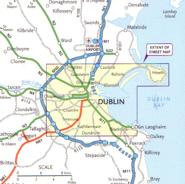
Navigate your way through Ireland’s capital with confidence using the Collins Dublin Streetfinder Colour Map — a clear, full-colour, and street-level map designed for travellers, residents, and professionals alike. Whether you're exploring historic landmarks, locating transport hubs, or planning a business trip, this detailed and fully updated city map offers exceptional clarity, practical information, and durable construction in a compact folded format.
🧭 Detailed Coverage
This map provides comprehensive coverage of Dublin, from the coastal neighbourhoods to the city's vibrant inner suburbs:
-
🧭 North – Includes Ballymun, Baldoyle, and Dublin Airport area
-
🌳 West – Covers Phoenix Park, Castleknock, and Blanchardstown
-
🏙️ Central Dublin – Full detail of key districts such as Temple Bar, Grafton Street, St. Stephen’s Green, Trinity College, and O’Connell Street
-
🏞️ South – Extends to Rathmines, Dundrum, and Milltown
-
🌊 East – Stretches to the Dublin Docklands, Sandymount, and the Irish Sea coast
🌟 Key Features
-
🗺️ Street-Level Mapping
Clear, easy-to-read full-colour map with road names, building footprints, and neighbourhoods fully labeled. -
🧾 Comprehensive Index of Street Names
Quickly locate any street in Dublin with an easy-to-use, alphabetically ordered index. -
🏛️ Tourist Information
Important buildings and points of interest clearly highlighted, including:-
Museums, galleries, and libraries
-
Historic landmarks and statues
-
Hotels, parks, shopping districts, and civic buildings
-
-
🚉 Transport Infrastructure
-
Luas tramlines and stops (Red & Green Lines)
-
Train and DART stations
-
Major bus routes and orbital roads
-
Key road connections and junctions
-
-
🅿️ Practical City Information
-
Public car parks
-
One-way streets and roundabouts
-
Speed enforcement zones
-
Fixed Garda safety camera locations
-
-
📐 Metric Conversion Chart & Map Symbols Guide
Includes helpful tools for navigating speed limits, measurements, and symbols used on the map. -
📚 Bonus Guide to Central Dublin
Historical overview, shopping suggestions, transport tips, and local travel advice included on reverse panel.
📏 Specifications
| Feature | Detail |
|---|---|
| Format | Folded street map with durable card cover |
| Scale | 1:15,840 (4 inches to 1 mile) |
| Map Size (flat) | Approx. 1000 mm x 680 mm (varies slightly) |
| Folded Size | 243 mm x 110 mm (approx. 9.6" x 4.3") |
| Weight | 140 g (approximate) |
| Material | High-quality paper with card cover |
| ISBN | 9780008369958 |
| Language | English |
| Publisher | Collins Maps / HarperCollins UK |
🧳 Who’s It For?
Perfect for:
-
🏠 Dublin residents keeping an up-to-date reference at home or work
-
✈️ Visitors and tourists exploring Dublin’s rich heritage, dining, and nightlife
-
🧭 Backpackers and independent travellers navigating on foot or by public transport
-
🚗 Self-drive travellers and city motorists planning parking and navigation routes
-
💼 Business professionals and delivery drivers who need accurate, quick-reference mapping
-
🎓 Students and educators based at universities across the city
📍 Why Choose the Collins Dublin Streetfinder Map?
-
✅ More detailed than a typical tourist map – great for longer stays and navigating lesser-known areas
-
✅ Stronger and more practical than digital-only solutions – no battery, signal, or glare issues
-
✅ Professionally updated and published – includes recent road developments and transport expansions
-
✅ Easy to fold and store – fits in a handbag, backpack, or glovebox
Whether you're walking the cobbled streets of Temple Bar, catching a Luas tram to Dundrum, or exploring the Georgian architecture of Merrion Square, this durable and comprehensive Collins Dublin Streetfinder Map will help you do it all with confidence and clarity.
Product Information
Product Information
Shipping & Returns
Shipping & Returns


Dublin Streetfinder Collins Map
Dublin Streetfinder Collins Map
Street-Level Detail | Durable Card Cover | Fully Indexed
Scale: 1:15,840 (4 inches to 1 mile)
ISBN: 9780008369958
Publisher: HarperCollins Publishers
Edition: 2020 (10th Edition)
Navigate your way through Ireland’s capital with confidence using the Collins Dublin Streetfinder Colour Map — a clear, full-colour, and street-level map designed for travellers, residents, and professionals alike. Whether you're exploring historic landmarks, locating transport hubs, or planning a business trip, this detailed and fully updated city map offers exceptional clarity, practical information, and durable construction in a compact folded format.
🧭 Detailed Coverage
This map provides comprehensive coverage of Dublin, from the coastal neighbourhoods to the city's vibrant inner suburbs:
-
🧭 North – Includes Ballymun, Baldoyle, and Dublin Airport area
-
🌳 West – Covers Phoenix Park, Castleknock, and Blanchardstown
-
🏙️ Central Dublin – Full detail of key districts such as Temple Bar, Grafton Street, St. Stephen’s Green, Trinity College, and O’Connell Street
-
🏞️ South – Extends to Rathmines, Dundrum, and Milltown
-
🌊 East – Stretches to the Dublin Docklands, Sandymount, and the Irish Sea coast
🌟 Key Features
-
🗺️ Street-Level Mapping
Clear, easy-to-read full-colour map with road names, building footprints, and neighbourhoods fully labeled. -
🧾 Comprehensive Index of Street Names
Quickly locate any street in Dublin with an easy-to-use, alphabetically ordered index. -
🏛️ Tourist Information
Important buildings and points of interest clearly highlighted, including:-
Museums, galleries, and libraries
-
Historic landmarks and statues
-
Hotels, parks, shopping districts, and civic buildings
-
-
🚉 Transport Infrastructure
-
Luas tramlines and stops (Red & Green Lines)
-
Train and DART stations
-
Major bus routes and orbital roads
-
Key road connections and junctions
-
-
🅿️ Practical City Information
-
Public car parks
-
One-way streets and roundabouts
-
Speed enforcement zones
-
Fixed Garda safety camera locations
-
-
📐 Metric Conversion Chart & Map Symbols Guide
Includes helpful tools for navigating speed limits, measurements, and symbols used on the map. -
📚 Bonus Guide to Central Dublin
Historical overview, shopping suggestions, transport tips, and local travel advice included on reverse panel.
📏 Specifications
| Feature | Detail |
|---|---|
| Format | Folded street map with durable card cover |
| Scale | 1:15,840 (4 inches to 1 mile) |
| Map Size (flat) | Approx. 1000 mm x 680 mm (varies slightly) |
| Folded Size | 243 mm x 110 mm (approx. 9.6" x 4.3") |
| Weight | 140 g (approximate) |
| Material | High-quality paper with card cover |
| ISBN | 9780008369958 |
| Language | English |
| Publisher | Collins Maps / HarperCollins UK |
🧳 Who’s It For?
Perfect for:
-
🏠 Dublin residents keeping an up-to-date reference at home or work
-
✈️ Visitors and tourists exploring Dublin’s rich heritage, dining, and nightlife
-
🧭 Backpackers and independent travellers navigating on foot or by public transport
-
🚗 Self-drive travellers and city motorists planning parking and navigation routes
-
💼 Business professionals and delivery drivers who need accurate, quick-reference mapping
-
🎓 Students and educators based at universities across the city
📍 Why Choose the Collins Dublin Streetfinder Map?
-
✅ More detailed than a typical tourist map – great for longer stays and navigating lesser-known areas
-
✅ Stronger and more practical than digital-only solutions – no battery, signal, or glare issues
-
✅ Professionally updated and published – includes recent road developments and transport expansions
-
✅ Easy to fold and store – fits in a handbag, backpack, or glovebox
Whether you're walking the cobbled streets of Temple Bar, catching a Luas tram to Dundrum, or exploring the Georgian architecture of Merrion Square, this durable and comprehensive Collins Dublin Streetfinder Map will help you do it all with confidence and clarity.
Product Information
Product Information
Shipping & Returns
Shipping & Returns
Description
Street-Level Detail | Durable Card Cover | Fully Indexed
Scale: 1:15,840 (4 inches to 1 mile)
ISBN: 9780008369958
Publisher: HarperCollins Publishers
Edition: 2020 (10th Edition)
Navigate your way through Ireland’s capital with confidence using the Collins Dublin Streetfinder Colour Map — a clear, full-colour, and street-level map designed for travellers, residents, and professionals alike. Whether you're exploring historic landmarks, locating transport hubs, or planning a business trip, this detailed and fully updated city map offers exceptional clarity, practical information, and durable construction in a compact folded format.
🧭 Detailed Coverage
This map provides comprehensive coverage of Dublin, from the coastal neighbourhoods to the city's vibrant inner suburbs:
-
🧭 North – Includes Ballymun, Baldoyle, and Dublin Airport area
-
🌳 West – Covers Phoenix Park, Castleknock, and Blanchardstown
-
🏙️ Central Dublin – Full detail of key districts such as Temple Bar, Grafton Street, St. Stephen’s Green, Trinity College, and O’Connell Street
-
🏞️ South – Extends to Rathmines, Dundrum, and Milltown
-
🌊 East – Stretches to the Dublin Docklands, Sandymount, and the Irish Sea coast
🌟 Key Features
-
🗺️ Street-Level Mapping
Clear, easy-to-read full-colour map with road names, building footprints, and neighbourhoods fully labeled. -
🧾 Comprehensive Index of Street Names
Quickly locate any street in Dublin with an easy-to-use, alphabetically ordered index. -
🏛️ Tourist Information
Important buildings and points of interest clearly highlighted, including:-
Museums, galleries, and libraries
-
Historic landmarks and statues
-
Hotels, parks, shopping districts, and civic buildings
-
-
🚉 Transport Infrastructure
-
Luas tramlines and stops (Red & Green Lines)
-
Train and DART stations
-
Major bus routes and orbital roads
-
Key road connections and junctions
-
-
🅿️ Practical City Information
-
Public car parks
-
One-way streets and roundabouts
-
Speed enforcement zones
-
Fixed Garda safety camera locations
-
-
📐 Metric Conversion Chart & Map Symbols Guide
Includes helpful tools for navigating speed limits, measurements, and symbols used on the map. -
📚 Bonus Guide to Central Dublin
Historical overview, shopping suggestions, transport tips, and local travel advice included on reverse panel.
📏 Specifications
| Feature | Detail |
|---|---|
| Format | Folded street map with durable card cover |
| Scale | 1:15,840 (4 inches to 1 mile) |
| Map Size (flat) | Approx. 1000 mm x 680 mm (varies slightly) |
| Folded Size | 243 mm x 110 mm (approx. 9.6" x 4.3") |
| Weight | 140 g (approximate) |
| Material | High-quality paper with card cover |
| ISBN | 9780008369958 |
| Language | English |
| Publisher | Collins Maps / HarperCollins UK |
🧳 Who’s It For?
Perfect for:
-
🏠 Dublin residents keeping an up-to-date reference at home or work
-
✈️ Visitors and tourists exploring Dublin’s rich heritage, dining, and nightlife
-
🧭 Backpackers and independent travellers navigating on foot or by public transport
-
🚗 Self-drive travellers and city motorists planning parking and navigation routes
-
💼 Business professionals and delivery drivers who need accurate, quick-reference mapping
-
🎓 Students and educators based at universities across the city
📍 Why Choose the Collins Dublin Streetfinder Map?
-
✅ More detailed than a typical tourist map – great for longer stays and navigating lesser-known areas
-
✅ Stronger and more practical than digital-only solutions – no battery, signal, or glare issues
-
✅ Professionally updated and published – includes recent road developments and transport expansions
-
✅ Easy to fold and store – fits in a handbag, backpack, or glovebox
Whether you're walking the cobbled streets of Temple Bar, catching a Luas tram to Dundrum, or exploring the Georgian architecture of Merrion Square, this durable and comprehensive Collins Dublin Streetfinder Map will help you do it all with confidence and clarity.