Ethiopia Wall Map 914 x 610mm
Physical & Political Detail | Shaded Relief | Premium Finishes
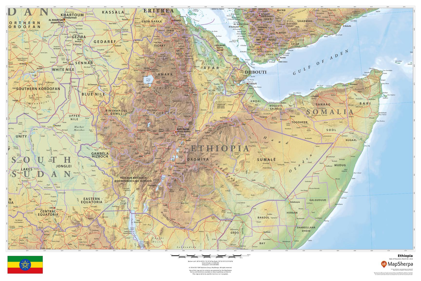
Discover Ethiopia in vivid detail with this beautifully designed wall map, showcasing both physical terrain and political boundaries. Elegant relief shading and color-by-elevation make mountains, plateaus, and valleys leap off the page, while key cities, roads, rivers, lakes, and borders are clearly labeled for effortless reference.
🗺️ Features & Highlights
-
Physical + Political Coverage: See Ethiopia’s regions, major settlements, transport routes, and waterways at a glance.
-
Relief Shading & Elevation Colors: Intuitive color gradients reveal the dramatic highlands and Rift Valley.
-
Clarity You Can Trust: Clean typography and balanced labeling for study, planning, or décor.
-
Contextual Geography: Includes surrounding areas for regional orientation and travel planning.
✨ Available Finishes
| Format | Description |
|---|---|
| 📜 Paper (160 gsm) | Heavyweight matte-coated paper—perfect for framing under glass. |
| 🧼 Laminated (Encapsulated) | Fully sealed between two sheets of 80-micron gloss laminate—durable, wipe-clean, classroom-ready. |
| 🪵 Laminated with Wooden Hang Rails | Laminated map mounted with lacquered natural timber rails (top & bottom) plus a sturdy hanging cord—ready to display. |
| 🖼️ Canvas (395 gsm) | Printed on HP Professional Matte Canvas with archival pigment inks—rich texture, fade-resistant, gallery quality. |
| 🪵 Canvas with Wooden Hang Rails | Canvas mounted with timber rails and hanging cord for a timeless, ready-to-hang presentation—no frame required. |
🔨 Note: Hang-railed maps are custom mounted—please allow up to 10 working days.
📐 Specifications
| Feature | Detail |
|---|---|
| Title | Ethiopia Wall Map |
| Map Type | Physical / Political |
| Scale | 1:3,000,000 |
| Dimensions | 914 mm (W) × 610 mm (H) |
| Materials | Paper, Laminated, Canvas, with or without Timber Rails |
| Printing | Pigment-based, fade-resistant inks |
🎁 Perfect For
-
Homes & Offices: A sophisticated statement piece with educational value.
-
Classrooms & Libraries: Durable formats that invite exploration and discussion.
-
Travellers & Planners: Visual context for routes, regions, and terrain.
-
Cartography Lovers: Premium production and crisp, legible detail.
🚚 Delivery
-
Paper, Laminated, Canvas (rolled): Typically ship within 1–2 business days.
-
Hang-Railed Maps: Made to order—allow up to 10 working days.
-
Protective Packaging: Securely packed to arrive in perfect condition.
🔶 Make It a Daily Source of Inspiration
Elevate your wall with a piece that informs, inspires, and invites exploration. Whether you’re a teacher building a captivating classroom, a traveller planning your next journey, or a collector curating beautiful cartography, this map delivers museum-worthy presence and everyday practicality. Choose the finish that suits your space—Paper for elegant framing, Laminated for durability, or Canvas with timber rails for a timeless, ready-to-hang statement—and make Ethiopia’s dramatic highlands and valleys a daily source of curiosity and conversation. Add it to your cart now and bring the geography of Ethiopia to life in your home, office, or studio.
Product Information
Product Information
Shipping & Returns
Shipping & Returns
Ethiopia Wall Map 914 x 610mm
Ethiopia Wall Map 914 x 610mm
Physical & Political Detail | Shaded Relief | Premium Finishes
Discover Ethiopia in vivid detail with this beautifully designed wall map, showcasing both physical terrain and political boundaries. Elegant relief shading and color-by-elevation make mountains, plateaus, and valleys leap off the page, while key cities, roads, rivers, lakes, and borders are clearly labeled for effortless reference.
🗺️ Features & Highlights
-
Physical + Political Coverage: See Ethiopia’s regions, major settlements, transport routes, and waterways at a glance.
-
Relief Shading & Elevation Colors: Intuitive color gradients reveal the dramatic highlands and Rift Valley.
-
Clarity You Can Trust: Clean typography and balanced labeling for study, planning, or décor.
-
Contextual Geography: Includes surrounding areas for regional orientation and travel planning.
✨ Available Finishes
| Format | Description |
|---|---|
| 📜 Paper (160 gsm) | Heavyweight matte-coated paper—perfect for framing under glass. |
| 🧼 Laminated (Encapsulated) | Fully sealed between two sheets of 80-micron gloss laminate—durable, wipe-clean, classroom-ready. |
| 🪵 Laminated with Wooden Hang Rails | Laminated map mounted with lacquered natural timber rails (top & bottom) plus a sturdy hanging cord—ready to display. |
| 🖼️ Canvas (395 gsm) | Printed on HP Professional Matte Canvas with archival pigment inks—rich texture, fade-resistant, gallery quality. |
| 🪵 Canvas with Wooden Hang Rails | Canvas mounted with timber rails and hanging cord for a timeless, ready-to-hang presentation—no frame required. |
🔨 Note: Hang-railed maps are custom mounted—please allow up to 10 working days.
📐 Specifications
| Feature | Detail |
|---|---|
| Title | Ethiopia Wall Map |
| Map Type | Physical / Political |
| Scale | 1:3,000,000 |
| Dimensions | 914 mm (W) × 610 mm (H) |
| Materials | Paper, Laminated, Canvas, with or without Timber Rails |
| Printing | Pigment-based, fade-resistant inks |
🎁 Perfect For
-
Homes & Offices: A sophisticated statement piece with educational value.
-
Classrooms & Libraries: Durable formats that invite exploration and discussion.
-
Travellers & Planners: Visual context for routes, regions, and terrain.
-
Cartography Lovers: Premium production and crisp, legible detail.
🚚 Delivery
-
Paper, Laminated, Canvas (rolled): Typically ship within 1–2 business days.
-
Hang-Railed Maps: Made to order—allow up to 10 working days.
-
Protective Packaging: Securely packed to arrive in perfect condition.
🔶 Make It a Daily Source of Inspiration
Elevate your wall with a piece that informs, inspires, and invites exploration. Whether you’re a teacher building a captivating classroom, a traveller planning your next journey, or a collector curating beautiful cartography, this map delivers museum-worthy presence and everyday practicality. Choose the finish that suits your space—Paper for elegant framing, Laminated for durability, or Canvas with timber rails for a timeless, ready-to-hang statement—and make Ethiopia’s dramatic highlands and valleys a daily source of curiosity and conversation. Add it to your cart now and bring the geography of Ethiopia to life in your home, office, or studio.
Original: $69.95
-70%$69.95
$20.98Product Information
Product Information
Shipping & Returns
Shipping & Returns
Description
Physical & Political Detail | Shaded Relief | Premium Finishes
Discover Ethiopia in vivid detail with this beautifully designed wall map, showcasing both physical terrain and political boundaries. Elegant relief shading and color-by-elevation make mountains, plateaus, and valleys leap off the page, while key cities, roads, rivers, lakes, and borders are clearly labeled for effortless reference.
🗺️ Features & Highlights
-
Physical + Political Coverage: See Ethiopia’s regions, major settlements, transport routes, and waterways at a glance.
-
Relief Shading & Elevation Colors: Intuitive color gradients reveal the dramatic highlands and Rift Valley.
-
Clarity You Can Trust: Clean typography and balanced labeling for study, planning, or décor.
-
Contextual Geography: Includes surrounding areas for regional orientation and travel planning.
✨ Available Finishes
| Format | Description |
|---|---|
| 📜 Paper (160 gsm) | Heavyweight matte-coated paper—perfect for framing under glass. |
| 🧼 Laminated (Encapsulated) | Fully sealed between two sheets of 80-micron gloss laminate—durable, wipe-clean, classroom-ready. |
| 🪵 Laminated with Wooden Hang Rails | Laminated map mounted with lacquered natural timber rails (top & bottom) plus a sturdy hanging cord—ready to display. |
| 🖼️ Canvas (395 gsm) | Printed on HP Professional Matte Canvas with archival pigment inks—rich texture, fade-resistant, gallery quality. |
| 🪵 Canvas with Wooden Hang Rails | Canvas mounted with timber rails and hanging cord for a timeless, ready-to-hang presentation—no frame required. |
🔨 Note: Hang-railed maps are custom mounted—please allow up to 10 working days.
📐 Specifications
| Feature | Detail |
|---|---|
| Title | Ethiopia Wall Map |
| Map Type | Physical / Political |
| Scale | 1:3,000,000 |
| Dimensions | 914 mm (W) × 610 mm (H) |
| Materials | Paper, Laminated, Canvas, with or without Timber Rails |
| Printing | Pigment-based, fade-resistant inks |
🎁 Perfect For
-
Homes & Offices: A sophisticated statement piece with educational value.
-
Classrooms & Libraries: Durable formats that invite exploration and discussion.
-
Travellers & Planners: Visual context for routes, regions, and terrain.
-
Cartography Lovers: Premium production and crisp, legible detail.
🚚 Delivery
-
Paper, Laminated, Canvas (rolled): Typically ship within 1–2 business days.
-
Hang-Railed Maps: Made to order—allow up to 10 working days.
-
Protective Packaging: Securely packed to arrive in perfect condition.
🔶 Make It a Daily Source of Inspiration
Elevate your wall with a piece that informs, inspires, and invites exploration. Whether you’re a teacher building a captivating classroom, a traveller planning your next journey, or a collector curating beautiful cartography, this map delivers museum-worthy presence and everyday practicality. Choose the finish that suits your space—Paper for elegant framing, Laminated for durability, or Canvas with timber rails for a timeless, ready-to-hang statement—and make Ethiopia’s dramatic highlands and valleys a daily source of curiosity and conversation. Add it to your cart now and bring the geography of Ethiopia to life in your home, office, or studio.