Kavango - Zambezi - Traks4Africa Map
Kavango–Zambezi (KAZA) — Tracks4Africa Overlander Map
Scale 1 : 1,000,000 | Waterproof PolyArt | Five-Nation Safari Region
🐘 Okavango • Chobe • Victoria Falls • Kafue • Makgadikgadi
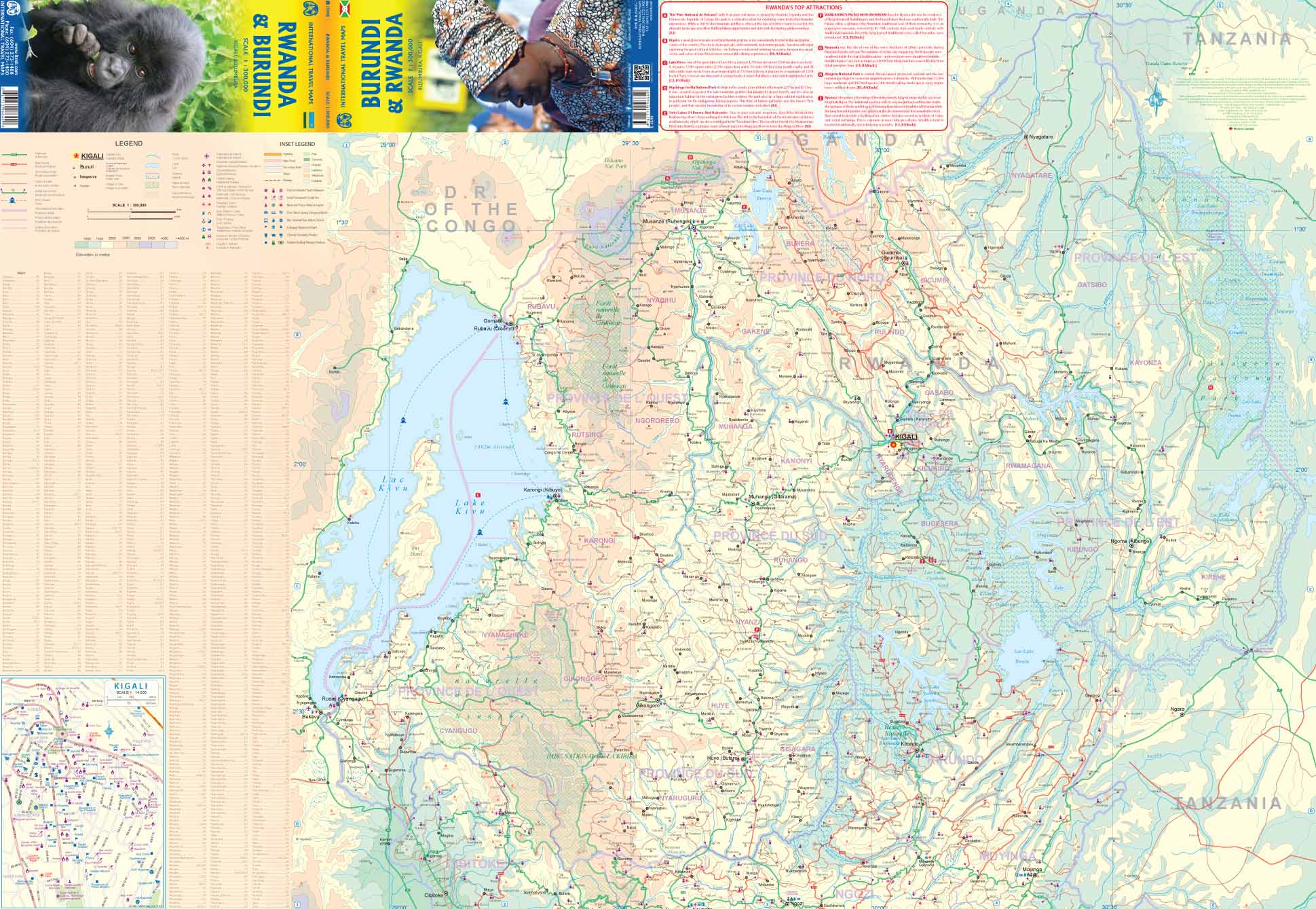
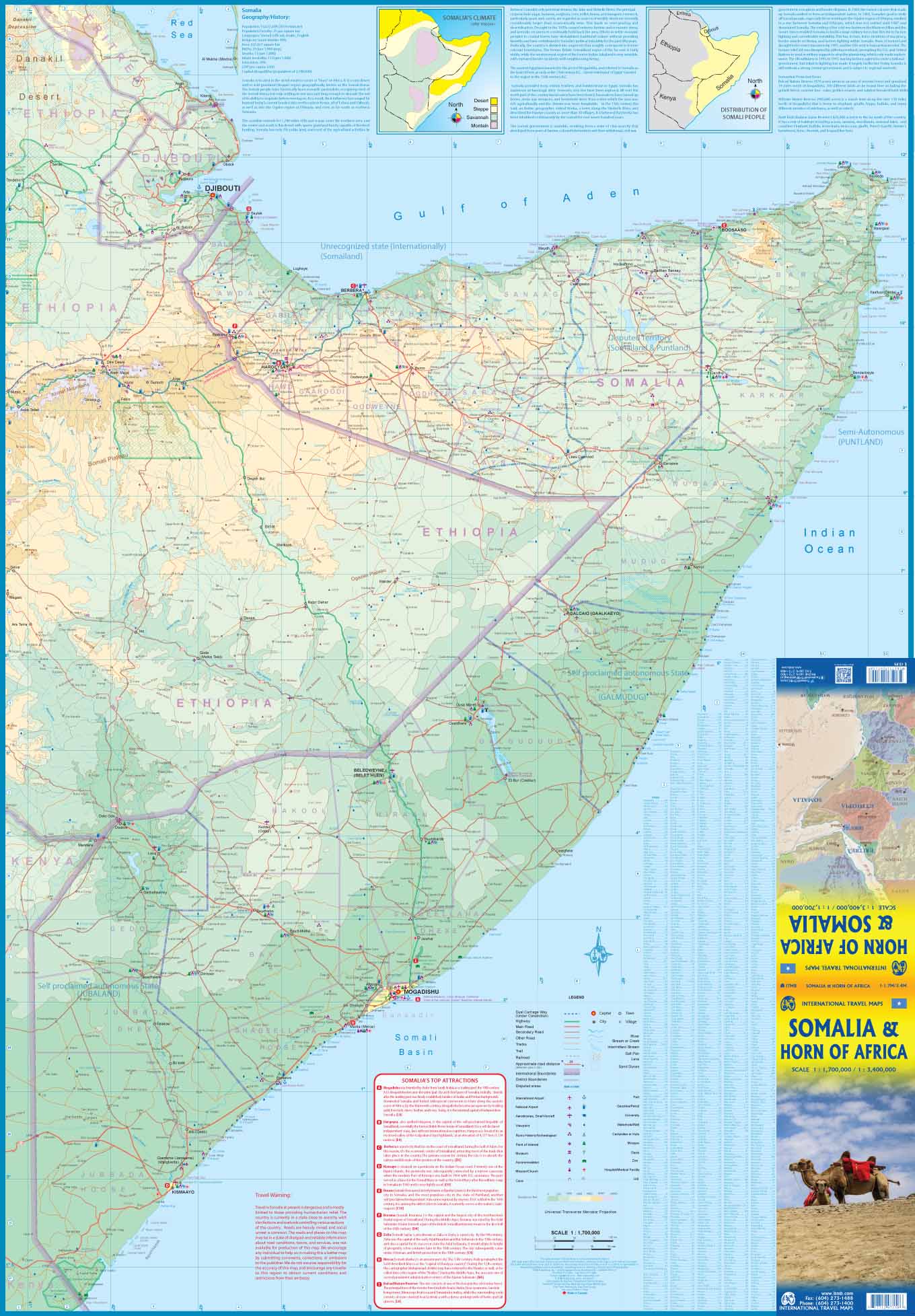
The Kavango–Zambezi Transfrontier Conservation Area (KAZA) is the largest transboundary conservation landscape on Earth — spanning Angola, Botswana, Namibia, Zambia and Zimbabwe across more than 519,000 km². This purpose-built Tracks4Africa map brings that vast wilderness into one coherent view, giving self-drive travellers and overlanders a powerful planning tool for Southern Africa’s most iconic safari region.
From the floodplains of the Okavango Delta to the thunder of Mosi-oa-Tunya (Victoria Falls) and the ancient rock art at Tsodilo Hills, this map captures the heart of wild Africa — with routes, distances and practical detail built from real GPS travel data.
🌍 Regional Extent — One Map, Five Countries
This edition stretches across the most compelling self-drive corridors in Southern Africa:
-
North: to Kafue National Park
-
South: toward Makgadikgadi National Park
-
West: beyond Windhoek
-
East: toward Lake Kariba
It links major parks and wildlife corridors including Chobe, Hwange, Bwabwata, Mudumu, Nkasa Rupara and more — revealing how ecosystems connect across borders.
⭐ What Makes This Map Different
🚙 Travel times & distances printed on the map — plan realistic daily stages
🛣️ Comprehensive road & track network — tar, gravel and remote 4×4 routes
🗺️ Regional overview at 1:1,000,000 scale — 1 cm ≈ 10 km
🛰️ Built from GPS travel data — aligned with Tracks4Africa navigation systems
🏕️ Touring highlights marked — river crossings, national parks, gateways and key hubs
💧 Printed on waterproof, tear-resistant PolyArt — expedition ready
This is a strategic planning map — ideal for designing multi-country routes before drilling down into country-level detail.
🐘 Safari, Wildlife & Big Landscapes
The KAZA region offers unmatched diversity:
-
The elephant herds of Chobe National Park
-
Predator country in Hwange
-
Mokoro journeys through the Okavango Delta
-
The vast plains of Kafue
-
Salt pans glowing at sunset in Makgadikgadi
-
Riverine birdlife across the Zambezi basin
Whether you’re chasing the Big 5, building a 600-species bird list, or simply floating at dusk on quiet floodwaters, KAZA delivers it all — and this map shows how it connects.
🧭 Practical Overland Advantages
KAZA is a region of border crossings, remote fuel stops and varied road conditions. This map helps you:
✔️ Compare route alternatives across countries
✔️ Estimate fuel and daylight requirements
✔️ Understand distances between park gates and towns
✔️ Plan border crossings intelligently
✔️ Visualise how parks interlink across the region
For long-range expedition planning, nothing beats seeing the full landscape at once.
💪 Built for Real Conditions
Printed on PolyArt synthetic stock, this map is:
💧 Water resistant
🌞 Sun and heat tolerant
🏕️ Camp-table durable
🚙 Dashboard ready
It folds easily so you can focus on the section you’re navigating, then refold without tearing.
📐 Specifications
📏 Scale: 1 : 1,000,000
📄 Format: Folded regional sheet
💧 Material: Waterproof & tear-resistant PolyArt
🗺️ Coverage: Five-country KAZA TFCA region
🚗 Features: Travel times, distances, comprehensive track network
🎯 Who This Map Is For
🚙 4×4 overlanders crossing borders
🏕️ Self-drive safari travellers
🌍 Long-haul expedition planners
📍 Independent explorers mapping complex routes
🧭 Travellers who value paper reliability in remote Africa
If you’re planning to roam between river systems, deserts and wildlife corridors, this map gives you the confidence to do it properly.
📦 Important Ordering Note
This is an Order-on-Demand map.
🕒 Please allow up to 10 working days for delivery.
⭐ One of Africa’s Greatest Wilderness Regions — In One View
The Kavango–Zambezi region is immense, complex and magnificent. The Tracks4Africa KAZA Overlander Map distils that scale into a single, practical planning tool — helping you move confidently across five countries and some of the richest wildlife landscapes on Earth.
Unfold it. Trace your route. And let Africa open up before you.
Product Information
Product Information
Shipping & Returns
Shipping & Returns


Kavango - Zambezi - Traks4Africa Map
Kavango - Zambezi - Traks4Africa Map
Kavango–Zambezi (KAZA) — Tracks4Africa Overlander Map
Scale 1 : 1,000,000 | Waterproof PolyArt | Five-Nation Safari Region
🐘 Okavango • Chobe • Victoria Falls • Kafue • Makgadikgadi
The Kavango–Zambezi Transfrontier Conservation Area (KAZA) is the largest transboundary conservation landscape on Earth — spanning Angola, Botswana, Namibia, Zambia and Zimbabwe across more than 519,000 km². This purpose-built Tracks4Africa map brings that vast wilderness into one coherent view, giving self-drive travellers and overlanders a powerful planning tool for Southern Africa’s most iconic safari region.
From the floodplains of the Okavango Delta to the thunder of Mosi-oa-Tunya (Victoria Falls) and the ancient rock art at Tsodilo Hills, this map captures the heart of wild Africa — with routes, distances and practical detail built from real GPS travel data.
🌍 Regional Extent — One Map, Five Countries
This edition stretches across the most compelling self-drive corridors in Southern Africa:
-
North: to Kafue National Park
-
South: toward Makgadikgadi National Park
-
West: beyond Windhoek
-
East: toward Lake Kariba
It links major parks and wildlife corridors including Chobe, Hwange, Bwabwata, Mudumu, Nkasa Rupara and more — revealing how ecosystems connect across borders.
⭐ What Makes This Map Different
🚙 Travel times & distances printed on the map — plan realistic daily stages
🛣️ Comprehensive road & track network — tar, gravel and remote 4×4 routes
🗺️ Regional overview at 1:1,000,000 scale — 1 cm ≈ 10 km
🛰️ Built from GPS travel data — aligned with Tracks4Africa navigation systems
🏕️ Touring highlights marked — river crossings, national parks, gateways and key hubs
💧 Printed on waterproof, tear-resistant PolyArt — expedition ready
This is a strategic planning map — ideal for designing multi-country routes before drilling down into country-level detail.
🐘 Safari, Wildlife & Big Landscapes
The KAZA region offers unmatched diversity:
-
The elephant herds of Chobe National Park
-
Predator country in Hwange
-
Mokoro journeys through the Okavango Delta
-
The vast plains of Kafue
-
Salt pans glowing at sunset in Makgadikgadi
-
Riverine birdlife across the Zambezi basin
Whether you’re chasing the Big 5, building a 600-species bird list, or simply floating at dusk on quiet floodwaters, KAZA delivers it all — and this map shows how it connects.
🧭 Practical Overland Advantages
KAZA is a region of border crossings, remote fuel stops and varied road conditions. This map helps you:
✔️ Compare route alternatives across countries
✔️ Estimate fuel and daylight requirements
✔️ Understand distances between park gates and towns
✔️ Plan border crossings intelligently
✔️ Visualise how parks interlink across the region
For long-range expedition planning, nothing beats seeing the full landscape at once.
💪 Built for Real Conditions
Printed on PolyArt synthetic stock, this map is:
💧 Water resistant
🌞 Sun and heat tolerant
🏕️ Camp-table durable
🚙 Dashboard ready
It folds easily so you can focus on the section you’re navigating, then refold without tearing.
📐 Specifications
📏 Scale: 1 : 1,000,000
📄 Format: Folded regional sheet
💧 Material: Waterproof & tear-resistant PolyArt
🗺️ Coverage: Five-country KAZA TFCA region
🚗 Features: Travel times, distances, comprehensive track network
🎯 Who This Map Is For
🚙 4×4 overlanders crossing borders
🏕️ Self-drive safari travellers
🌍 Long-haul expedition planners
📍 Independent explorers mapping complex routes
🧭 Travellers who value paper reliability in remote Africa
If you’re planning to roam between river systems, deserts and wildlife corridors, this map gives you the confidence to do it properly.
📦 Important Ordering Note
This is an Order-on-Demand map.
🕒 Please allow up to 10 working days for delivery.
⭐ One of Africa’s Greatest Wilderness Regions — In One View
The Kavango–Zambezi region is immense, complex and magnificent. The Tracks4Africa KAZA Overlander Map distils that scale into a single, practical planning tool — helping you move confidently across five countries and some of the richest wildlife landscapes on Earth.
Unfold it. Trace your route. And let Africa open up before you.
Original: $49.95
-70%$49.95
$14.98Product Information
Product Information
Shipping & Returns
Shipping & Returns
Description
Kavango–Zambezi (KAZA) — Tracks4Africa Overlander Map
Scale 1 : 1,000,000 | Waterproof PolyArt | Five-Nation Safari Region
🐘 Okavango • Chobe • Victoria Falls • Kafue • Makgadikgadi
The Kavango–Zambezi Transfrontier Conservation Area (KAZA) is the largest transboundary conservation landscape on Earth — spanning Angola, Botswana, Namibia, Zambia and Zimbabwe across more than 519,000 km². This purpose-built Tracks4Africa map brings that vast wilderness into one coherent view, giving self-drive travellers and overlanders a powerful planning tool for Southern Africa’s most iconic safari region.
From the floodplains of the Okavango Delta to the thunder of Mosi-oa-Tunya (Victoria Falls) and the ancient rock art at Tsodilo Hills, this map captures the heart of wild Africa — with routes, distances and practical detail built from real GPS travel data.
🌍 Regional Extent — One Map, Five Countries
This edition stretches across the most compelling self-drive corridors in Southern Africa:
-
North: to Kafue National Park
-
South: toward Makgadikgadi National Park
-
West: beyond Windhoek
-
East: toward Lake Kariba
It links major parks and wildlife corridors including Chobe, Hwange, Bwabwata, Mudumu, Nkasa Rupara and more — revealing how ecosystems connect across borders.
⭐ What Makes This Map Different
🚙 Travel times & distances printed on the map — plan realistic daily stages
🛣️ Comprehensive road & track network — tar, gravel and remote 4×4 routes
🗺️ Regional overview at 1:1,000,000 scale — 1 cm ≈ 10 km
🛰️ Built from GPS travel data — aligned with Tracks4Africa navigation systems
🏕️ Touring highlights marked — river crossings, national parks, gateways and key hubs
💧 Printed on waterproof, tear-resistant PolyArt — expedition ready
This is a strategic planning map — ideal for designing multi-country routes before drilling down into country-level detail.
🐘 Safari, Wildlife & Big Landscapes
The KAZA region offers unmatched diversity:
-
The elephant herds of Chobe National Park
-
Predator country in Hwange
-
Mokoro journeys through the Okavango Delta
-
The vast plains of Kafue
-
Salt pans glowing at sunset in Makgadikgadi
-
Riverine birdlife across the Zambezi basin
Whether you’re chasing the Big 5, building a 600-species bird list, or simply floating at dusk on quiet floodwaters, KAZA delivers it all — and this map shows how it connects.
🧭 Practical Overland Advantages
KAZA is a region of border crossings, remote fuel stops and varied road conditions. This map helps you:
✔️ Compare route alternatives across countries
✔️ Estimate fuel and daylight requirements
✔️ Understand distances between park gates and towns
✔️ Plan border crossings intelligently
✔️ Visualise how parks interlink across the region
For long-range expedition planning, nothing beats seeing the full landscape at once.
💪 Built for Real Conditions
Printed on PolyArt synthetic stock, this map is:
💧 Water resistant
🌞 Sun and heat tolerant
🏕️ Camp-table durable
🚙 Dashboard ready
It folds easily so you can focus on the section you’re navigating, then refold without tearing.
📐 Specifications
📏 Scale: 1 : 1,000,000
📄 Format: Folded regional sheet
💧 Material: Waterproof & tear-resistant PolyArt
🗺️ Coverage: Five-country KAZA TFCA region
🚗 Features: Travel times, distances, comprehensive track network
🎯 Who This Map Is For
🚙 4×4 overlanders crossing borders
🏕️ Self-drive safari travellers
🌍 Long-haul expedition planners
📍 Independent explorers mapping complex routes
🧭 Travellers who value paper reliability in remote Africa
If you’re planning to roam between river systems, deserts and wildlife corridors, this map gives you the confidence to do it properly.
📦 Important Ordering Note
This is an Order-on-Demand map.
🕒 Please allow up to 10 working days for delivery.
⭐ One of Africa’s Greatest Wilderness Regions — In One View
The Kavango–Zambezi region is immense, complex and magnificent. The Tracks4Africa KAZA Overlander Map distils that scale into a single, practical planning tool — helping you move confidently across five countries and some of the richest wildlife landscapes on Earth.
Unfold it. Trace your route. And let Africa open up before you.