Mid North South Australia Carto Graphics Map (Heysen Trail)
🥾 Mid North South Australia Touring Map – Carto Graphics
Featuring the Heysen Trail, Clare Valley, Mount Remarkable & More
Scale: 1:240,000 & 1:50,000 | Size: 1010 × 690 mm
🗺️ Now available in both folded paper and laminated versions
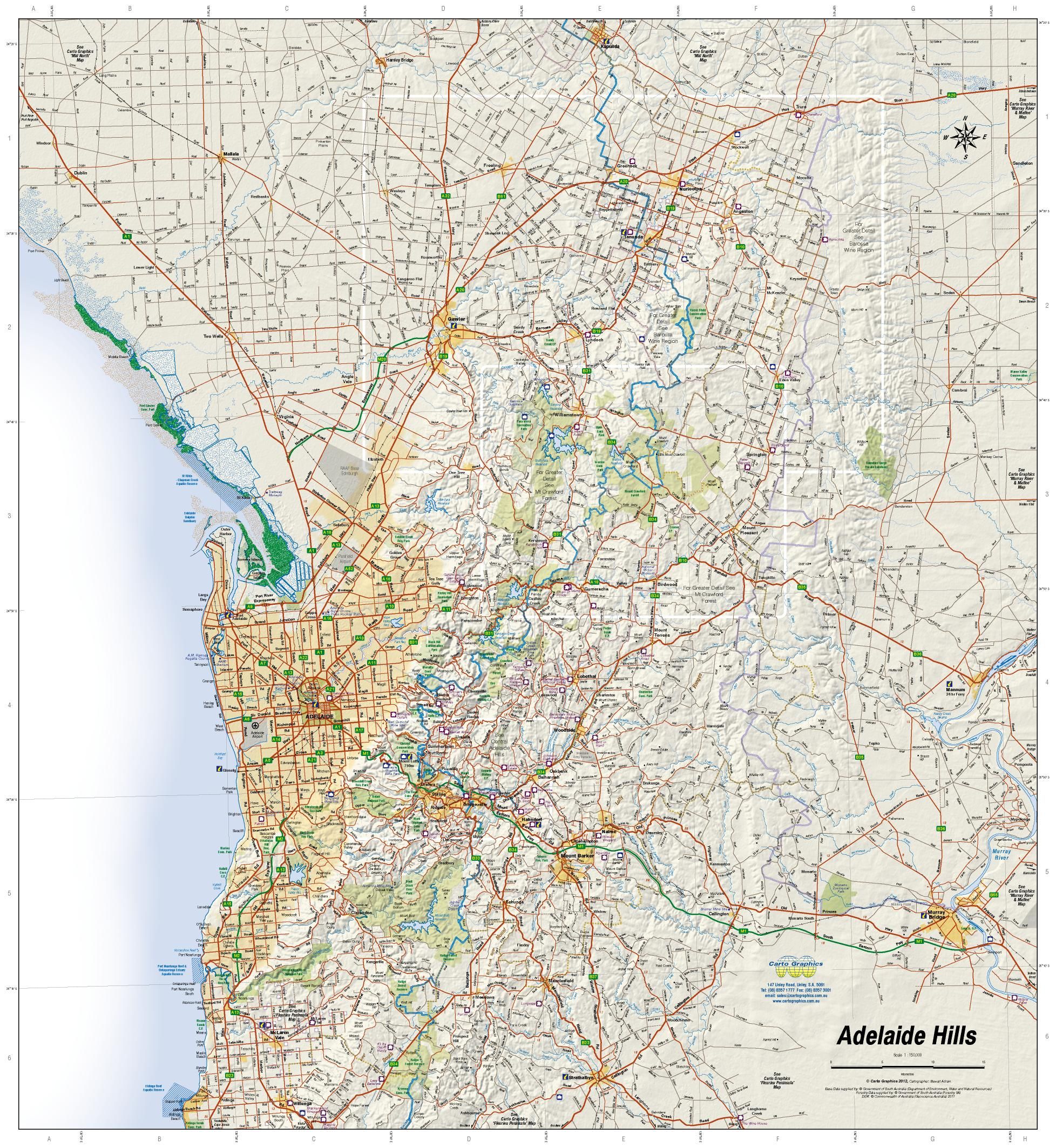
Discover the natural beauty, walking trails, and wine country of South Australia's Mid North with this detailed and highly practical touring map from Carto Graphics. Designed for adventurers, walkers, wine lovers, and regional travellers, this map provides comprehensive coverage from the outback town of Quorn in the north to Kapunda in the south, and from Burra in the east to the Spencer Gulf in the west.
This map is particularly useful for planning and navigating popular trails such as the Heysen Trail, Mawson Trail, and the Riesling Trail, along with enjoying the cellar doors and attractions of the Clare Valley.
🧭 Coverage Area
| Direction | Coverage |
|---|---|
| North | Quorn |
| South | Kapunda |
| East | Burra & Eudunda |
| West | Spencer Gulf coastline |
🚶 Walking & Touring Trails Marked
-
🥾 Heysen Trail – iconic 1200 km long-distance walking trail
-
🚴 Mawson Trail – premier off-road cycling trail through regional SA
-
🍇 Riesling Trail – scenic wine trail between Auburn and Clare
🗺️ Reverse Side Insets
The reverse side includes detailed topographic and regional maps:
-
🍷 Clare Valley Wine Region – cellar doors, trail access, towns
-
🏞️ Mount Remarkable National Park – walking tracks and camping
-
🌲 Bundaleer Forest & Wirrabara Forest – forest drives, picnic sites, and trailheads
🔍 Key Map Features
| ✅ Feature | 📍 Description |
|---|---|
| 🏘️ Town & Locality Index | Quickly locate towns and small communities |
| 🌳 National & Conservation Parks | Clearly shaded and named |
| 🛤️ Trails | All major walking and cycling trails marked |
| 🏕️ Camping & Caravan Parks | Easily find overnight options |
| 🍷 Wineries | Cellar doors marked across the wine region |
| 🏞️ Lookouts & Picnic Areas | Perfect for scenic stops |
| ℹ️ Info Centres & Ranger Stations | Visitor services and safety contacts included |
📐 Specifications
| Property | Detail |
|---|---|
| Title | Mid North South Australia Map |
| Publisher | Carto Graphics |
| Scales | 1:240,000 (main) and 1:50,000 (insets) |
| Format | Folded paper map OR laminated flat map |
| Flat Size | 1010 mm (W) × 690 mm (H) |
| Printed in | Australia |
🧱 Optional Laminated Version
Prefer something more durable for field use or wall display?
Choose our laminated flat version, which is:
-
🧴 Encapsulated in 80-micron gloss laminate for maximum durability
-
✍️ Whiteboard marker-friendly – plan routes, mark stops, or highlight trails
-
💧 Water-resistant and tear-resistant – perfect for the car, pack, or planning table
🔔 Note: The laminated version is flattened from the original folded map. Slight fold lines may still be visible.
🧳 Perfect For:
-
🥾 Hikers on the Heysen Trail or exploring Mount Remarkable
-
🚴 Cyclists touring the Mawson Trail or Clare Valley
-
🍷 Wine lovers discovering cellar doors in SA’s top boutique region
-
🏕️ Campers and caravanners exploring parks and forest reserves
-
📦 Regional business travellers and local delivery planning
-
🎒 Students, educators, or regional tourism professionals
🛒 Add to Cart – Plan, Explore, and Discover the Best of the Mid North
From forest reserves to rolling vineyards and remote outposts, the Mid North South Australia Map gives you the clarity and detail needed to make the most of your trip. Choose your preferred format before checkout:
-
✅ Folded Paper Map – perfect for glovebox or backpack
-
✅ Flat Laminated Map – ideal for field use, study, or wall display
Product Information
Product Information
Shipping & Returns
Shipping & Returns


Mid North South Australia Carto Graphics Map (Heysen Trail)
Mid North South Australia Carto Graphics Map (Heysen Trail)
🥾 Mid North South Australia Touring Map – Carto Graphics
Featuring the Heysen Trail, Clare Valley, Mount Remarkable & More
Scale: 1:240,000 & 1:50,000 | Size: 1010 × 690 mm
🗺️ Now available in both folded paper and laminated versions
Discover the natural beauty, walking trails, and wine country of South Australia's Mid North with this detailed and highly practical touring map from Carto Graphics. Designed for adventurers, walkers, wine lovers, and regional travellers, this map provides comprehensive coverage from the outback town of Quorn in the north to Kapunda in the south, and from Burra in the east to the Spencer Gulf in the west.
This map is particularly useful for planning and navigating popular trails such as the Heysen Trail, Mawson Trail, and the Riesling Trail, along with enjoying the cellar doors and attractions of the Clare Valley.
🧭 Coverage Area
| Direction | Coverage |
|---|---|
| North | Quorn |
| South | Kapunda |
| East | Burra & Eudunda |
| West | Spencer Gulf coastline |
🚶 Walking & Touring Trails Marked
-
🥾 Heysen Trail – iconic 1200 km long-distance walking trail
-
🚴 Mawson Trail – premier off-road cycling trail through regional SA
-
🍇 Riesling Trail – scenic wine trail between Auburn and Clare
🗺️ Reverse Side Insets
The reverse side includes detailed topographic and regional maps:
-
🍷 Clare Valley Wine Region – cellar doors, trail access, towns
-
🏞️ Mount Remarkable National Park – walking tracks and camping
-
🌲 Bundaleer Forest & Wirrabara Forest – forest drives, picnic sites, and trailheads
🔍 Key Map Features
| ✅ Feature | 📍 Description |
|---|---|
| 🏘️ Town & Locality Index | Quickly locate towns and small communities |
| 🌳 National & Conservation Parks | Clearly shaded and named |
| 🛤️ Trails | All major walking and cycling trails marked |
| 🏕️ Camping & Caravan Parks | Easily find overnight options |
| 🍷 Wineries | Cellar doors marked across the wine region |
| 🏞️ Lookouts & Picnic Areas | Perfect for scenic stops |
| ℹ️ Info Centres & Ranger Stations | Visitor services and safety contacts included |
📐 Specifications
| Property | Detail |
|---|---|
| Title | Mid North South Australia Map |
| Publisher | Carto Graphics |
| Scales | 1:240,000 (main) and 1:50,000 (insets) |
| Format | Folded paper map OR laminated flat map |
| Flat Size | 1010 mm (W) × 690 mm (H) |
| Printed in | Australia |
🧱 Optional Laminated Version
Prefer something more durable for field use or wall display?
Choose our laminated flat version, which is:
-
🧴 Encapsulated in 80-micron gloss laminate for maximum durability
-
✍️ Whiteboard marker-friendly – plan routes, mark stops, or highlight trails
-
💧 Water-resistant and tear-resistant – perfect for the car, pack, or planning table
🔔 Note: The laminated version is flattened from the original folded map. Slight fold lines may still be visible.
🧳 Perfect For:
-
🥾 Hikers on the Heysen Trail or exploring Mount Remarkable
-
🚴 Cyclists touring the Mawson Trail or Clare Valley
-
🍷 Wine lovers discovering cellar doors in SA’s top boutique region
-
🏕️ Campers and caravanners exploring parks and forest reserves
-
📦 Regional business travellers and local delivery planning
-
🎒 Students, educators, or regional tourism professionals
🛒 Add to Cart – Plan, Explore, and Discover the Best of the Mid North
From forest reserves to rolling vineyards and remote outposts, the Mid North South Australia Map gives you the clarity and detail needed to make the most of your trip. Choose your preferred format before checkout:
-
✅ Folded Paper Map – perfect for glovebox or backpack
-
✅ Flat Laminated Map – ideal for field use, study, or wall display
Original: $11.95
-70%$11.95
$3.58Product Information
Product Information
Shipping & Returns
Shipping & Returns
Description
🥾 Mid North South Australia Touring Map – Carto Graphics
Featuring the Heysen Trail, Clare Valley, Mount Remarkable & More
Scale: 1:240,000 & 1:50,000 | Size: 1010 × 690 mm
🗺️ Now available in both folded paper and laminated versions
Discover the natural beauty, walking trails, and wine country of South Australia's Mid North with this detailed and highly practical touring map from Carto Graphics. Designed for adventurers, walkers, wine lovers, and regional travellers, this map provides comprehensive coverage from the outback town of Quorn in the north to Kapunda in the south, and from Burra in the east to the Spencer Gulf in the west.
This map is particularly useful for planning and navigating popular trails such as the Heysen Trail, Mawson Trail, and the Riesling Trail, along with enjoying the cellar doors and attractions of the Clare Valley.
🧭 Coverage Area
| Direction | Coverage |
|---|---|
| North | Quorn |
| South | Kapunda |
| East | Burra & Eudunda |
| West | Spencer Gulf coastline |
🚶 Walking & Touring Trails Marked
-
🥾 Heysen Trail – iconic 1200 km long-distance walking trail
-
🚴 Mawson Trail – premier off-road cycling trail through regional SA
-
🍇 Riesling Trail – scenic wine trail between Auburn and Clare
🗺️ Reverse Side Insets
The reverse side includes detailed topographic and regional maps:
-
🍷 Clare Valley Wine Region – cellar doors, trail access, towns
-
🏞️ Mount Remarkable National Park – walking tracks and camping
-
🌲 Bundaleer Forest & Wirrabara Forest – forest drives, picnic sites, and trailheads
🔍 Key Map Features
| ✅ Feature | 📍 Description |
|---|---|
| 🏘️ Town & Locality Index | Quickly locate towns and small communities |
| 🌳 National & Conservation Parks | Clearly shaded and named |
| 🛤️ Trails | All major walking and cycling trails marked |
| 🏕️ Camping & Caravan Parks | Easily find overnight options |
| 🍷 Wineries | Cellar doors marked across the wine region |
| 🏞️ Lookouts & Picnic Areas | Perfect for scenic stops |
| ℹ️ Info Centres & Ranger Stations | Visitor services and safety contacts included |
📐 Specifications
| Property | Detail |
|---|---|
| Title | Mid North South Australia Map |
| Publisher | Carto Graphics |
| Scales | 1:240,000 (main) and 1:50,000 (insets) |
| Format | Folded paper map OR laminated flat map |
| Flat Size | 1010 mm (W) × 690 mm (H) |
| Printed in | Australia |
🧱 Optional Laminated Version
Prefer something more durable for field use or wall display?
Choose our laminated flat version, which is:
-
🧴 Encapsulated in 80-micron gloss laminate for maximum durability
-
✍️ Whiteboard marker-friendly – plan routes, mark stops, or highlight trails
-
💧 Water-resistant and tear-resistant – perfect for the car, pack, or planning table
🔔 Note: The laminated version is flattened from the original folded map. Slight fold lines may still be visible.
🧳 Perfect For:
-
🥾 Hikers on the Heysen Trail or exploring Mount Remarkable
-
🚴 Cyclists touring the Mawson Trail or Clare Valley
-
🍷 Wine lovers discovering cellar doors in SA’s top boutique region
-
🏕️ Campers and caravanners exploring parks and forest reserves
-
📦 Regional business travellers and local delivery planning
-
🎒 Students, educators, or regional tourism professionals
🛒 Add to Cart – Plan, Explore, and Discover the Best of the Mid North
From forest reserves to rolling vineyards and remote outposts, the Mid North South Australia Map gives you the clarity and detail needed to make the most of your trip. Choose your preferred format before checkout:
-
✅ Folded Paper Map – perfect for glovebox or backpack
-
✅ Flat Laminated Map – ideal for field use, study, or wall display