South America Physical Atlas of the World, 11th Edition, National Geographic Wall Map
🌎 South America Physical – Atlas of the World, 11th Edition
Published: 2019 | Made in Australia
Available Formats: Paper • Laminated • Laminated with Hang Rails • Canvas • Canvas with Hang Rails
🗺 A Window into the Wild Heart of South America
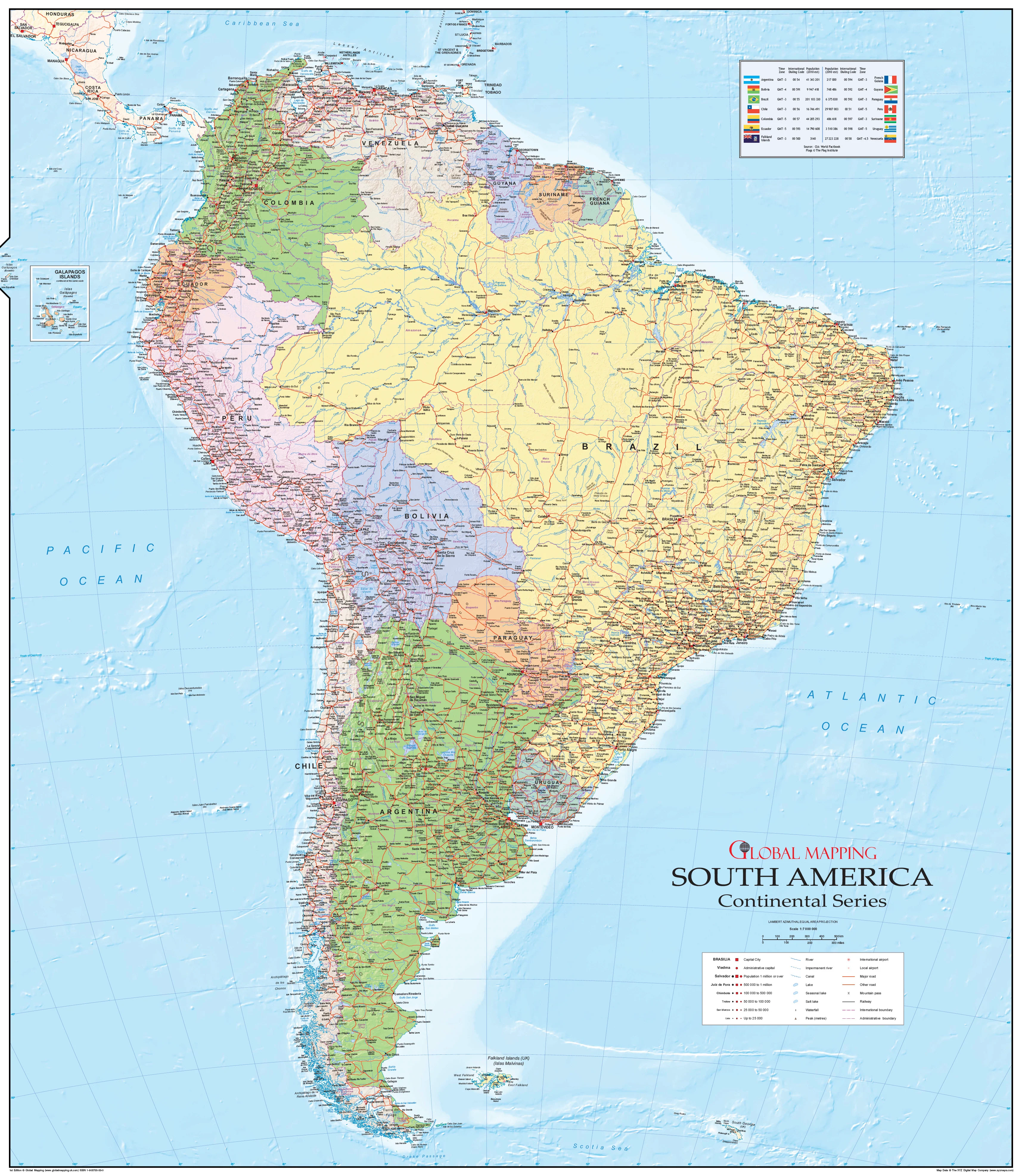
Imagine standing before the Andes, their snow-capped peaks piercing the sky, or drifting down the slow, sinuous course of the Amazon River as it winds through the greenest rainforest on Earth. The South America Physical Wall Map by National Geographic invites you to explore the continent in its purest form—untouched by political borders, letting the land itself tell the story.
Originally featured in National Geographic’s 11th Edition World Atlas, this map is a masterclass in cartographic artistry and geographic storytelling. Now available as a stand-alone wall display, it’s ready to inspire in classrooms, lecture halls, libraries, offices, and homes.
📐 Precision Cartography, National Geographic Style
This is more than a map—it’s an accurate and visually striking representation of South America’s landforms, printed using state-of-the-art cartographic techniques for exceptional clarity and depth.
Key features include:
-
True Physical Depiction – Mountains, valleys, deserts, rivers, and coastlines illustrated without political divisions.
-
Signature National Geographic Colour Palette – Bright blue oceans, vibrant landforms, and shaded relief bring the terrain to life.
-
Azimuthal Equidistant Projection – Ensures all locations are at proportionally correct distances from the map’s centre.
-
Meticulous Label Placement – Geographic names are positioned for optimal readability without clutter.
-
Highlighting Major Landforms – From the vast Pantanal wetlands to the Patagonian steppes.
🖌 Premium Printing & Display Options
Your map can be produced in a range of professional finishes to suit any purpose—whether it’s for teaching, collecting, or interior décor:
| Format | Best For | Details |
|---|---|---|
| Paper (160 gsm) | Framing | Heavyweight matte-coated paper, ideal for framing under glass. |
| Laminated | Frequent Handling | Fully encapsulated in 80-micron gloss laminate for long-lasting protection. |
| Laminated + Hang Rails | Ready-to-Hang | Lamination plus natural timber hang rails and hanging cord. |
| Canvas (395 gsm) | Premium Wall Art | Museum-grade matte canvas with archival pigment inks for rich, fade-resistant colour. |
| Canvas + Hang Rails | Statement Display | Canvas print mounted with timber hang rails for effortless installation. |
Note: Please allow 10 working days for delivery of hang-railed maps, as each is expertly mounted by our framer.
📏 Choose Your Perfect Size
This map is available in two sizes, giving you flexibility to fit it to your space:
| Size Name | Dimensions (mm) | Dimensions (inches) | Best For |
|---|---|---|---|
| Standard | 790 × 610 mm | 31.1 × 24.0 in | Home offices, study rooms, smaller classrooms. |
| Supermap | 1197 × 915 mm | 47.1 × 36.0 in | Large classrooms, libraries, boardrooms, and feature walls. |
💡 The Supermap option offers more geographic detail and an impressive visual impact in larger spaces.
🎯 Who This Map Is For
-
Educators – Bring lessons to life with a vibrant, large-format physical map.
-
Travellers & Explorers – Plan journeys and better understand the geography of this diverse continent.
-
Geography Enthusiasts – Own a piece of modern National Geographic cartography.
-
Interior Designers – Create a bold visual statement with a map that’s both educational and decorative.
✨ Why You’ll Love It
-
A modern National Geographic classic—crafted with 75+ years of cartographic heritage.
-
Printed with archival pigment-based inks for colour that stays true over decades.
-
Proudly made in Australia using sustainable, high-quality materials.
-
Available in multiple formats to match your purpose and space.
📍 Celebrate the untamed beauty of South America. Whether it’s hanging in a classroom to ignite curiosity, in a home to inspire travel, or in a boardroom to reflect global vision—this map is more than a display piece; it’s a conversation starter and a timeless work of art.
Product Information
Product Information
Shipping & Returns
Shipping & Returns

South America Physical Atlas of the World, 11th Edition, National Geographic Wall Map
South America Physical Atlas of the World, 11th Edition, National Geographic Wall Map
🌎 South America Physical – Atlas of the World, 11th Edition
Published: 2019 | Made in Australia
Available Formats: Paper • Laminated • Laminated with Hang Rails • Canvas • Canvas with Hang Rails
🗺 A Window into the Wild Heart of South America
Imagine standing before the Andes, their snow-capped peaks piercing the sky, or drifting down the slow, sinuous course of the Amazon River as it winds through the greenest rainforest on Earth. The South America Physical Wall Map by National Geographic invites you to explore the continent in its purest form—untouched by political borders, letting the land itself tell the story.
Originally featured in National Geographic’s 11th Edition World Atlas, this map is a masterclass in cartographic artistry and geographic storytelling. Now available as a stand-alone wall display, it’s ready to inspire in classrooms, lecture halls, libraries, offices, and homes.
📐 Precision Cartography, National Geographic Style
This is more than a map—it’s an accurate and visually striking representation of South America’s landforms, printed using state-of-the-art cartographic techniques for exceptional clarity and depth.
Key features include:
-
True Physical Depiction – Mountains, valleys, deserts, rivers, and coastlines illustrated without political divisions.
-
Signature National Geographic Colour Palette – Bright blue oceans, vibrant landforms, and shaded relief bring the terrain to life.
-
Azimuthal Equidistant Projection – Ensures all locations are at proportionally correct distances from the map’s centre.
-
Meticulous Label Placement – Geographic names are positioned for optimal readability without clutter.
-
Highlighting Major Landforms – From the vast Pantanal wetlands to the Patagonian steppes.
🖌 Premium Printing & Display Options
Your map can be produced in a range of professional finishes to suit any purpose—whether it’s for teaching, collecting, or interior décor:
| Format | Best For | Details |
|---|---|---|
| Paper (160 gsm) | Framing | Heavyweight matte-coated paper, ideal for framing under glass. |
| Laminated | Frequent Handling | Fully encapsulated in 80-micron gloss laminate for long-lasting protection. |
| Laminated + Hang Rails | Ready-to-Hang | Lamination plus natural timber hang rails and hanging cord. |
| Canvas (395 gsm) | Premium Wall Art | Museum-grade matte canvas with archival pigment inks for rich, fade-resistant colour. |
| Canvas + Hang Rails | Statement Display | Canvas print mounted with timber hang rails for effortless installation. |
Note: Please allow 10 working days for delivery of hang-railed maps, as each is expertly mounted by our framer.
📏 Choose Your Perfect Size
This map is available in two sizes, giving you flexibility to fit it to your space:
| Size Name | Dimensions (mm) | Dimensions (inches) | Best For |
|---|---|---|---|
| Standard | 790 × 610 mm | 31.1 × 24.0 in | Home offices, study rooms, smaller classrooms. |
| Supermap | 1197 × 915 mm | 47.1 × 36.0 in | Large classrooms, libraries, boardrooms, and feature walls. |
💡 The Supermap option offers more geographic detail and an impressive visual impact in larger spaces.
🎯 Who This Map Is For
-
Educators – Bring lessons to life with a vibrant, large-format physical map.
-
Travellers & Explorers – Plan journeys and better understand the geography of this diverse continent.
-
Geography Enthusiasts – Own a piece of modern National Geographic cartography.
-
Interior Designers – Create a bold visual statement with a map that’s both educational and decorative.
✨ Why You’ll Love It
-
A modern National Geographic classic—crafted with 75+ years of cartographic heritage.
-
Printed with archival pigment-based inks for colour that stays true over decades.
-
Proudly made in Australia using sustainable, high-quality materials.
-
Available in multiple formats to match your purpose and space.
📍 Celebrate the untamed beauty of South America. Whether it’s hanging in a classroom to ignite curiosity, in a home to inspire travel, or in a boardroom to reflect global vision—this map is more than a display piece; it’s a conversation starter and a timeless work of art.
Original: $69.95
-70%$69.95
$20.98Product Information
Product Information
Shipping & Returns
Shipping & Returns
Description
🌎 South America Physical – Atlas of the World, 11th Edition
Published: 2019 | Made in Australia
Available Formats: Paper • Laminated • Laminated with Hang Rails • Canvas • Canvas with Hang Rails
🗺 A Window into the Wild Heart of South America
Imagine standing before the Andes, their snow-capped peaks piercing the sky, or drifting down the slow, sinuous course of the Amazon River as it winds through the greenest rainforest on Earth. The South America Physical Wall Map by National Geographic invites you to explore the continent in its purest form—untouched by political borders, letting the land itself tell the story.
Originally featured in National Geographic’s 11th Edition World Atlas, this map is a masterclass in cartographic artistry and geographic storytelling. Now available as a stand-alone wall display, it’s ready to inspire in classrooms, lecture halls, libraries, offices, and homes.
📐 Precision Cartography, National Geographic Style
This is more than a map—it’s an accurate and visually striking representation of South America’s landforms, printed using state-of-the-art cartographic techniques for exceptional clarity and depth.
Key features include:
-
True Physical Depiction – Mountains, valleys, deserts, rivers, and coastlines illustrated without political divisions.
-
Signature National Geographic Colour Palette – Bright blue oceans, vibrant landforms, and shaded relief bring the terrain to life.
-
Azimuthal Equidistant Projection – Ensures all locations are at proportionally correct distances from the map’s centre.
-
Meticulous Label Placement – Geographic names are positioned for optimal readability without clutter.
-
Highlighting Major Landforms – From the vast Pantanal wetlands to the Patagonian steppes.
🖌 Premium Printing & Display Options
Your map can be produced in a range of professional finishes to suit any purpose—whether it’s for teaching, collecting, or interior décor:
| Format | Best For | Details |
|---|---|---|
| Paper (160 gsm) | Framing | Heavyweight matte-coated paper, ideal for framing under glass. |
| Laminated | Frequent Handling | Fully encapsulated in 80-micron gloss laminate for long-lasting protection. |
| Laminated + Hang Rails | Ready-to-Hang | Lamination plus natural timber hang rails and hanging cord. |
| Canvas (395 gsm) | Premium Wall Art | Museum-grade matte canvas with archival pigment inks for rich, fade-resistant colour. |
| Canvas + Hang Rails | Statement Display | Canvas print mounted with timber hang rails for effortless installation. |
Note: Please allow 10 working days for delivery of hang-railed maps, as each is expertly mounted by our framer.
📏 Choose Your Perfect Size
This map is available in two sizes, giving you flexibility to fit it to your space:
| Size Name | Dimensions (mm) | Dimensions (inches) | Best For |
|---|---|---|---|
| Standard | 790 × 610 mm | 31.1 × 24.0 in | Home offices, study rooms, smaller classrooms. |
| Supermap | 1197 × 915 mm | 47.1 × 36.0 in | Large classrooms, libraries, boardrooms, and feature walls. |
💡 The Supermap option offers more geographic detail and an impressive visual impact in larger spaces.
🎯 Who This Map Is For
-
Educators – Bring lessons to life with a vibrant, large-format physical map.
-
Travellers & Explorers – Plan journeys and better understand the geography of this diverse continent.
-
Geography Enthusiasts – Own a piece of modern National Geographic cartography.
-
Interior Designers – Create a bold visual statement with a map that’s both educational and decorative.
✨ Why You’ll Love It
-
A modern National Geographic classic—crafted with 75+ years of cartographic heritage.
-
Printed with archival pigment-based inks for colour that stays true over decades.
-
Proudly made in Australia using sustainable, high-quality materials.
-
Available in multiple formats to match your purpose and space.
📍 Celebrate the untamed beauty of South America. Whether it’s hanging in a classroom to ignite curiosity, in a home to inspire travel, or in a boardroom to reflect global vision—this map is more than a display piece; it’s a conversation starter and a timeless work of art.