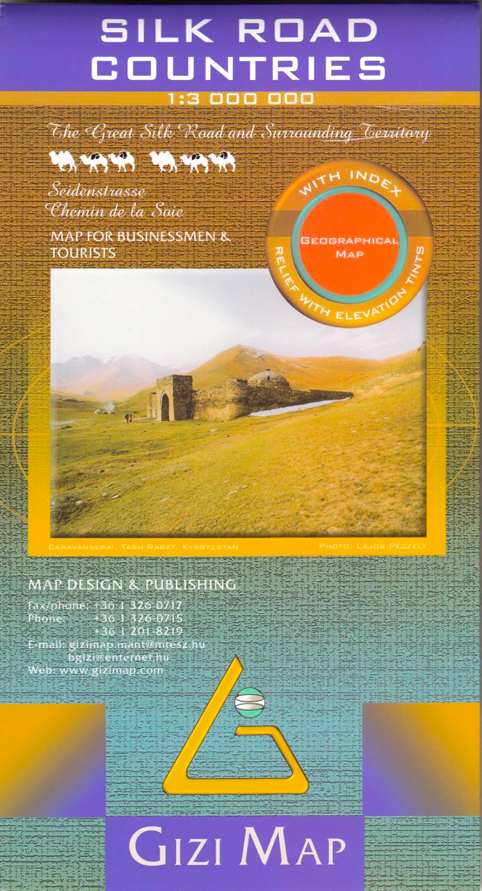
Silk Road Countries Gizi Maps Folded
🏺 Silk Road Countries Map – Gizi Maps
Folded Travel Map | One-sided | Includes Full Place Name Index on Reverse
🌍 Follow the Path of Empires, Trade, and Cultural Exchange
Step into the footsteps of ancient merchants, pilgrims, and conquerors with this Silk Road Countries Map by Gizi Maps—a unique and beautifully detailed reference that traces the legendary trade route from the eastern Mediterranean to western China.
This one-sided folded map captures the sweeping scale of the Silk Road, crossing deserts, mountains, and empires—ideal for historians, overland travellers, educators, and dreamers alike.
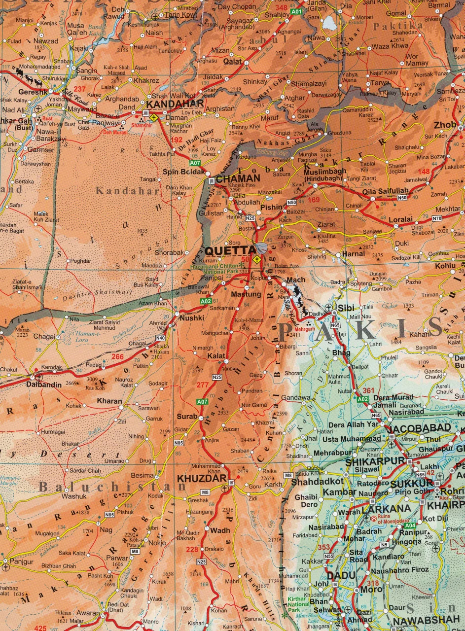
🗺️ Coverage Includes
| 📍 Regions Mapped |
|---|
| 🇹🇷 Turkey – Gateway to Asia and Europe |
| 🇸🇦 Saudi Arabia & 🇦🇪 United Arab Emirates – Important southern cultural routes |
| 🇮🇷 Iran, 🇮🇶 Iraq, 🇸🇾 Syria, 🇯🇴 Jordan – Ancient cities and caravan paths |
| 🇺🇿 Uzbekistan, 🇹🇲 Turkmenistan, 🇰🇿 Kazakhstan, 🇰🇬 Kyrgyzstan, 🇹🇯 Tajikistan – The heart of the Silk Road steppes and deserts |
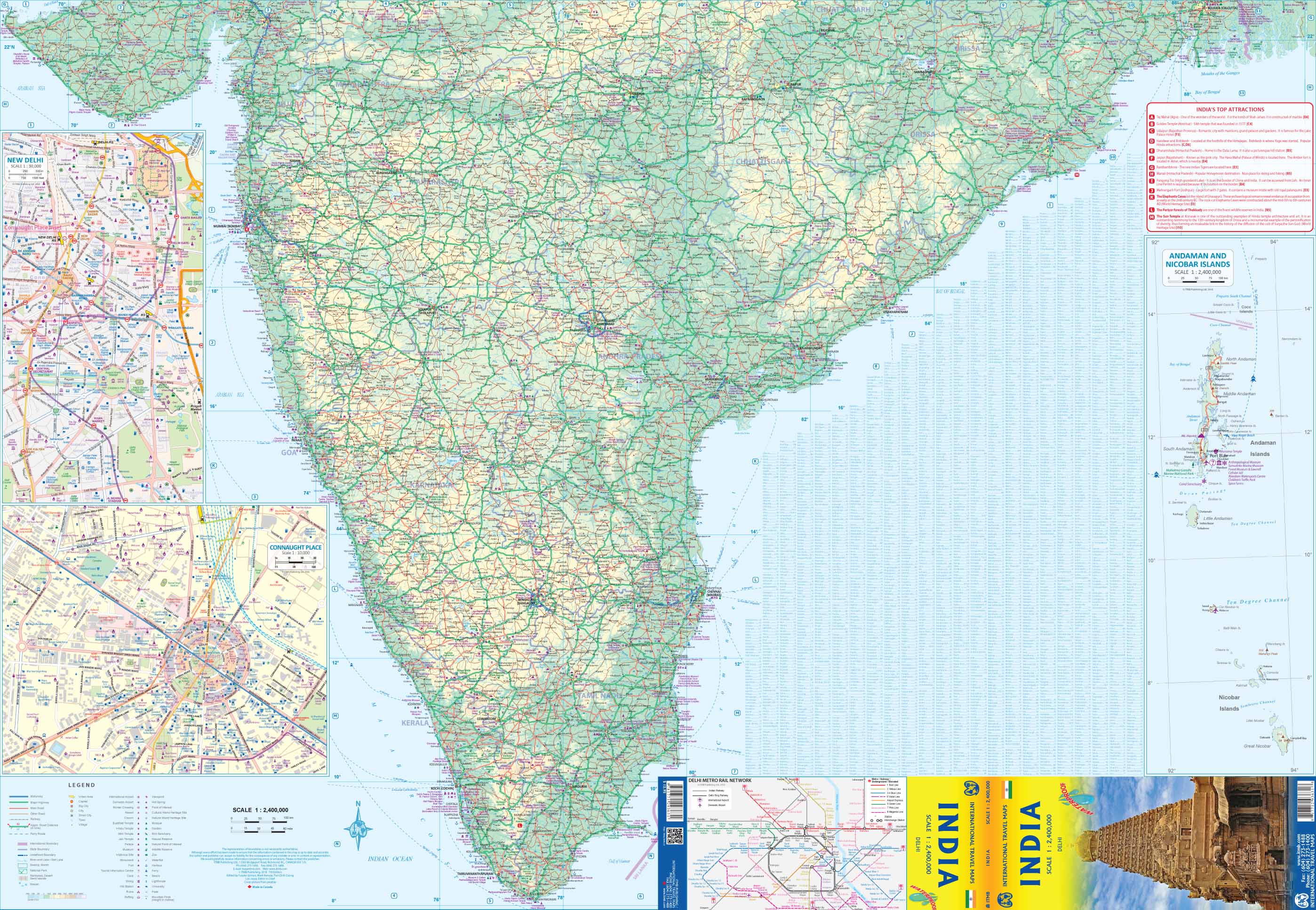
| 🇵🇰 Pakistan, 🇦🇫 Afghanistan, 🇮🇳 India, 🇳🇵 Nepal – Southern highland routes |
| 🇨🇳 Western China – Termination of the overland Silk Road in the cities of Xi’an and beyond |
🔍 Map Features
| 🌐 Feature | 📌 Details |
|---|---|
| Map Type | One-sided political & physical map |
| Reverse Side | Comprehensive place name index |
| Publisher | Gizi Maps (Budapest, Hungary) |
| Format | Folded, soft-laminated for durability |
| Edition | Latest available |
| Language | English place names |
| Coverage Span | From the Mediterranean to the Himalayas |
📌 Included Cartographic Details
-
🛣️ Roads, railways & key overland routes
-
🛳️ Seaports and major maritime connections
-
✈️ Airports and air corridors
-
🏛️ UNESCO World Heritage Sites & archaeological ruins
-
⛩️ Historic monuments and cultural landmarks
-
🌿 National parks and reserves
-
🐠 Coral reefs and coastal zones
-
🏜️ Physical geography including deserts, mountain ranges & rivers
🧭 This is more than just a road map—it's a cultural atlas connecting empires, religions, languages, and landscapes across 2,000+ years of history.
🎯 Perfect For
| 👤 Who It’s For | 🧭 Why It's Useful |
|---|---|
| Travellers & Overlanders | Plan epic cross-border adventures along ancient trade routes |
| Historians & Researchers | Trace key cities, kingdoms, and archaeological sites |
| Teachers & Students | Study the Silk Road’s geopolitical and cultural impact |
| Tour operators & travel planners | Design unique itineraries across multiple countries |
| Map collectors & enthusiasts | Own a rare and visually compelling regional map |
📦 Product Summary
| 🧾 Attribute | 📍 Specification |
|---|---|
| Title | Silk Road Countries Map |
| Publisher | Gizi Maps |
| Format | Folded, one-sided map |
| Index | Full place name index on reverse |
| Language | English |
| Dimensions | Approx. 690 mm x 1000 mm unfolded |
| ISBN | 9789638746685 |
🌟 Why Choose Gizi Maps?
-
Renowned for specialist regional coverage of historically rich areas
-
High-quality, colourful cartography that’s both informative and beautiful
-
Perfect balance between geopolitical accuracy and cultural depth
-
Designed for real-world use and armchair exploration alike
🛒 Begin Your Journey Through Time
Whether you’re travelling from Istanbul to Xi’an, studying the rise of Silk Road empires, or decorating your wall with something rich in meaning, the Silk Road Countries Map by Gizi Maps is an elegant and informative gateway to one of history’s most transformative trade networks.
Add to cart now and let the ancient routes unfold before you.
Product Information
Product Information
Shipping & Returns
Shipping & Returns


Silk Road Countries Gizi Maps Folded
Silk Road Countries Gizi Maps Folded
🏺 Silk Road Countries Map – Gizi Maps
Folded Travel Map | One-sided | Includes Full Place Name Index on Reverse
🌍 Follow the Path of Empires, Trade, and Cultural Exchange
Step into the footsteps of ancient merchants, pilgrims, and conquerors with this Silk Road Countries Map by Gizi Maps—a unique and beautifully detailed reference that traces the legendary trade route from the eastern Mediterranean to western China.
This one-sided folded map captures the sweeping scale of the Silk Road, crossing deserts, mountains, and empires—ideal for historians, overland travellers, educators, and dreamers alike.
🗺️ Coverage Includes
| 📍 Regions Mapped |
|---|
| 🇹🇷 Turkey – Gateway to Asia and Europe |
| 🇸🇦 Saudi Arabia & 🇦🇪 United Arab Emirates – Important southern cultural routes |
| 🇮🇷 Iran, 🇮🇶 Iraq, 🇸🇾 Syria, 🇯🇴 Jordan – Ancient cities and caravan paths |
| 🇺🇿 Uzbekistan, 🇹🇲 Turkmenistan, 🇰🇿 Kazakhstan, 🇰🇬 Kyrgyzstan, 🇹🇯 Tajikistan – The heart of the Silk Road steppes and deserts |
| 🇵🇰 Pakistan, 🇦🇫 Afghanistan, 🇮🇳 India, 🇳🇵 Nepal – Southern highland routes |
| 🇨🇳 Western China – Termination of the overland Silk Road in the cities of Xi’an and beyond |
🔍 Map Features
| 🌐 Feature | 📌 Details |
|---|---|
| Map Type | One-sided political & physical map |
| Reverse Side | Comprehensive place name index |
| Publisher | Gizi Maps (Budapest, Hungary) |
| Format | Folded, soft-laminated for durability |
| Edition | Latest available |
| Language | English place names |
| Coverage Span | From the Mediterranean to the Himalayas |
📌 Included Cartographic Details
-
🛣️ Roads, railways & key overland routes
-
🛳️ Seaports and major maritime connections
-
✈️ Airports and air corridors
-
🏛️ UNESCO World Heritage Sites & archaeological ruins
-
⛩️ Historic monuments and cultural landmarks
-
🌿 National parks and reserves
-
🐠 Coral reefs and coastal zones
-
🏜️ Physical geography including deserts, mountain ranges & rivers
🧭 This is more than just a road map—it's a cultural atlas connecting empires, religions, languages, and landscapes across 2,000+ years of history.
🎯 Perfect For
| 👤 Who It’s For | 🧭 Why It's Useful |
|---|---|
| Travellers & Overlanders | Plan epic cross-border adventures along ancient trade routes |
| Historians & Researchers | Trace key cities, kingdoms, and archaeological sites |
| Teachers & Students | Study the Silk Road’s geopolitical and cultural impact |
| Tour operators & travel planners | Design unique itineraries across multiple countries |
| Map collectors & enthusiasts | Own a rare and visually compelling regional map |
📦 Product Summary
| 🧾 Attribute | 📍 Specification |
|---|---|
| Title | Silk Road Countries Map |
| Publisher | Gizi Maps |
| Format | Folded, one-sided map |
| Index | Full place name index on reverse |
| Language | English |
| Dimensions | Approx. 690 mm x 1000 mm unfolded |
| ISBN | 9789638746685 |
🌟 Why Choose Gizi Maps?
-
Renowned for specialist regional coverage of historically rich areas
-
High-quality, colourful cartography that’s both informative and beautiful
-
Perfect balance between geopolitical accuracy and cultural depth
-
Designed for real-world use and armchair exploration alike
🛒 Begin Your Journey Through Time
Whether you’re travelling from Istanbul to Xi’an, studying the rise of Silk Road empires, or decorating your wall with something rich in meaning, the Silk Road Countries Map by Gizi Maps is an elegant and informative gateway to one of history’s most transformative trade networks.
Add to cart now and let the ancient routes unfold before you.
Original: $29.95
-70%$29.95
$8.98Product Information
Product Information
Shipping & Returns
Shipping & Returns
Description
🏺 Silk Road Countries Map – Gizi Maps
Folded Travel Map | One-sided | Includes Full Place Name Index on Reverse
🌍 Follow the Path of Empires, Trade, and Cultural Exchange
Step into the footsteps of ancient merchants, pilgrims, and conquerors with this Silk Road Countries Map by Gizi Maps—a unique and beautifully detailed reference that traces the legendary trade route from the eastern Mediterranean to western China.
This one-sided folded map captures the sweeping scale of the Silk Road, crossing deserts, mountains, and empires—ideal for historians, overland travellers, educators, and dreamers alike.
🗺️ Coverage Includes
| 📍 Regions Mapped |
|---|
| 🇹🇷 Turkey – Gateway to Asia and Europe |
| 🇸🇦 Saudi Arabia & 🇦🇪 United Arab Emirates – Important southern cultural routes |
| 🇮🇷 Iran, 🇮🇶 Iraq, 🇸🇾 Syria, 🇯🇴 Jordan – Ancient cities and caravan paths |
| 🇺🇿 Uzbekistan, 🇹🇲 Turkmenistan, 🇰🇿 Kazakhstan, 🇰🇬 Kyrgyzstan, 🇹🇯 Tajikistan – The heart of the Silk Road steppes and deserts |
| 🇵🇰 Pakistan, 🇦🇫 Afghanistan, 🇮🇳 India, 🇳🇵 Nepal – Southern highland routes |
| 🇨🇳 Western China – Termination of the overland Silk Road in the cities of Xi’an and beyond |
🔍 Map Features
| 🌐 Feature | 📌 Details |
|---|---|
| Map Type | One-sided political & physical map |
| Reverse Side | Comprehensive place name index |
| Publisher | Gizi Maps (Budapest, Hungary) |
| Format | Folded, soft-laminated for durability |
| Edition | Latest available |
| Language | English place names |
| Coverage Span | From the Mediterranean to the Himalayas |
📌 Included Cartographic Details
-
🛣️ Roads, railways & key overland routes
-
🛳️ Seaports and major maritime connections
-
✈️ Airports and air corridors
-
🏛️ UNESCO World Heritage Sites & archaeological ruins
-
⛩️ Historic monuments and cultural landmarks
-
🌿 National parks and reserves
-
🐠 Coral reefs and coastal zones
-
🏜️ Physical geography including deserts, mountain ranges & rivers
🧭 This is more than just a road map—it's a cultural atlas connecting empires, religions, languages, and landscapes across 2,000+ years of history.
🎯 Perfect For
| 👤 Who It’s For | 🧭 Why It's Useful |
|---|---|
| Travellers & Overlanders | Plan epic cross-border adventures along ancient trade routes |
| Historians & Researchers | Trace key cities, kingdoms, and archaeological sites |
| Teachers & Students | Study the Silk Road’s geopolitical and cultural impact |
| Tour operators & travel planners | Design unique itineraries across multiple countries |
| Map collectors & enthusiasts | Own a rare and visually compelling regional map |
📦 Product Summary
| 🧾 Attribute | 📍 Specification |
|---|---|
| Title | Silk Road Countries Map |
| Publisher | Gizi Maps |
| Format | Folded, one-sided map |
| Index | Full place name index on reverse |
| Language | English |
| Dimensions | Approx. 690 mm x 1000 mm unfolded |
| ISBN | 9789638746685 |
🌟 Why Choose Gizi Maps?
-
Renowned for specialist regional coverage of historically rich areas
-
High-quality, colourful cartography that’s both informative and beautiful
-
Perfect balance between geopolitical accuracy and cultural depth
-
Designed for real-world use and armchair exploration alike
🛒 Begin Your Journey Through Time
Whether you’re travelling from Istanbul to Xi’an, studying the rise of Silk Road empires, or decorating your wall with something rich in meaning, the Silk Road Countries Map by Gizi Maps is an elegant and informative gateway to one of history’s most transformative trade networks.
Add to cart now and let the ancient routes unfold before you.