Sydney & Region Touring Meridian Map
Scale: 1:500,000 | Optional Lamination | Road & 4WD Touring Edition
Covers National Parks, Forests, Campsites & Scenic Drives Across NSW
🏕️ Discover the Hidden Treasures of Sydney’s Surrounds
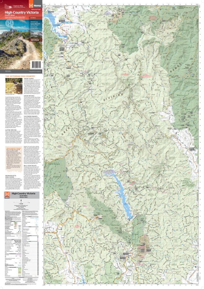
From the dense eucalypt forests of the Blue Mountains to the windswept beaches of the South Coast, Meridian Maps’ Sydney & Region Touring Map is your ultimate guide to adventuring beyond the city limits. Created for campers, 4WD explorers, caravaners, and day-trippers, this map reveals lesser-travelled routes and spectacular natural escapes in the greater Sydney region.
Whether you're planning a weekend escape, a multi-day overland journey, or a spontaneous forest detour, this beautifully detailed map makes it easy to find the roads less travelled — and the memories more unforgettable.
🗺️ Coverage & Regions
This large-format touring map covers a vast swathe of New South Wales:
-
🧭 North to Taree
-
🏖️ South beyond Batemans Bay
-
🏞️ West as far as Canberra and Orange
It's the perfect road companion for planning 4WD touring routes, camping trips, or scenic drives through forest reserves and national parks in every direction from Sydney.
🌲 Key Features
-
🚙 Designed for Road & 4WD Touring – Discover backroads, fire trails, and rugged forest tracks
-
🏕️ Campsites & Campgrounds Marked – Easily locate overnight stops in national parks and state forests
-
🗺️ Every National Park & State Forest Mapped – Explore with confidence, knowing what's protected and where to go
-
🧭 Tourist Features Included – Lookouts, picnic areas, walking trails, and attractions are all shown
-
🏞️ Scenic Routes Highlighted – Navigate some of NSW’s most stunning natural drives
With a scale of 1:500,000, this map strikes the perfect balance between regional overview and practical navigation — making it easy to plan a route while still showing the detail needed once you're on the trail.
✍️ Optional Lamination – Built for the Road
Upgrade to the laminated version for a reusable and rugged companion:
-
✅ Write-on/wipe-off surface – Use whiteboard markers to trace routes or make temporary notes
-
✅ Compatible with Map Dots – Great for marking campsites, trails, or favourite finds without permanent markings
-
✅ Tear- and stain-resistant – Ideal for outdoor use, in your vehicle or at the campsite
-
✅ Long-lasting – Withstands rough handling, folding, spills, and constant reference
🛠️ Note: Laminated maps are created from folded editions that have been professionally flattened and encapsulated in 80-micron gloss laminate. Some light fold lines may still be visible.
Who This Map Is For
-
🚐 Caravanners & Vanlifers – Plan and adapt routes across regional NSW with confidence
-
🚙 4WD & Overland Adventurers – Discover off-grid campsites, forest trails, and alternative routes
-
🏕️ Campers & Weekend Explorers – Know where to stay, stop, and rest along the way
-
🌲 Nature Lovers & Trail Walkers – Find tracks, forests, and lookout points beyond the typical trail maps
-
🧭 Touring Enthusiasts & Travel Planners – A must-have planning tool for spontaneous and long-haul journeys
📏 Product Specifications
| Feature | Description |
|---|---|
| Map Title | Sydney & Region Touring Map – Meridian Maps |
| Scale | 1:500,000 |
| Coverage Area | From Taree in the north to Batemans Bay in the south; west to Canberra & Orange |
| Map Type | Folded touring map with optional lamination |
| Laminated Option | Yes – Write-on/wipe-off, tear- and water-resistant |
| Included Features | National parks, forests, campsites, roads, 4WD routes, and tourist icons |
| Printed In | Australia 🇦🇺 |
🛒 Add to Cart Now
Ready to get off the grid and into the wild? The Sydney & Region Touring Map by Meridian Maps is your essential tool for exploring New South Wales’ most rewarding and remote destinations. Whether you’re in a 4WD, caravan, or hatchback, this map will help you plan your path — and discover the places others miss.
Add to cart today and make your next trip an unforgettable adventure.
Product Information
Product Information
Shipping & Returns
Shipping & Returns


Sydney & Region Touring Meridian Map
Sydney & Region Touring Meridian Map
Scale: 1:500,000 | Optional Lamination | Road & 4WD Touring Edition
Covers National Parks, Forests, Campsites & Scenic Drives Across NSW
🏕️ Discover the Hidden Treasures of Sydney’s Surrounds
From the dense eucalypt forests of the Blue Mountains to the windswept beaches of the South Coast, Meridian Maps’ Sydney & Region Touring Map is your ultimate guide to adventuring beyond the city limits. Created for campers, 4WD explorers, caravaners, and day-trippers, this map reveals lesser-travelled routes and spectacular natural escapes in the greater Sydney region.
Whether you're planning a weekend escape, a multi-day overland journey, or a spontaneous forest detour, this beautifully detailed map makes it easy to find the roads less travelled — and the memories more unforgettable.
🗺️ Coverage & Regions
This large-format touring map covers a vast swathe of New South Wales:
-
🧭 North to Taree
-
🏖️ South beyond Batemans Bay
-
🏞️ West as far as Canberra and Orange
It's the perfect road companion for planning 4WD touring routes, camping trips, or scenic drives through forest reserves and national parks in every direction from Sydney.
🌲 Key Features
-
🚙 Designed for Road & 4WD Touring – Discover backroads, fire trails, and rugged forest tracks
-
🏕️ Campsites & Campgrounds Marked – Easily locate overnight stops in national parks and state forests
-
🗺️ Every National Park & State Forest Mapped – Explore with confidence, knowing what's protected and where to go
-
🧭 Tourist Features Included – Lookouts, picnic areas, walking trails, and attractions are all shown
-
🏞️ Scenic Routes Highlighted – Navigate some of NSW’s most stunning natural drives
With a scale of 1:500,000, this map strikes the perfect balance between regional overview and practical navigation — making it easy to plan a route while still showing the detail needed once you're on the trail.
✍️ Optional Lamination – Built for the Road
Upgrade to the laminated version for a reusable and rugged companion:
-
✅ Write-on/wipe-off surface – Use whiteboard markers to trace routes or make temporary notes
-
✅ Compatible with Map Dots – Great for marking campsites, trails, or favourite finds without permanent markings
-
✅ Tear- and stain-resistant – Ideal for outdoor use, in your vehicle or at the campsite
-
✅ Long-lasting – Withstands rough handling, folding, spills, and constant reference
🛠️ Note: Laminated maps are created from folded editions that have been professionally flattened and encapsulated in 80-micron gloss laminate. Some light fold lines may still be visible.
Who This Map Is For
-
🚐 Caravanners & Vanlifers – Plan and adapt routes across regional NSW with confidence
-
🚙 4WD & Overland Adventurers – Discover off-grid campsites, forest trails, and alternative routes
-
🏕️ Campers & Weekend Explorers – Know where to stay, stop, and rest along the way
-
🌲 Nature Lovers & Trail Walkers – Find tracks, forests, and lookout points beyond the typical trail maps
-
🧭 Touring Enthusiasts & Travel Planners – A must-have planning tool for spontaneous and long-haul journeys
📏 Product Specifications
| Feature | Description |
|---|---|
| Map Title | Sydney & Region Touring Map – Meridian Maps |
| Scale | 1:500,000 |
| Coverage Area | From Taree in the north to Batemans Bay in the south; west to Canberra & Orange |
| Map Type | Folded touring map with optional lamination |
| Laminated Option | Yes – Write-on/wipe-off, tear- and water-resistant |
| Included Features | National parks, forests, campsites, roads, 4WD routes, and tourist icons |
| Printed In | Australia 🇦🇺 |
🛒 Add to Cart Now
Ready to get off the grid and into the wild? The Sydney & Region Touring Map by Meridian Maps is your essential tool for exploring New South Wales’ most rewarding and remote destinations. Whether you’re in a 4WD, caravan, or hatchback, this map will help you plan your path — and discover the places others miss.
Add to cart today and make your next trip an unforgettable adventure.
Original: $14.95
-70%$14.95
$4.48Product Information
Product Information
Shipping & Returns
Shipping & Returns
Description
Scale: 1:500,000 | Optional Lamination | Road & 4WD Touring Edition
Covers National Parks, Forests, Campsites & Scenic Drives Across NSW
🏕️ Discover the Hidden Treasures of Sydney’s Surrounds
From the dense eucalypt forests of the Blue Mountains to the windswept beaches of the South Coast, Meridian Maps’ Sydney & Region Touring Map is your ultimate guide to adventuring beyond the city limits. Created for campers, 4WD explorers, caravaners, and day-trippers, this map reveals lesser-travelled routes and spectacular natural escapes in the greater Sydney region.
Whether you're planning a weekend escape, a multi-day overland journey, or a spontaneous forest detour, this beautifully detailed map makes it easy to find the roads less travelled — and the memories more unforgettable.
🗺️ Coverage & Regions
This large-format touring map covers a vast swathe of New South Wales:
-
🧭 North to Taree
-
🏖️ South beyond Batemans Bay
-
🏞️ West as far as Canberra and Orange
It's the perfect road companion for planning 4WD touring routes, camping trips, or scenic drives through forest reserves and national parks in every direction from Sydney.
🌲 Key Features
-
🚙 Designed for Road & 4WD Touring – Discover backroads, fire trails, and rugged forest tracks
-
🏕️ Campsites & Campgrounds Marked – Easily locate overnight stops in national parks and state forests
-
🗺️ Every National Park & State Forest Mapped – Explore with confidence, knowing what's protected and where to go
-
🧭 Tourist Features Included – Lookouts, picnic areas, walking trails, and attractions are all shown
-
🏞️ Scenic Routes Highlighted – Navigate some of NSW’s most stunning natural drives
With a scale of 1:500,000, this map strikes the perfect balance between regional overview and practical navigation — making it easy to plan a route while still showing the detail needed once you're on the trail.
✍️ Optional Lamination – Built for the Road
Upgrade to the laminated version for a reusable and rugged companion:
-
✅ Write-on/wipe-off surface – Use whiteboard markers to trace routes or make temporary notes
-
✅ Compatible with Map Dots – Great for marking campsites, trails, or favourite finds without permanent markings
-
✅ Tear- and stain-resistant – Ideal for outdoor use, in your vehicle or at the campsite
-
✅ Long-lasting – Withstands rough handling, folding, spills, and constant reference
🛠️ Note: Laminated maps are created from folded editions that have been professionally flattened and encapsulated in 80-micron gloss laminate. Some light fold lines may still be visible.
Who This Map Is For
-
🚐 Caravanners & Vanlifers – Plan and adapt routes across regional NSW with confidence
-
🚙 4WD & Overland Adventurers – Discover off-grid campsites, forest trails, and alternative routes
-
🏕️ Campers & Weekend Explorers – Know where to stay, stop, and rest along the way
-
🌲 Nature Lovers & Trail Walkers – Find tracks, forests, and lookout points beyond the typical trail maps
-
🧭 Touring Enthusiasts & Travel Planners – A must-have planning tool for spontaneous and long-haul journeys
📏 Product Specifications
| Feature | Description |
|---|---|
| Map Title | Sydney & Region Touring Map – Meridian Maps |
| Scale | 1:500,000 |
| Coverage Area | From Taree in the north to Batemans Bay in the south; west to Canberra & Orange |
| Map Type | Folded touring map with optional lamination |
| Laminated Option | Yes – Write-on/wipe-off, tear- and water-resistant |
| Included Features | National parks, forests, campsites, roads, 4WD routes, and tourist icons |
| Printed In | Australia 🇦🇺 |
🛒 Add to Cart Now
Ready to get off the grid and into the wild? The Sydney & Region Touring Map by Meridian Maps is your essential tool for exploring New South Wales’ most rewarding and remote destinations. Whether you’re in a 4WD, caravan, or hatchback, this map will help you plan your path — and discover the places others miss.
Add to cart today and make your next trip an unforgettable adventure.