Tasmania Local Government Areas Wall Map
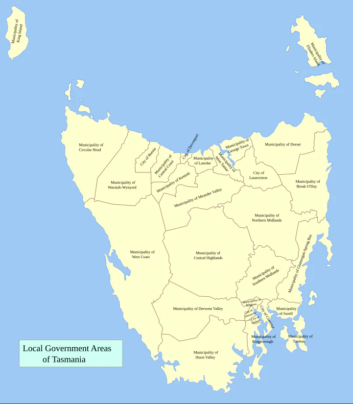
Tasmania Local Government Areas — Administrative Wall Map
1000 × 900 mm • Paper / Laminated / Laminated + Hang Rails / Canvas / Canvas + Hang Rails • Printed in Australia
A clear, wall-ready reference of every Local Government Area (LGA) in Tasmania—designed for councils, offices, classrooms, and planning spaces where boundaries and names need to be read with ease.
🧭 At a Glance (What’s on the Map)
-
All Tasmanian LGA boundaries & names presented with precision
-
Legend, neatline & scale bar for quick orientation
-
Island-wide context — every LGA shown within the Tasmanian state boundary
-
Readable labelling — crisp, uncluttered fonts sized for wall visibility
-
Contextual detail — coastline, neighbouring islands, and key waterways
🎯 Why This Map Works
-
Administrative clarity — instantly locate LGAs for planning, governance, and service delivery
-
Planning-ready — supports infrastructure, logistics, education, and healthcare zoning
-
Professional style — clean, cartographic finish ideal for offices and public display
-
Durable options — select laminate for hands-on use or canvas for a premium wall feature
👥 Who Uses It
-
Councils & State Government — planning, briefings, and community discussions
-
Utilities & Logistics — service areas, infrastructure management
-
Healthcare & Education — catchments, regional service allocation
-
Real Estate & Media — marketing territories, reporting regions
-
Libraries & Community Spaces — a practical reference for the public
🧩 Design Details
-
Boundary hierarchy — LGAs emphasised with state boundary reinforced
-
Legibility first — wall-readable typography and clear boundary styling
-
Balanced palette — separates LGAs without distracting colour clashes
-
Consistent cartography — legend, scale bar, and neatline aligned for ease of use
🎨 Finishes & Display Options
-
📄 Paper — Heavyweight 160 gsm (Matte)
Smooth, low-glare stock ideal for framing under glass. -
💧 Laminated — True Encapsulation
Printed on 120 gsm and sealed in 2 × 80-micron gloss laminate (edge-sealed).
Wipe-clean • Tear-resistant • Moisture-safe — suitable for non-permanent whiteboard markers and map dots. -
🪵 Laminated + Timber Hang Rails — Ready to Hang
Natural lacquered timber rails (top & bottom) with a top hanging cord for a professional, frame-free finish.
⏱️ Custom finish — please allow up to 10 working days for rail fitting. -
🖼️ Canvas — HP 395 gsm Professional Matte
Gallery-grade canvas printed with pigment-based, fade-resistant inks for lasting clarity. -
🪵 Canvas + Timber Hang Rails
Same premium canvas, finished with natural timber rails and top hanging cord.
⏱️ Custom finish — please allow up to 10 working days for rail fitting.
Dry-erase markers are recommended only on laminated versions.
📐 Specifications
| Attribute | Details |
|---|---|
| Title | Tasmania Local Government Areas — Administrative Wall Map |
| Coverage | Tasmania, Australia |
| Map Type | Administrative (Local Government Areas) |
| Size | 1000 mm (H) × 900 mm (W) |
| Scale | Not stated |
| Formats | Paper • Laminated • Laminated + Hang Rails • Canvas • Canvas + Hang Rails |
| Paper | 160 gsm matte |
| Laminate | 2 × 80-micron gloss, true encapsulation (edge-sealed) |
| Canvas | HP 395 gsm Professional Matte |
| Inks | Pigment-based, fade-resistant |
| Origin | Printed in Australia |
| Lead Time | Hang-railed finishes: up to 10 working days |
🧽 Mounting & Care
-
Laminated: Use non-permanent whiteboard markers; wipe with a dry microfibre cloth.
-
Paper: Frame under glass for best longevity.
-
Canvas: Dust lightly; avoid liquids and prolonged sunlight.
-
Hanging tip: For rail versions, hang from a central wall hook for balance.
🤝 Our Commitment
-
Australian made: Designed, printed, and finished locally.
-
High quality: Archival pigment inks and professional-grade materials.
-
Carefully packed: Hand-checked and shipped securely to arrive ready for display.
Put Tasmania’s LGAs into focus.
Choose your finish and add this essential administrative map to your wall.
Product Information
Product Information
Shipping & Returns
Shipping & Returns
Tasmania Local Government Areas Wall Map
Tasmania Local Government Areas Wall Map
Tasmania Local Government Areas — Administrative Wall Map
1000 × 900 mm • Paper / Laminated / Laminated + Hang Rails / Canvas / Canvas + Hang Rails • Printed in Australia
A clear, wall-ready reference of every Local Government Area (LGA) in Tasmania—designed for councils, offices, classrooms, and planning spaces where boundaries and names need to be read with ease.
🧭 At a Glance (What’s on the Map)
-
All Tasmanian LGA boundaries & names presented with precision
-
Legend, neatline & scale bar for quick orientation
-
Island-wide context — every LGA shown within the Tasmanian state boundary
-
Readable labelling — crisp, uncluttered fonts sized for wall visibility
-
Contextual detail — coastline, neighbouring islands, and key waterways
🎯 Why This Map Works
-
Administrative clarity — instantly locate LGAs for planning, governance, and service delivery
-
Planning-ready — supports infrastructure, logistics, education, and healthcare zoning
-
Professional style — clean, cartographic finish ideal for offices and public display
-
Durable options — select laminate for hands-on use or canvas for a premium wall feature
👥 Who Uses It
-
Councils & State Government — planning, briefings, and community discussions
-
Utilities & Logistics — service areas, infrastructure management
-
Healthcare & Education — catchments, regional service allocation
-
Real Estate & Media — marketing territories, reporting regions
-
Libraries & Community Spaces — a practical reference for the public
🧩 Design Details
-
Boundary hierarchy — LGAs emphasised with state boundary reinforced
-
Legibility first — wall-readable typography and clear boundary styling
-
Balanced palette — separates LGAs without distracting colour clashes
-
Consistent cartography — legend, scale bar, and neatline aligned for ease of use
🎨 Finishes & Display Options
-
📄 Paper — Heavyweight 160 gsm (Matte)
Smooth, low-glare stock ideal for framing under glass. -
💧 Laminated — True Encapsulation
Printed on 120 gsm and sealed in 2 × 80-micron gloss laminate (edge-sealed).
Wipe-clean • Tear-resistant • Moisture-safe — suitable for non-permanent whiteboard markers and map dots. -
🪵 Laminated + Timber Hang Rails — Ready to Hang
Natural lacquered timber rails (top & bottom) with a top hanging cord for a professional, frame-free finish.
⏱️ Custom finish — please allow up to 10 working days for rail fitting. -
🖼️ Canvas — HP 395 gsm Professional Matte
Gallery-grade canvas printed with pigment-based, fade-resistant inks for lasting clarity. -
🪵 Canvas + Timber Hang Rails
Same premium canvas, finished with natural timber rails and top hanging cord.
⏱️ Custom finish — please allow up to 10 working days for rail fitting.
Dry-erase markers are recommended only on laminated versions.
📐 Specifications
| Attribute | Details |
|---|---|
| Title | Tasmania Local Government Areas — Administrative Wall Map |
| Coverage | Tasmania, Australia |
| Map Type | Administrative (Local Government Areas) |
| Size | 1000 mm (H) × 900 mm (W) |
| Scale | Not stated |
| Formats | Paper • Laminated • Laminated + Hang Rails • Canvas • Canvas + Hang Rails |
| Paper | 160 gsm matte |
| Laminate | 2 × 80-micron gloss, true encapsulation (edge-sealed) |
| Canvas | HP 395 gsm Professional Matte |
| Inks | Pigment-based, fade-resistant |
| Origin | Printed in Australia |
| Lead Time | Hang-railed finishes: up to 10 working days |
🧽 Mounting & Care
-
Laminated: Use non-permanent whiteboard markers; wipe with a dry microfibre cloth.
-
Paper: Frame under glass for best longevity.
-
Canvas: Dust lightly; avoid liquids and prolonged sunlight.
-
Hanging tip: For rail versions, hang from a central wall hook for balance.
🤝 Our Commitment
-
Australian made: Designed, printed, and finished locally.
-
High quality: Archival pigment inks and professional-grade materials.
-
Carefully packed: Hand-checked and shipped securely to arrive ready for display.
Put Tasmania’s LGAs into focus.
Choose your finish and add this essential administrative map to your wall.
Original: $69.95
-70%$69.95
$20.98Product Information
Product Information
Shipping & Returns
Shipping & Returns
Description
Tasmania Local Government Areas — Administrative Wall Map
1000 × 900 mm • Paper / Laminated / Laminated + Hang Rails / Canvas / Canvas + Hang Rails • Printed in Australia
A clear, wall-ready reference of every Local Government Area (LGA) in Tasmania—designed for councils, offices, classrooms, and planning spaces where boundaries and names need to be read with ease.
🧭 At a Glance (What’s on the Map)
-
All Tasmanian LGA boundaries & names presented with precision
-
Legend, neatline & scale bar for quick orientation
-
Island-wide context — every LGA shown within the Tasmanian state boundary
-
Readable labelling — crisp, uncluttered fonts sized for wall visibility
-
Contextual detail — coastline, neighbouring islands, and key waterways
🎯 Why This Map Works
-
Administrative clarity — instantly locate LGAs for planning, governance, and service delivery
-
Planning-ready — supports infrastructure, logistics, education, and healthcare zoning
-
Professional style — clean, cartographic finish ideal for offices and public display
-
Durable options — select laminate for hands-on use or canvas for a premium wall feature
👥 Who Uses It
-
Councils & State Government — planning, briefings, and community discussions
-
Utilities & Logistics — service areas, infrastructure management
-
Healthcare & Education — catchments, regional service allocation
-
Real Estate & Media — marketing territories, reporting regions
-
Libraries & Community Spaces — a practical reference for the public
🧩 Design Details
-
Boundary hierarchy — LGAs emphasised with state boundary reinforced
-
Legibility first — wall-readable typography and clear boundary styling
-
Balanced palette — separates LGAs without distracting colour clashes
-
Consistent cartography — legend, scale bar, and neatline aligned for ease of use
🎨 Finishes & Display Options
-
📄 Paper — Heavyweight 160 gsm (Matte)
Smooth, low-glare stock ideal for framing under glass. -
💧 Laminated — True Encapsulation
Printed on 120 gsm and sealed in 2 × 80-micron gloss laminate (edge-sealed).
Wipe-clean • Tear-resistant • Moisture-safe — suitable for non-permanent whiteboard markers and map dots. -
🪵 Laminated + Timber Hang Rails — Ready to Hang
Natural lacquered timber rails (top & bottom) with a top hanging cord for a professional, frame-free finish.
⏱️ Custom finish — please allow up to 10 working days for rail fitting. -
🖼️ Canvas — HP 395 gsm Professional Matte
Gallery-grade canvas printed with pigment-based, fade-resistant inks for lasting clarity. -
🪵 Canvas + Timber Hang Rails
Same premium canvas, finished with natural timber rails and top hanging cord.
⏱️ Custom finish — please allow up to 10 working days for rail fitting.
Dry-erase markers are recommended only on laminated versions.
📐 Specifications
| Attribute | Details |
|---|---|
| Title | Tasmania Local Government Areas — Administrative Wall Map |
| Coverage | Tasmania, Australia |
| Map Type | Administrative (Local Government Areas) |
| Size | 1000 mm (H) × 900 mm (W) |
| Scale | Not stated |
| Formats | Paper • Laminated • Laminated + Hang Rails • Canvas • Canvas + Hang Rails |
| Paper | 160 gsm matte |
| Laminate | 2 × 80-micron gloss, true encapsulation (edge-sealed) |
| Canvas | HP 395 gsm Professional Matte |
| Inks | Pigment-based, fade-resistant |
| Origin | Printed in Australia |
| Lead Time | Hang-railed finishes: up to 10 working days |
🧽 Mounting & Care
-
Laminated: Use non-permanent whiteboard markers; wipe with a dry microfibre cloth.
-
Paper: Frame under glass for best longevity.
-
Canvas: Dust lightly; avoid liquids and prolonged sunlight.
-
Hanging tip: For rail versions, hang from a central wall hook for balance.
🤝 Our Commitment
-
Australian made: Designed, printed, and finished locally.
-
High quality: Archival pigment inks and professional-grade materials.
-
Carefully packed: Hand-checked and shipped securely to arrive ready for display.
Put Tasmania’s LGAs into focus.
Choose your finish and add this essential administrative map to your wall.


