The Grampians Peaks Trail Woodslane
The Grampians Peaks Trail — Gariwerd on Foot
🥾 Rugged Peaks • Knife-Edge Ridges • Ancient Country — One of Australia’s Great Walks
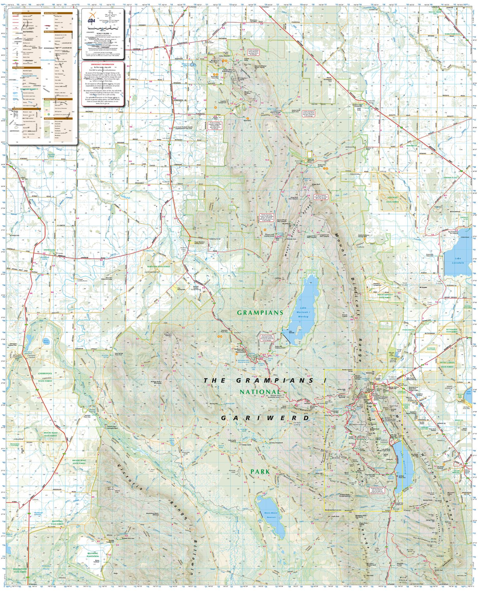
Rising dramatically from the western plains of Victoria, Grampians National Park — known to its Traditional Owners as Gariwerd — is a landscape of sandstone mountains, soaring escarpments and deep cultural meaning. The Grampians Peaks Trail is its defining journey: a 164-kilometre, north–south traverse from Mount Zero to Dunkeld, typically walked over 13 days / 12 nights.
The Grampians Peaks Trail, published by Woodslane Press, is the definitive, field-ready guide to this ambitious walk. It is written for hikers who want clarity, realism and respect for Country — whether you’re planning the full end-to-end experience or selecting standout sections for shorter adventures.
🌟 Why This Guide Is a Standout
This guide earns its reputation by treating the trail as a serious expedition, while remaining approachable and practical:
🥾 Complete end-to-end coverage — every section of the Grampians Peaks Trail clearly described
📏 Realistic planning detail — distances, daily elevation gain/loss, grades and achievable time estimates
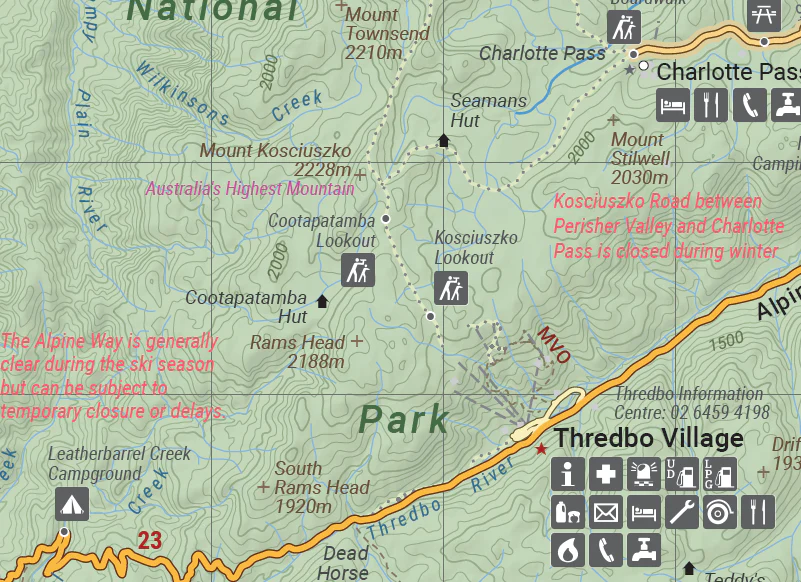
🗺️ Clear, field-ready full-colour maps — designed to be used in exposed, remote terrain
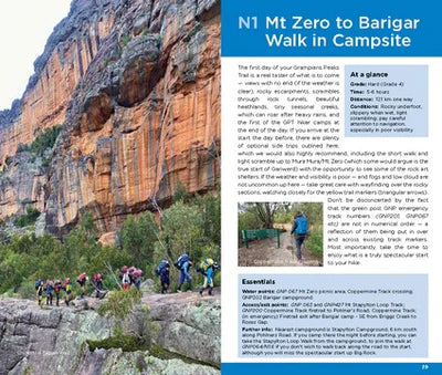
📸 150+ high-quality photographs — capturing ridgelines, camps, wildflowers and vast views
🌿 Ecology, geology & cultural context — woven into the walking narrative, not bolted on
📅 Flexible itineraries — from day walks and 2–3-day sections to the full 13-day traverse
⚠️ Logistics & safety guidance — camps, water strategy, weather exposure and seasonal considerations
This is a guide that helps you prepare properly, not just dream.
🗺️ What You’ll Walk Through
The Grampians Peaks Trail reveals Gariwerd in layers — physically demanding, visually dramatic and deeply storied:
🌄 Northern Grampians (Mount Zero to Halls Gap) — remote, rugged country with big skies and quiet ridges
🏞️ Wonderland Range — iconic knife-edge walking, exposed viewpoints and some of the most spectacular terrain in the park
⛰️ Major Mitchell Plateau & Mount William — the highest point in the Grampians, with sweeping views across western Victoria
🌿 Sheltered valleys & creek lines — moments of respite between demanding ridge days
🌄 Southern Grampians to Dunkeld — long escarpments and expansive views as the ranges taper into plains
Each day brings a distinct rhythm — steep climbs, airy traverses, sheltered descents — and the guide helps you anticipate both effort and reward.
🌿 More Than a Track: Walking on Country
What elevates this guide beyond logistics is its respect for place and story:
🌱 Vegetation transitions — heathland, woodland, forest and wildflower-rich plateaus
🦘 Wildlife awareness — kangaroos, emus, echidnas and abundant birdlife
🪨 Geological insight — how ancient sandstone shaped the knife-edge ridges and escarpments
📖 Cultural perspective — acknowledging Gariwerd as a living cultural landscape, not just a park
These layers encourage walkers to slow down mentally, even when the walking itself is demanding.
🥾 Walking the Grampians Peaks Trail — Your Way
While the full traverse is a serious undertaking, the guide supports a range of ambitions:
👣 Day walks — access iconic peaks and lookouts without committing to long distances
🏕️ Overnight & weekend hikes — link several sections into rewarding short adventures
📆 Section hikes — complete the trail in stages over multiple trips
🥾 End-to-end thru-hike — full guidance for pacing, staging, camps and recovery
Clear advice on designated hiker camps, booking systems, water availability and seasonal heat is invaluable in this exposed environment.
🧭 Who the Trail Suits
The Grampians Peaks Trail is physically demanding and often exposed, and the guide reflects that honestly:
⚖️ Moderate to challenging terrain — sustained climbs, rocky footpads and exposed ridges
🥾 Best suited to experienced bushwalkers with sound fitness and navigation skills
🌞 Heat and weather awareness essential — summer conditions require careful planning
📋 Rewarding but unforgiving — preparation is the key to enjoyment
This guide is especially valuable for walkers new to long, exposed Australian mountain trails.
📖 Book Specifications
📘 Title: The Grampians Peaks Trail
✍️ Authors: Julie Mundy & Debra Heyes
🏛️ Publisher: Woodslane Press
📆 Edition: Latest edition
📄 Format: Paperback
📐 Dimensions: approx. 220 × 130 mm
📄 Pages: richly illustrated
📸 Illustrations: 150+ full-colour photographs & detailed maps
🔢 ISBN: 9781922800091
Substantial yet packable — designed for serious planning and reliable field use.
🎯 Who This Book Is For
🥾 Experienced bushwalkers planning a major Australian trail
🌄 Hikers seeking exposed ridges, big views and physical challenge
📸 Landscape photographers chasing dramatic light and wildflowers
🚗 Victorian walkers exploring beyond day-walk territory
🧭 Anyone who values clear, honest, field-tested guidance
If you see walking as a way to test yourself while connecting deeply with Country, this guide belongs in your kit.
⭐ A Landmark Trail, Thoughtfully Guided
The Grampians Peaks Trail is not a casual walk — it’s a commitment to distance, effort and immersion. In return, it offers some of the most dramatic and rewarding walking in Australia. The Grampians Peaks Trail guide respects that challenge, equipping you with the insight and confidence to walk it well.
From the first ridgeline out of Mount Zero to the final steps down into Dunkeld, this is a journey that stays with you.
Add it to your pack and experience Gariwerd — one peak, one ridge, one unforgettable day at a time. 🥾🏔️
Product Information
Product Information
Shipping & Returns
Shipping & Returns


The Grampians Peaks Trail Woodslane
The Grampians Peaks Trail Woodslane
The Grampians Peaks Trail — Gariwerd on Foot
🥾 Rugged Peaks • Knife-Edge Ridges • Ancient Country — One of Australia’s Great Walks
Rising dramatically from the western plains of Victoria, Grampians National Park — known to its Traditional Owners as Gariwerd — is a landscape of sandstone mountains, soaring escarpments and deep cultural meaning. The Grampians Peaks Trail is its defining journey: a 164-kilometre, north–south traverse from Mount Zero to Dunkeld, typically walked over 13 days / 12 nights.
The Grampians Peaks Trail, published by Woodslane Press, is the definitive, field-ready guide to this ambitious walk. It is written for hikers who want clarity, realism and respect for Country — whether you’re planning the full end-to-end experience or selecting standout sections for shorter adventures.
🌟 Why This Guide Is a Standout
This guide earns its reputation by treating the trail as a serious expedition, while remaining approachable and practical:
🥾 Complete end-to-end coverage — every section of the Grampians Peaks Trail clearly described
📏 Realistic planning detail — distances, daily elevation gain/loss, grades and achievable time estimates
🗺️ Clear, field-ready full-colour maps — designed to be used in exposed, remote terrain
📸 150+ high-quality photographs — capturing ridgelines, camps, wildflowers and vast views
🌿 Ecology, geology & cultural context — woven into the walking narrative, not bolted on
📅 Flexible itineraries — from day walks and 2–3-day sections to the full 13-day traverse
⚠️ Logistics & safety guidance — camps, water strategy, weather exposure and seasonal considerations
This is a guide that helps you prepare properly, not just dream.
🗺️ What You’ll Walk Through
The Grampians Peaks Trail reveals Gariwerd in layers — physically demanding, visually dramatic and deeply storied:
🌄 Northern Grampians (Mount Zero to Halls Gap) — remote, rugged country with big skies and quiet ridges
🏞️ Wonderland Range — iconic knife-edge walking, exposed viewpoints and some of the most spectacular terrain in the park
⛰️ Major Mitchell Plateau & Mount William — the highest point in the Grampians, with sweeping views across western Victoria
🌿 Sheltered valleys & creek lines — moments of respite between demanding ridge days
🌄 Southern Grampians to Dunkeld — long escarpments and expansive views as the ranges taper into plains
Each day brings a distinct rhythm — steep climbs, airy traverses, sheltered descents — and the guide helps you anticipate both effort and reward.
🌿 More Than a Track: Walking on Country
What elevates this guide beyond logistics is its respect for place and story:
🌱 Vegetation transitions — heathland, woodland, forest and wildflower-rich plateaus
🦘 Wildlife awareness — kangaroos, emus, echidnas and abundant birdlife
🪨 Geological insight — how ancient sandstone shaped the knife-edge ridges and escarpments
📖 Cultural perspective — acknowledging Gariwerd as a living cultural landscape, not just a park
These layers encourage walkers to slow down mentally, even when the walking itself is demanding.
🥾 Walking the Grampians Peaks Trail — Your Way
While the full traverse is a serious undertaking, the guide supports a range of ambitions:
👣 Day walks — access iconic peaks and lookouts without committing to long distances
🏕️ Overnight & weekend hikes — link several sections into rewarding short adventures
📆 Section hikes — complete the trail in stages over multiple trips
🥾 End-to-end thru-hike — full guidance for pacing, staging, camps and recovery
Clear advice on designated hiker camps, booking systems, water availability and seasonal heat is invaluable in this exposed environment.
🧭 Who the Trail Suits
The Grampians Peaks Trail is physically demanding and often exposed, and the guide reflects that honestly:
⚖️ Moderate to challenging terrain — sustained climbs, rocky footpads and exposed ridges
🥾 Best suited to experienced bushwalkers with sound fitness and navigation skills
🌞 Heat and weather awareness essential — summer conditions require careful planning
📋 Rewarding but unforgiving — preparation is the key to enjoyment
This guide is especially valuable for walkers new to long, exposed Australian mountain trails.
📖 Book Specifications
📘 Title: The Grampians Peaks Trail
✍️ Authors: Julie Mundy & Debra Heyes
🏛️ Publisher: Woodslane Press
📆 Edition: Latest edition
📄 Format: Paperback
📐 Dimensions: approx. 220 × 130 mm
📄 Pages: richly illustrated
📸 Illustrations: 150+ full-colour photographs & detailed maps
🔢 ISBN: 9781922800091
Substantial yet packable — designed for serious planning and reliable field use.
🎯 Who This Book Is For
🥾 Experienced bushwalkers planning a major Australian trail
🌄 Hikers seeking exposed ridges, big views and physical challenge
📸 Landscape photographers chasing dramatic light and wildflowers
🚗 Victorian walkers exploring beyond day-walk territory
🧭 Anyone who values clear, honest, field-tested guidance
If you see walking as a way to test yourself while connecting deeply with Country, this guide belongs in your kit.
⭐ A Landmark Trail, Thoughtfully Guided
The Grampians Peaks Trail is not a casual walk — it’s a commitment to distance, effort and immersion. In return, it offers some of the most dramatic and rewarding walking in Australia. The Grampians Peaks Trail guide respects that challenge, equipping you with the insight and confidence to walk it well.
From the first ridgeline out of Mount Zero to the final steps down into Dunkeld, this is a journey that stays with you.
Add it to your pack and experience Gariwerd — one peak, one ridge, one unforgettable day at a time. 🥾🏔️
Product Information
Product Information
Shipping & Returns
Shipping & Returns
Description
The Grampians Peaks Trail — Gariwerd on Foot
🥾 Rugged Peaks • Knife-Edge Ridges • Ancient Country — One of Australia’s Great Walks
Rising dramatically from the western plains of Victoria, Grampians National Park — known to its Traditional Owners as Gariwerd — is a landscape of sandstone mountains, soaring escarpments and deep cultural meaning. The Grampians Peaks Trail is its defining journey: a 164-kilometre, north–south traverse from Mount Zero to Dunkeld, typically walked over 13 days / 12 nights.
The Grampians Peaks Trail, published by Woodslane Press, is the definitive, field-ready guide to this ambitious walk. It is written for hikers who want clarity, realism and respect for Country — whether you’re planning the full end-to-end experience or selecting standout sections for shorter adventures.
🌟 Why This Guide Is a Standout
This guide earns its reputation by treating the trail as a serious expedition, while remaining approachable and practical:
🥾 Complete end-to-end coverage — every section of the Grampians Peaks Trail clearly described
📏 Realistic planning detail — distances, daily elevation gain/loss, grades and achievable time estimates
🗺️ Clear, field-ready full-colour maps — designed to be used in exposed, remote terrain
📸 150+ high-quality photographs — capturing ridgelines, camps, wildflowers and vast views
🌿 Ecology, geology & cultural context — woven into the walking narrative, not bolted on
📅 Flexible itineraries — from day walks and 2–3-day sections to the full 13-day traverse
⚠️ Logistics & safety guidance — camps, water strategy, weather exposure and seasonal considerations
This is a guide that helps you prepare properly, not just dream.
🗺️ What You’ll Walk Through
The Grampians Peaks Trail reveals Gariwerd in layers — physically demanding, visually dramatic and deeply storied:
🌄 Northern Grampians (Mount Zero to Halls Gap) — remote, rugged country with big skies and quiet ridges
🏞️ Wonderland Range — iconic knife-edge walking, exposed viewpoints and some of the most spectacular terrain in the park
⛰️ Major Mitchell Plateau & Mount William — the highest point in the Grampians, with sweeping views across western Victoria
🌿 Sheltered valleys & creek lines — moments of respite between demanding ridge days
🌄 Southern Grampians to Dunkeld — long escarpments and expansive views as the ranges taper into plains
Each day brings a distinct rhythm — steep climbs, airy traverses, sheltered descents — and the guide helps you anticipate both effort and reward.
🌿 More Than a Track: Walking on Country
What elevates this guide beyond logistics is its respect for place and story:
🌱 Vegetation transitions — heathland, woodland, forest and wildflower-rich plateaus
🦘 Wildlife awareness — kangaroos, emus, echidnas and abundant birdlife
🪨 Geological insight — how ancient sandstone shaped the knife-edge ridges and escarpments
📖 Cultural perspective — acknowledging Gariwerd as a living cultural landscape, not just a park
These layers encourage walkers to slow down mentally, even when the walking itself is demanding.
🥾 Walking the Grampians Peaks Trail — Your Way
While the full traverse is a serious undertaking, the guide supports a range of ambitions:
👣 Day walks — access iconic peaks and lookouts without committing to long distances
🏕️ Overnight & weekend hikes — link several sections into rewarding short adventures
📆 Section hikes — complete the trail in stages over multiple trips
🥾 End-to-end thru-hike — full guidance for pacing, staging, camps and recovery
Clear advice on designated hiker camps, booking systems, water availability and seasonal heat is invaluable in this exposed environment.
🧭 Who the Trail Suits
The Grampians Peaks Trail is physically demanding and often exposed, and the guide reflects that honestly:
⚖️ Moderate to challenging terrain — sustained climbs, rocky footpads and exposed ridges
🥾 Best suited to experienced bushwalkers with sound fitness and navigation skills
🌞 Heat and weather awareness essential — summer conditions require careful planning
📋 Rewarding but unforgiving — preparation is the key to enjoyment
This guide is especially valuable for walkers new to long, exposed Australian mountain trails.
📖 Book Specifications
📘 Title: The Grampians Peaks Trail
✍️ Authors: Julie Mundy & Debra Heyes
🏛️ Publisher: Woodslane Press
📆 Edition: Latest edition
📄 Format: Paperback
📐 Dimensions: approx. 220 × 130 mm
📄 Pages: richly illustrated
📸 Illustrations: 150+ full-colour photographs & detailed maps
🔢 ISBN: 9781922800091
Substantial yet packable — designed for serious planning and reliable field use.
🎯 Who This Book Is For
🥾 Experienced bushwalkers planning a major Australian trail
🌄 Hikers seeking exposed ridges, big views and physical challenge
📸 Landscape photographers chasing dramatic light and wildflowers
🚗 Victorian walkers exploring beyond day-walk territory
🧭 Anyone who values clear, honest, field-tested guidance
If you see walking as a way to test yourself while connecting deeply with Country, this guide belongs in your kit.
⭐ A Landmark Trail, Thoughtfully Guided
The Grampians Peaks Trail is not a casual walk — it’s a commitment to distance, effort and immersion. In return, it offers some of the most dramatic and rewarding walking in Australia. The Grampians Peaks Trail guide respects that challenge, equipping you with the insight and confidence to walk it well.
From the first ridgeline out of Mount Zero to the final steps down into Dunkeld, this is a journey that stays with you.
Add it to your pack and experience Gariwerd — one peak, one ridge, one unforgettable day at a time. 🥾🏔️