The West Country & South Wales AA Road Map 1
Scale: 1:200,000 | Folded Paper Map | 2024 Edition
Explore Cornwall, Devon, Somerset, Bristol, South Wales & More
🌄 Discover the Charm of Britain’s Southwest and Celtic Coast
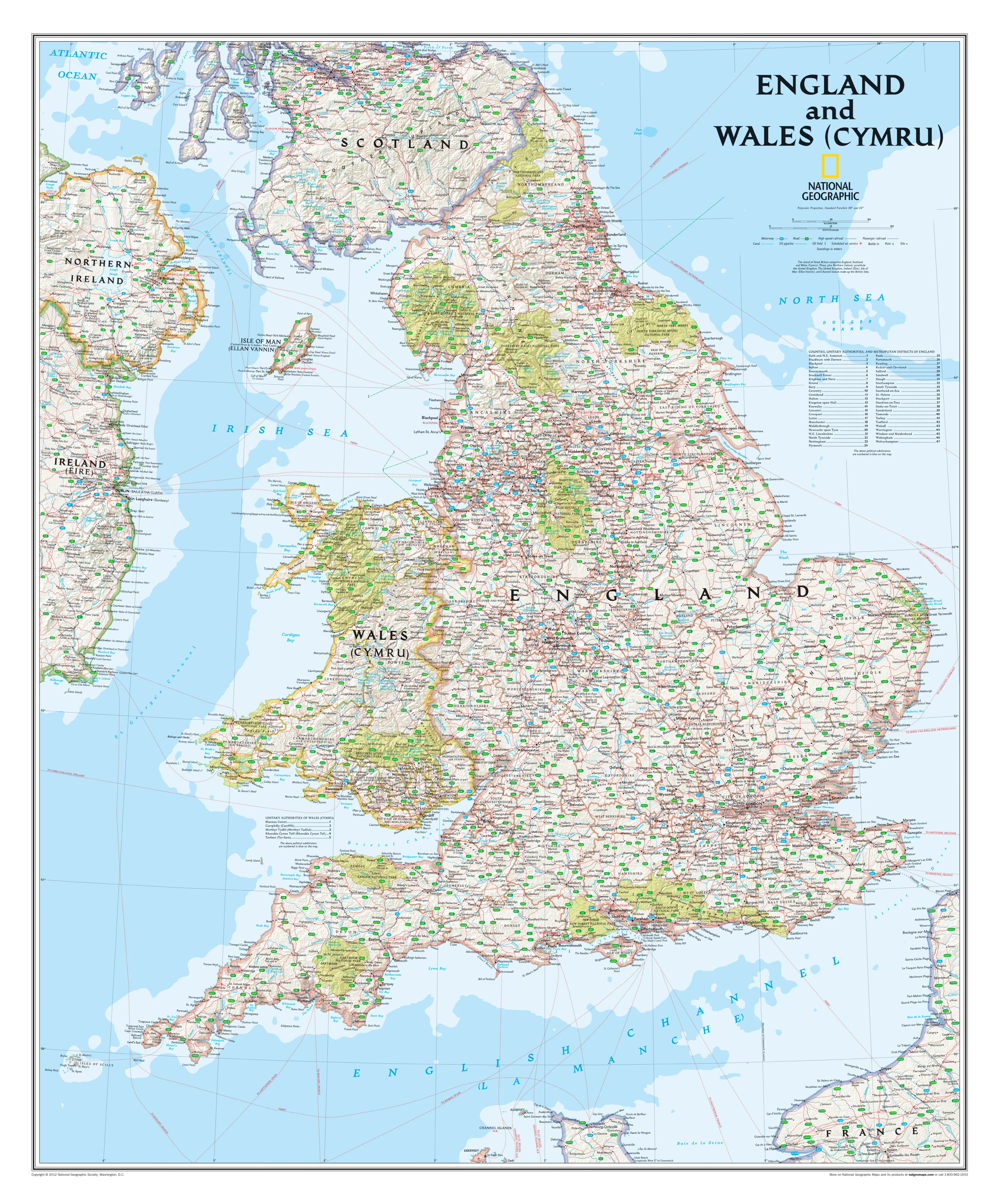
From the wave-battered cliffs of Cornwall to the verdant hills of South Wales, the West Country & South Wales region is a treasure trove of dramatic coastlines, historic towns, national parks, and vibrant cultural heritage. Whether you’re embarking on a coastal caravan tour, winding through moorland villages, or tracing the industrial roots of Welsh cities, this AA Road Map 1 is your indispensable guide to navigating it all with confidence and clarity.
Created by the trusted cartographers at the Automobile Association (AA) — a name synonymous with precision mapping in the UK — this beautifully designed, large-format road map offers the perfect balance between detail and usability. It’s more than just a map; it’s a travel tool built for discovery.
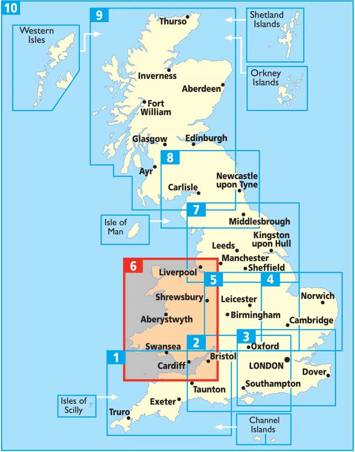
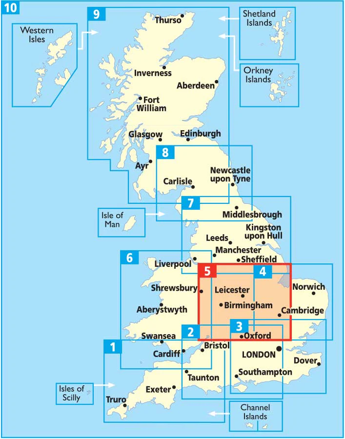
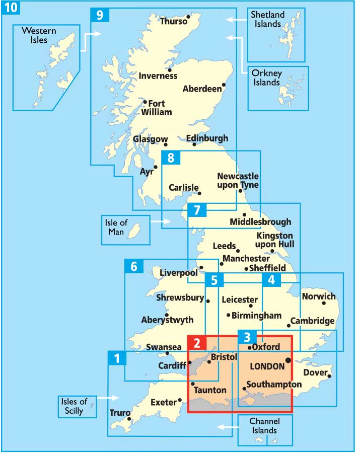
🗺️ Regional Coverage
This map spans a broad and rich section of the UK, including:
-
Cornwall – from St Ives to Land’s End and beyond
-
Devon – Dartmoor, Exmoor, Exeter, Torbay and the Jurassic Coast
-
Somerset – including Bath, Glastonbury, Wells, and the Quantock Hills
-
Bristol & Gloucestershire – urban and historic heartlands
-
South Wales – including Cardiff, Swansea, Newport, and the Gower Peninsula
With a scale of 1:200,000 (3 miles to 1 inch), the map gives an excellent overview of the road network while still showing plenty of local detail — perfect for planning longer drives or zooming in on hidden gems.
🧭 Features at a Glance
🛣️ Fully Updated Road Network
All motorways, dual carriageways, A-roads and local routes are clearly marked. Road numbers, toll routes, and service areas are included, along with distances for easy trip planning.
🚦 Speed Camera Alerts
Speed camera locations and the posted limits are shown — a thoughtful inclusion for safety-conscious drivers and those unfamiliar with local enforcement.
🏞️ National Parks & Natural Highlights
The map highlights important landscapes such as:
-
Dartmoor & Exmoor National Parks
-
The Gower Peninsula
-
Brecon Beacons
-
Mendip Hills
-
The Forest of Dean
🏕️ Touring and Visitor Essentials
Symbols indicate:
-
Caravan parks & campsites
-
National Trust and English Heritage sites
-
Welsh & Scottish Heritage sites
-
Tourist attractions & places of interest
🗺️ Detailed City Insets
Includes 15 inset maps of key cities and towns, giving you a zoomed-in view for urban navigation:
-
Bristol
-
Bath
-
Cardiff
-
Newport
-
Swansea
-
Poole
-
Exeter
-
Plymouth
-
Torquay
-
Paignton
-
Brixham
-
Newquay
-
Weston-super-Mare
-
Taunton
-
Bournemouth
Each inset features detailed road layouts, parking areas, and key urban landmarks — great for navigating unfamiliar streets or planning city stops.
📍 Index & Navigation Aids
A full place name index allows for fast look-ups, while clear road numbering and sign-post-style labels make it easy to plot routes with minimal fuss.
📏 Specifications
| Feature | Description |
|---|---|
| Map Title | The West Country & South Wales – AA Road Map 1 |
| Scale | 1:200,000 (3 miles = 1 inch) |
| Format | Folded Paper Map |
| Sheet Size (Unfolded) | 1200 mm x 980 mm |
| Edition | 2024 |
| Publisher | Automobile Association (AA) |
| Legend Language | English |
| Printed in | United Kingdom |
🚗 Who Is This Map For?
-
Road Trippers & Holidaymakers: Ideal for those exploring Devon, Cornwall, and Wales by car, camper, or motorcycle.
-
Outdoor Enthusiasts: Find walking trails, national parks, and natural beauty with ease.
-
Families on Vacation: Plan visits to castles, coastlines, attractions, and museums.
-
Caravanners & Campers: Pinpoint campsites and plan fuel stops along scenic routes.
-
Educators & Map Collectors: A practical, informative addition to any classroom or collection.
🛒 Why Buy This Map?
Digital navigation is handy — until your mobile signal disappears halfway through Dartmoor. Having a paper map gives you control, context, and the ability to see the whole journey at once. With its crystal-clear layout and thoughtful features, the West Country & South Wales AA Road Map is a must-have for anyone travelling the region.
Plan better. Explore deeper. Drive smarter.
Add this map to your travel toolkit and take the scenic route with confidence.
Product Information
Product Information
Shipping & Returns
Shipping & Returns


The West Country & South Wales AA Road Map 1
The West Country & South Wales AA Road Map 1
Scale: 1:200,000 | Folded Paper Map | 2024 Edition
Explore Cornwall, Devon, Somerset, Bristol, South Wales & More
🌄 Discover the Charm of Britain’s Southwest and Celtic Coast
From the wave-battered cliffs of Cornwall to the verdant hills of South Wales, the West Country & South Wales region is a treasure trove of dramatic coastlines, historic towns, national parks, and vibrant cultural heritage. Whether you’re embarking on a coastal caravan tour, winding through moorland villages, or tracing the industrial roots of Welsh cities, this AA Road Map 1 is your indispensable guide to navigating it all with confidence and clarity.
Created by the trusted cartographers at the Automobile Association (AA) — a name synonymous with precision mapping in the UK — this beautifully designed, large-format road map offers the perfect balance between detail and usability. It’s more than just a map; it’s a travel tool built for discovery.
🗺️ Regional Coverage
This map spans a broad and rich section of the UK, including:
-
Cornwall – from St Ives to Land’s End and beyond
-
Devon – Dartmoor, Exmoor, Exeter, Torbay and the Jurassic Coast
-
Somerset – including Bath, Glastonbury, Wells, and the Quantock Hills
-
Bristol & Gloucestershire – urban and historic heartlands
-
South Wales – including Cardiff, Swansea, Newport, and the Gower Peninsula
With a scale of 1:200,000 (3 miles to 1 inch), the map gives an excellent overview of the road network while still showing plenty of local detail — perfect for planning longer drives or zooming in on hidden gems.
🧭 Features at a Glance
🛣️ Fully Updated Road Network
All motorways, dual carriageways, A-roads and local routes are clearly marked. Road numbers, toll routes, and service areas are included, along with distances for easy trip planning.
🚦 Speed Camera Alerts
Speed camera locations and the posted limits are shown — a thoughtful inclusion for safety-conscious drivers and those unfamiliar with local enforcement.
🏞️ National Parks & Natural Highlights
The map highlights important landscapes such as:
-
Dartmoor & Exmoor National Parks
-
The Gower Peninsula
-
Brecon Beacons
-
Mendip Hills
-
The Forest of Dean
🏕️ Touring and Visitor Essentials
Symbols indicate:
-
Caravan parks & campsites
-
National Trust and English Heritage sites
-
Welsh & Scottish Heritage sites
-
Tourist attractions & places of interest
🗺️ Detailed City Insets
Includes 15 inset maps of key cities and towns, giving you a zoomed-in view for urban navigation:
-
Bristol
-
Bath
-
Cardiff
-
Newport
-
Swansea
-
Poole
-
Exeter
-
Plymouth
-
Torquay
-
Paignton
-
Brixham
-
Newquay
-
Weston-super-Mare
-
Taunton
-
Bournemouth
Each inset features detailed road layouts, parking areas, and key urban landmarks — great for navigating unfamiliar streets or planning city stops.
📍 Index & Navigation Aids
A full place name index allows for fast look-ups, while clear road numbering and sign-post-style labels make it easy to plot routes with minimal fuss.
📏 Specifications
| Feature | Description |
|---|---|
| Map Title | The West Country & South Wales – AA Road Map 1 |
| Scale | 1:200,000 (3 miles = 1 inch) |
| Format | Folded Paper Map |
| Sheet Size (Unfolded) | 1200 mm x 980 mm |
| Edition | 2024 |
| Publisher | Automobile Association (AA) |
| Legend Language | English |
| Printed in | United Kingdom |
🚗 Who Is This Map For?
-
Road Trippers & Holidaymakers: Ideal for those exploring Devon, Cornwall, and Wales by car, camper, or motorcycle.
-
Outdoor Enthusiasts: Find walking trails, national parks, and natural beauty with ease.
-
Families on Vacation: Plan visits to castles, coastlines, attractions, and museums.
-
Caravanners & Campers: Pinpoint campsites and plan fuel stops along scenic routes.
-
Educators & Map Collectors: A practical, informative addition to any classroom or collection.
🛒 Why Buy This Map?
Digital navigation is handy — until your mobile signal disappears halfway through Dartmoor. Having a paper map gives you control, context, and the ability to see the whole journey at once. With its crystal-clear layout and thoughtful features, the West Country & South Wales AA Road Map is a must-have for anyone travelling the region.
Plan better. Explore deeper. Drive smarter.
Add this map to your travel toolkit and take the scenic route with confidence.
Original: $19.95
-70%$19.95
$5.98Product Information
Product Information
Shipping & Returns
Shipping & Returns
Description
Scale: 1:200,000 | Folded Paper Map | 2024 Edition
Explore Cornwall, Devon, Somerset, Bristol, South Wales & More
🌄 Discover the Charm of Britain’s Southwest and Celtic Coast
From the wave-battered cliffs of Cornwall to the verdant hills of South Wales, the West Country & South Wales region is a treasure trove of dramatic coastlines, historic towns, national parks, and vibrant cultural heritage. Whether you’re embarking on a coastal caravan tour, winding through moorland villages, or tracing the industrial roots of Welsh cities, this AA Road Map 1 is your indispensable guide to navigating it all with confidence and clarity.
Created by the trusted cartographers at the Automobile Association (AA) — a name synonymous with precision mapping in the UK — this beautifully designed, large-format road map offers the perfect balance between detail and usability. It’s more than just a map; it’s a travel tool built for discovery.
🗺️ Regional Coverage
This map spans a broad and rich section of the UK, including:
-
Cornwall – from St Ives to Land’s End and beyond
-
Devon – Dartmoor, Exmoor, Exeter, Torbay and the Jurassic Coast
-
Somerset – including Bath, Glastonbury, Wells, and the Quantock Hills
-
Bristol & Gloucestershire – urban and historic heartlands
-
South Wales – including Cardiff, Swansea, Newport, and the Gower Peninsula
With a scale of 1:200,000 (3 miles to 1 inch), the map gives an excellent overview of the road network while still showing plenty of local detail — perfect for planning longer drives or zooming in on hidden gems.
🧭 Features at a Glance
🛣️ Fully Updated Road Network
All motorways, dual carriageways, A-roads and local routes are clearly marked. Road numbers, toll routes, and service areas are included, along with distances for easy trip planning.
🚦 Speed Camera Alerts
Speed camera locations and the posted limits are shown — a thoughtful inclusion for safety-conscious drivers and those unfamiliar with local enforcement.
🏞️ National Parks & Natural Highlights
The map highlights important landscapes such as:
-
Dartmoor & Exmoor National Parks
-
The Gower Peninsula
-
Brecon Beacons
-
Mendip Hills
-
The Forest of Dean
🏕️ Touring and Visitor Essentials
Symbols indicate:
-
Caravan parks & campsites
-
National Trust and English Heritage sites
-
Welsh & Scottish Heritage sites
-
Tourist attractions & places of interest
🗺️ Detailed City Insets
Includes 15 inset maps of key cities and towns, giving you a zoomed-in view for urban navigation:
-
Bristol
-
Bath
-
Cardiff
-
Newport
-
Swansea
-
Poole
-
Exeter
-
Plymouth
-
Torquay
-
Paignton
-
Brixham
-
Newquay
-
Weston-super-Mare
-
Taunton
-
Bournemouth
Each inset features detailed road layouts, parking areas, and key urban landmarks — great for navigating unfamiliar streets or planning city stops.
📍 Index & Navigation Aids
A full place name index allows for fast look-ups, while clear road numbering and sign-post-style labels make it easy to plot routes with minimal fuss.
📏 Specifications
| Feature | Description |
|---|---|
| Map Title | The West Country & South Wales – AA Road Map 1 |
| Scale | 1:200,000 (3 miles = 1 inch) |
| Format | Folded Paper Map |
| Sheet Size (Unfolded) | 1200 mm x 980 mm |
| Edition | 2024 |
| Publisher | Automobile Association (AA) |
| Legend Language | English |
| Printed in | United Kingdom |
🚗 Who Is This Map For?
-
Road Trippers & Holidaymakers: Ideal for those exploring Devon, Cornwall, and Wales by car, camper, or motorcycle.
-
Outdoor Enthusiasts: Find walking trails, national parks, and natural beauty with ease.
-
Families on Vacation: Plan visits to castles, coastlines, attractions, and museums.
-
Caravanners & Campers: Pinpoint campsites and plan fuel stops along scenic routes.
-
Educators & Map Collectors: A practical, informative addition to any classroom or collection.
🛒 Why Buy This Map?
Digital navigation is handy — until your mobile signal disappears halfway through Dartmoor. Having a paper map gives you control, context, and the ability to see the whole journey at once. With its crystal-clear layout and thoughtful features, the West Country & South Wales AA Road Map is a must-have for anyone travelling the region.
Plan better. Explore deeper. Drive smarter.
Add this map to your travel toolkit and take the scenic route with confidence.