Crete, Mykonos & Santorini / Eastern Mediterranean ITMB Map
Crete, Mykonos & Santorini / Eastern Mediterranean — ITMB Map
Waterproof • Folded Travel Map • Double-Sided • Printed in Full Colour
🇬🇷 Explore the Aegean’s Most Iconic Isles
From the windswept white villages of Santorini to the rugged ridges of Crete, this ITMB double-sided map captures the heart of Greece’s southern archipelagos in vivid cartographic detail. Designed for travellers, sailors, and history enthusiasts, it offers both local-scale coverage of the key islands and broader regional context of the Eastern Mediterranean.
Whether you’re navigating Crete’s ancient Minoan sites, planning a ferry journey across the Cyclades, or tracing the classical geography of the Aegean Sea, this map combines precision with wanderlust.
🗺 Map Coverage
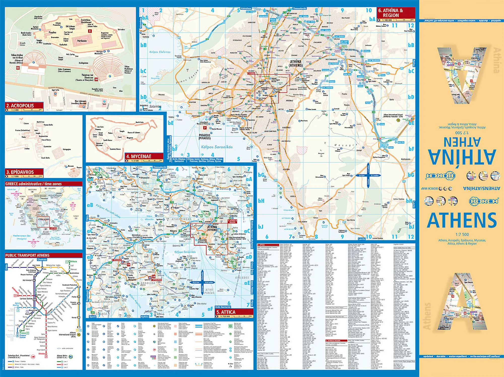
Side 1 – Crete, Mykonos & Santorini
-
Crete in exceptional detail — mountains, roads, towns, ports, archaeological sites, beaches, and coastal villages.
-
Mykonos & Rinia — detailed insets showing ferry routes, harbours, and main roads.
-
Santorini (Thira) — with Thirasia and Nea Kameni volcano islets shown in high relief.
-
Inset Map – Greece and island positioning for reference within the Aegean Sea.
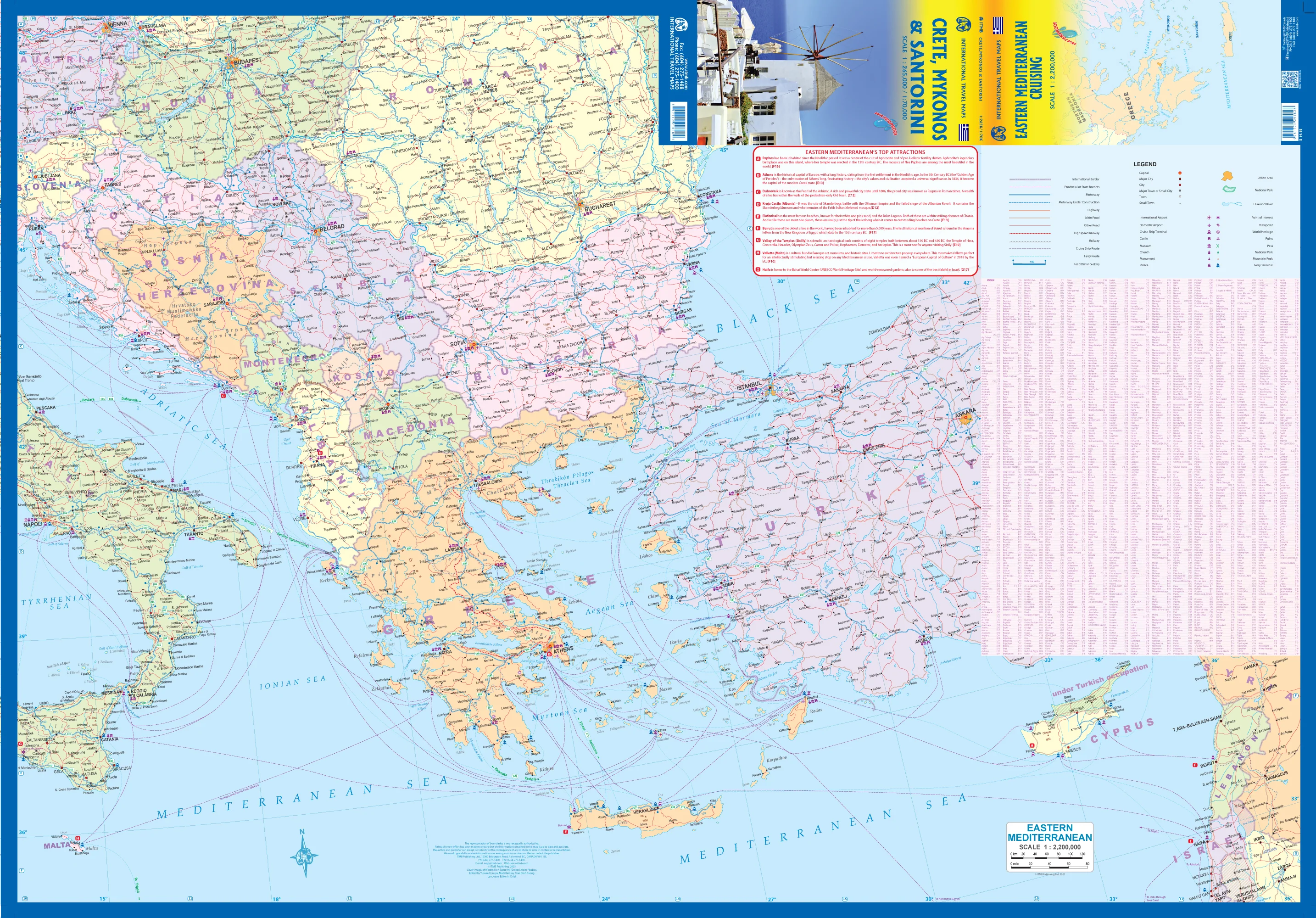
Side 2 – Eastern Mediterranean Overview
-
Broad-scale map of Greece and its eastern neighbours, connecting the Balkan Peninsula with Turkey, Cyprus, and the Levant.
-
Labels and boundaries across the Adriatic, Ionian, Myrtoan, and Aegean Seas.
-
A clear overview of the region’s maritime geography and political context — ideal for educational, historical, and cruising reference.
🧭 Key Features
-
Scale: Regional overview + local island detail for Crete & Cyclades.
-
Contour relief shading – visualises mountain and coastal terrain.
-
Touristic points – towns, ancient ruins, ports, airports, beaches, and ferry lines.
-
Road networks – highways, secondary roads, rural and coastal routes.
-
Ferry connections – between main island hubs.
-
Inset locator maps – place the islands in relation to the wider Mediterranean basin.
🧾 Product Details
| Feature | Detail |
|---|---|
| Title | Crete, Mykonos & Santorini / Eastern Mediterranean ITMB Map |
| Publisher | ITMB (International Travel Maps, Canada) |
| Scale | Variable (regional overview + detailed island mapping) |
| Map Type | Double-sided folded travel map |
| Coverage | Crete, Mykonos, Santorini, Rinia, Thirasia, Nea Kameni, Eastern Mediterranean overview |
| Sheet Size | 1000 mm × 690 mm |
| Finish | Folded paper (optional laminated upgrade available) |
| Material Options | 120 gsm matte coated paper (fade-resistant pigment inks) • Laminated (2 × 80 μm gloss encapsulated, waterproof, wipe-clean) |
| Inks | HP pigment-based, fade-resistant |
| Origin | Designed in Canada • Printed in Australia |
🌍 Why Travellers Love This Map
-
Two maps in one – local navigation and regional context together.
-
Essential for island-hopping – ferry routes and geography clearly shown.
-
Ideal for students & historians – visualises ancient and modern connections across the Aegean.
-
Display-worthy – vivid topography and coastal contours suitable for framing.
-
Field-durable – optional lamination makes it tear-resistant and travel-ready.
✈️ Perfect For
-
Travellers exploring Crete, Santorini, and the Cyclades
-
Cruise and ferry passengers navigating the Aegean
-
Teachers and students of classical geography
-
Yacht skippers and Mediterranean explorers
-
Map collectors and Hellenic history enthusiasts
🏛 Explore the Ancient & the Eternal
From the palaces of Knossos to the caldera cliffs of Oia, let this ITMB map be your guide through the myths, mountains, and seas that shaped Western civilisation.
Product Information
Product Information
Shipping & Returns
Shipping & Returns


Crete, Mykonos & Santorini / Eastern Mediterranean ITMB Map
Crete, Mykonos & Santorini / Eastern Mediterranean ITMB Map
Crete, Mykonos & Santorini / Eastern Mediterranean — ITMB Map
Waterproof • Folded Travel Map • Double-Sided • Printed in Full Colour
🇬🇷 Explore the Aegean’s Most Iconic Isles
From the windswept white villages of Santorini to the rugged ridges of Crete, this ITMB double-sided map captures the heart of Greece’s southern archipelagos in vivid cartographic detail. Designed for travellers, sailors, and history enthusiasts, it offers both local-scale coverage of the key islands and broader regional context of the Eastern Mediterranean.
Whether you’re navigating Crete’s ancient Minoan sites, planning a ferry journey across the Cyclades, or tracing the classical geography of the Aegean Sea, this map combines precision with wanderlust.
🗺 Map Coverage
Side 1 – Crete, Mykonos & Santorini
-
Crete in exceptional detail — mountains, roads, towns, ports, archaeological sites, beaches, and coastal villages.
-
Mykonos & Rinia — detailed insets showing ferry routes, harbours, and main roads.
-
Santorini (Thira) — with Thirasia and Nea Kameni volcano islets shown in high relief.
-
Inset Map – Greece and island positioning for reference within the Aegean Sea.
Side 2 – Eastern Mediterranean Overview
-
Broad-scale map of Greece and its eastern neighbours, connecting the Balkan Peninsula with Turkey, Cyprus, and the Levant.
-
Labels and boundaries across the Adriatic, Ionian, Myrtoan, and Aegean Seas.
-
A clear overview of the region’s maritime geography and political context — ideal for educational, historical, and cruising reference.
🧭 Key Features
-
Scale: Regional overview + local island detail for Crete & Cyclades.
-
Contour relief shading – visualises mountain and coastal terrain.
-
Touristic points – towns, ancient ruins, ports, airports, beaches, and ferry lines.
-
Road networks – highways, secondary roads, rural and coastal routes.
-
Ferry connections – between main island hubs.
-
Inset locator maps – place the islands in relation to the wider Mediterranean basin.
🧾 Product Details
| Feature | Detail |
|---|---|
| Title | Crete, Mykonos & Santorini / Eastern Mediterranean ITMB Map |
| Publisher | ITMB (International Travel Maps, Canada) |
| Scale | Variable (regional overview + detailed island mapping) |
| Map Type | Double-sided folded travel map |
| Coverage | Crete, Mykonos, Santorini, Rinia, Thirasia, Nea Kameni, Eastern Mediterranean overview |
| Sheet Size | 1000 mm × 690 mm |
| Finish | Folded paper (optional laminated upgrade available) |
| Material Options | 120 gsm matte coated paper (fade-resistant pigment inks) • Laminated (2 × 80 μm gloss encapsulated, waterproof, wipe-clean) |
| Inks | HP pigment-based, fade-resistant |
| Origin | Designed in Canada • Printed in Australia |
🌍 Why Travellers Love This Map
-
Two maps in one – local navigation and regional context together.
-
Essential for island-hopping – ferry routes and geography clearly shown.
-
Ideal for students & historians – visualises ancient and modern connections across the Aegean.
-
Display-worthy – vivid topography and coastal contours suitable for framing.
-
Field-durable – optional lamination makes it tear-resistant and travel-ready.
✈️ Perfect For
-
Travellers exploring Crete, Santorini, and the Cyclades
-
Cruise and ferry passengers navigating the Aegean
-
Teachers and students of classical geography
-
Yacht skippers and Mediterranean explorers
-
Map collectors and Hellenic history enthusiasts
🏛 Explore the Ancient & the Eternal
From the palaces of Knossos to the caldera cliffs of Oia, let this ITMB map be your guide through the myths, mountains, and seas that shaped Western civilisation.
Original: $24.95
-70%$24.95
$7.48Product Information
Product Information
Shipping & Returns
Shipping & Returns
Description
Crete, Mykonos & Santorini / Eastern Mediterranean — ITMB Map
Waterproof • Folded Travel Map • Double-Sided • Printed in Full Colour
🇬🇷 Explore the Aegean’s Most Iconic Isles
From the windswept white villages of Santorini to the rugged ridges of Crete, this ITMB double-sided map captures the heart of Greece’s southern archipelagos in vivid cartographic detail. Designed for travellers, sailors, and history enthusiasts, it offers both local-scale coverage of the key islands and broader regional context of the Eastern Mediterranean.
Whether you’re navigating Crete’s ancient Minoan sites, planning a ferry journey across the Cyclades, or tracing the classical geography of the Aegean Sea, this map combines precision with wanderlust.
🗺 Map Coverage
Side 1 – Crete, Mykonos & Santorini
-
Crete in exceptional detail — mountains, roads, towns, ports, archaeological sites, beaches, and coastal villages.
-
Mykonos & Rinia — detailed insets showing ferry routes, harbours, and main roads.
-
Santorini (Thira) — with Thirasia and Nea Kameni volcano islets shown in high relief.
-
Inset Map – Greece and island positioning for reference within the Aegean Sea.
Side 2 – Eastern Mediterranean Overview
-
Broad-scale map of Greece and its eastern neighbours, connecting the Balkan Peninsula with Turkey, Cyprus, and the Levant.
-
Labels and boundaries across the Adriatic, Ionian, Myrtoan, and Aegean Seas.
-
A clear overview of the region’s maritime geography and political context — ideal for educational, historical, and cruising reference.
🧭 Key Features
-
Scale: Regional overview + local island detail for Crete & Cyclades.
-
Contour relief shading – visualises mountain and coastal terrain.
-
Touristic points – towns, ancient ruins, ports, airports, beaches, and ferry lines.
-
Road networks – highways, secondary roads, rural and coastal routes.
-
Ferry connections – between main island hubs.
-
Inset locator maps – place the islands in relation to the wider Mediterranean basin.
🧾 Product Details
| Feature | Detail |
|---|---|
| Title | Crete, Mykonos & Santorini / Eastern Mediterranean ITMB Map |
| Publisher | ITMB (International Travel Maps, Canada) |
| Scale | Variable (regional overview + detailed island mapping) |
| Map Type | Double-sided folded travel map |
| Coverage | Crete, Mykonos, Santorini, Rinia, Thirasia, Nea Kameni, Eastern Mediterranean overview |
| Sheet Size | 1000 mm × 690 mm |
| Finish | Folded paper (optional laminated upgrade available) |
| Material Options | 120 gsm matte coated paper (fade-resistant pigment inks) • Laminated (2 × 80 μm gloss encapsulated, waterproof, wipe-clean) |
| Inks | HP pigment-based, fade-resistant |
| Origin | Designed in Canada • Printed in Australia |
🌍 Why Travellers Love This Map
-
Two maps in one – local navigation and regional context together.
-
Essential for island-hopping – ferry routes and geography clearly shown.
-
Ideal for students & historians – visualises ancient and modern connections across the Aegean.
-
Display-worthy – vivid topography and coastal contours suitable for framing.
-
Field-durable – optional lamination makes it tear-resistant and travel-ready.
✈️ Perfect For
-
Travellers exploring Crete, Santorini, and the Cyclades
-
Cruise and ferry passengers navigating the Aegean
-
Teachers and students of classical geography
-
Yacht skippers and Mediterranean explorers
-
Map collectors and Hellenic history enthusiasts
🏛 Explore the Ancient & the Eternal
From the palaces of Knossos to the caldera cliffs of Oia, let this ITMB map be your guide through the myths, mountains, and seas that shaped Western civilisation.