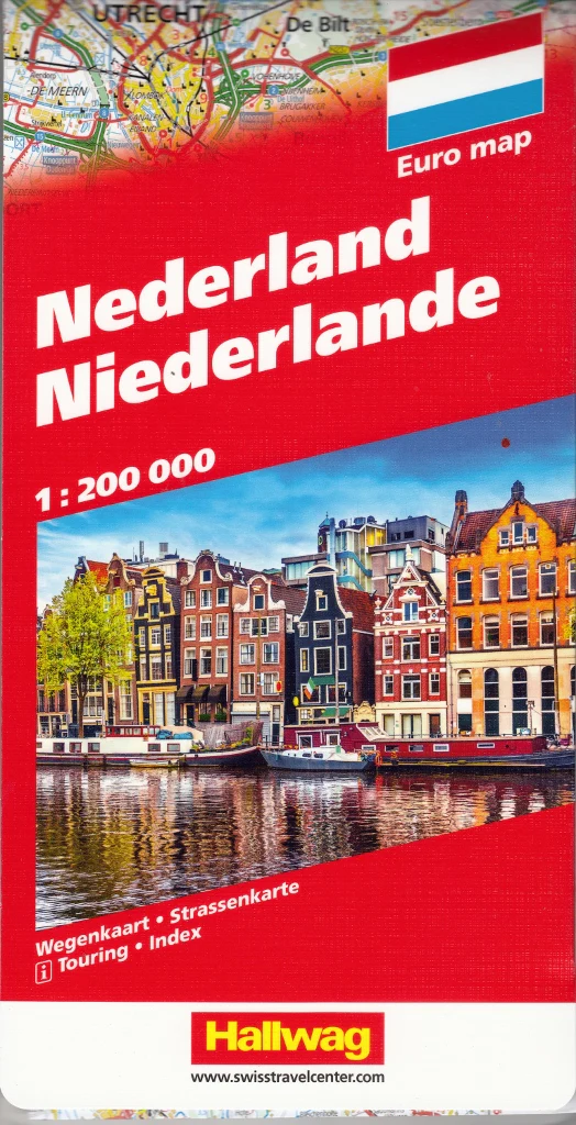
Netherlands Michelin Map 715
National Road Map | Clear, Accurate & Up-to-Date
Scale 1:400,000 | Size: 1200 x 1000 mm
Navigate the Netherlands with confidence using Michelin Map 715—a meticulously designed national road map produced by one of the most trusted names in European cartography. Whether you’re exploring the tulip fields of Holland, the canals of Amsterdam, or the dykes of Friesland, this map offers exceptional clarity and comprehensive detail for every stage of your journey.
🛣️ Michelin Mapping You Can Trust
Michelin’s signature mapping style is clear, intuitive, and highly legible. With this map, you’ll have a full view of the Netherlands' road network at a practical scale of 1:400,000—ideal for both day trips and long-distance touring.
Place names appear in the local language, as shown on road signs throughout the Netherlands, ensuring seamless navigation while travelling. A multilingual legend is included (English, French, Dutch, German, Spanish, and Italian), making it accessible for international users.
🗺️ Key Features
-
Comprehensive Road Detail:
-
Motorways (including those under construction)
-
National, regional, and local roads
-
Road numbers and driving distances (in kilometres)
-
International borders clearly marked
-
-
Tourist Information:
-
Points of interest including historic towns, monuments, ruins, natural features, and scenic routes
-
Altitudes of passes indicated in metres
-
Index of principal place names for easy lookup
-
-
Useful Extras:
-
Easy-to-read layout ideal for use while driving
-
Covers the entire country on a single sheet
-
Designed with both practicality and beauty in mind
-
📐 Specifications
| Feature | Description |
|---|---|
| Map Title | Michelin National Map Netherlands |
| Map Number | 715 |
| Scale | 1:400,000 |
| Sheet Size | 1200 mm (w) × 1000 mm (h) |
| Language | Place names in Dutch; legend in multiple languages |
| Format | Folded paper (lamination available on request) |
| Publisher | Michelin (France) |
🇳🇱 Perfect For:
-
Self-drive holidays across the Netherlands
-
Planning cycle routes or regional rail journeys
-
Educational use, classrooms, and language learners
-
Travellers wanting an offline, reliable backup to GPS
From Amsterdam’s iconic canals to the serene landscapes of the Frisian Lakes, let Michelin Map 715 be your guide to the Netherlands—on paper, and on the road.
Product Information
Product Information
Shipping & Returns
Shipping & Returns


Netherlands Michelin Map 715
Netherlands Michelin Map 715
National Road Map | Clear, Accurate & Up-to-Date
Scale 1:400,000 | Size: 1200 x 1000 mm
Navigate the Netherlands with confidence using Michelin Map 715—a meticulously designed national road map produced by one of the most trusted names in European cartography. Whether you’re exploring the tulip fields of Holland, the canals of Amsterdam, or the dykes of Friesland, this map offers exceptional clarity and comprehensive detail for every stage of your journey.
🛣️ Michelin Mapping You Can Trust
Michelin’s signature mapping style is clear, intuitive, and highly legible. With this map, you’ll have a full view of the Netherlands' road network at a practical scale of 1:400,000—ideal for both day trips and long-distance touring.
Place names appear in the local language, as shown on road signs throughout the Netherlands, ensuring seamless navigation while travelling. A multilingual legend is included (English, French, Dutch, German, Spanish, and Italian), making it accessible for international users.
🗺️ Key Features
-
Comprehensive Road Detail:
-
Motorways (including those under construction)
-
National, regional, and local roads
-
Road numbers and driving distances (in kilometres)
-
International borders clearly marked
-
-
Tourist Information:
-
Points of interest including historic towns, monuments, ruins, natural features, and scenic routes
-
Altitudes of passes indicated in metres
-
Index of principal place names for easy lookup
-
-
Useful Extras:
-
Easy-to-read layout ideal for use while driving
-
Covers the entire country on a single sheet
-
Designed with both practicality and beauty in mind
-
📐 Specifications
| Feature | Description |
|---|---|
| Map Title | Michelin National Map Netherlands |
| Map Number | 715 |
| Scale | 1:400,000 |
| Sheet Size | 1200 mm (w) × 1000 mm (h) |
| Language | Place names in Dutch; legend in multiple languages |
| Format | Folded paper (lamination available on request) |
| Publisher | Michelin (France) |
🇳🇱 Perfect For:
-
Self-drive holidays across the Netherlands
-
Planning cycle routes or regional rail journeys
-
Educational use, classrooms, and language learners
-
Travellers wanting an offline, reliable backup to GPS
From Amsterdam’s iconic canals to the serene landscapes of the Frisian Lakes, let Michelin Map 715 be your guide to the Netherlands—on paper, and on the road.
Original: $21.95
-70%$21.95
$6.58Product Information
Product Information
Shipping & Returns
Shipping & Returns
Description
National Road Map | Clear, Accurate & Up-to-Date
Scale 1:400,000 | Size: 1200 x 1000 mm
Navigate the Netherlands with confidence using Michelin Map 715—a meticulously designed national road map produced by one of the most trusted names in European cartography. Whether you’re exploring the tulip fields of Holland, the canals of Amsterdam, or the dykes of Friesland, this map offers exceptional clarity and comprehensive detail for every stage of your journey.
🛣️ Michelin Mapping You Can Trust
Michelin’s signature mapping style is clear, intuitive, and highly legible. With this map, you’ll have a full view of the Netherlands' road network at a practical scale of 1:400,000—ideal for both day trips and long-distance touring.
Place names appear in the local language, as shown on road signs throughout the Netherlands, ensuring seamless navigation while travelling. A multilingual legend is included (English, French, Dutch, German, Spanish, and Italian), making it accessible for international users.
🗺️ Key Features
-
Comprehensive Road Detail:
-
Motorways (including those under construction)
-
National, regional, and local roads
-
Road numbers and driving distances (in kilometres)
-
International borders clearly marked
-
-
Tourist Information:
-
Points of interest including historic towns, monuments, ruins, natural features, and scenic routes
-
Altitudes of passes indicated in metres
-
Index of principal place names for easy lookup
-
-
Useful Extras:
-
Easy-to-read layout ideal for use while driving
-
Covers the entire country on a single sheet
-
Designed with both practicality and beauty in mind
-
📐 Specifications
| Feature | Description |
|---|---|
| Map Title | Michelin National Map Netherlands |
| Map Number | 715 |
| Scale | 1:400,000 |
| Sheet Size | 1200 mm (w) × 1000 mm (h) |
| Language | Place names in Dutch; legend in multiple languages |
| Format | Folded paper (lamination available on request) |
| Publisher | Michelin (France) |
🇳🇱 Perfect For:
-
Self-drive holidays across the Netherlands
-
Planning cycle routes or regional rail journeys
-
Educational use, classrooms, and language learners
-
Travellers wanting an offline, reliable backup to GPS
From Amsterdam’s iconic canals to the serene landscapes of the Frisian Lakes, let Michelin Map 715 be your guide to the Netherlands—on paper, and on the road.